
| No | Name | Description |
|---|---|---|
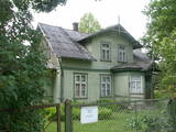 |
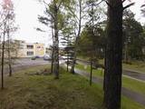
This is the one street in Ķemeri where the towns' wooden buildings have been preserved to the greatest degree. Turning onto Durbes Street from Karogu Street, you will find the Miervaldis Ķemers Museum, which is focused on the well known Latvian cultural activist, pastor and painter (1902-1980). The museum is at Durbes Street 21. |
|
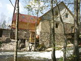 |
The Narūta River which flows out of Lake Ežezers is approximately 1 km long and ends at the small Obiteļi windmill lake. On the right bank of the river is a windmill that was built around 1900. Today the site has the Obiteļa leisure centre with a sauna and banquet facilities. |
|
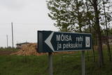 |
Neliela apdzīvota vieta nacionālā parka ziemeļrietumu daļā, kur kādreiz atradusies Rebases muiža. Mūsdienās no tās saglabājušās klēts atliekas, pie kurām apskatāms interesants vēstures liecinieks – sens akmens, ko izmantoja kulšanas procesā (Peksukivi). |
|
 |
Divas mazas apdzīvotas vietas nacionālā parka dienvidrietumu daļā. No kādreiz piecām Kolski ciema saimniecībām līdz mūsdienām ir saglabājusies tikai viena. Kolski iedzīvotājus līdzīgi kā citviet Baltijas valstīs pēc 2. pasaules kara deportēja uz Sibīriju. Kolski apkārtnē redzamie mājdzīvnieki „apsaimnieko” šejienes pļavas, neļaujot tām aizaugt ar mežu. Tādējādi tiek uzturēta apkaimes vēsturiskā ainava. 3 km dienvidrietumos meklējams Kobasāres ciems. Tā nosaukums (koopa no igauņu valodas nozīmē ala, saar – sala) atgādina par Ziemeļu kara notikumiem, kura laikā cilvēki slēpušies pašu raktās alās. Kobasārē un tam blakus esošajā Apjas (Apja) ciemā var izbaudīt patiesi 21. gadsimtam nepierastas lauku ainavas. |
|
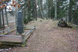 |
The Middle Ages and the beginning of the last century cemetery at the church of Mazirbe. It is surrounded by a moss-covered stone fence. There you can find a number of interesting sights-Werewolf's Tomb, Old Taizelis Tomb, Grand Pine, etc.. |
|
 |
Salos, Vaišnoriškė, Strazdai, Šuminai sind die bewohnten Dörfe im Augštaitija- Nationalpark, in denen historische Einzelgehöfte mit Holzgebäuden erhalten sind. |
|
 |
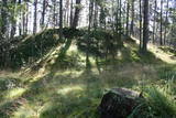
This is an ancient and important place for trade and craftsmanship on the left shore of the Rīga hydroelectric power plant reservoir. It rises some 15 m above the Daugava River. The Zemgale port that is described in historical documents is thought to have been located alongside the castle hill and at the mouth of the little Varžupīte stream. Antiquities that have been dug up here suggest that the castle hill and its adjoining ancient settlement were populated until the late 12th century, when the importance of Daugmale began to shrink because of rapidly growing Rīga. The foundations of the castle hill have been shored up. |
|
 |
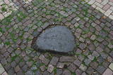
It lies between Pīlādžu street and the left bank of the river Siliņupe. In the 3rd to 2nd millenium B.C., there was a fishermen and hunters' settlement in the place of which there is installed an informational commemorational stone (Sculptor O.Skarainis). The settlement near the river Siliņupe is the oldest known human settlement in the area of the Ķemeri National Park. There are found many artifacts: pottery fragments and arrow tips, flint and amber pieces, etc..It is possible that the adjacent residential area has been the place of a cemetery. A small portion of the finds is displayed at the Lapmežciems Museum, the other ones are located in the National History Museum of Latvia. |
|
 |
The biography of Krišjānis Valdemārs tells us that during the summer of 1839, teachers and students from the Lubezere school spent a few days on the coastline in Roja, where Valdemārs would later help to build a maritime school. The area was breath-taking and unforgettable for the little boy. “The noble appearance of the sea grabbed the spirit of the young man so powerfully that during those three days, I thought about nothing other than the noble sea, with childish courage that allowed me to prepare a plan for a deeper port in the Roja River so that larger boats and small ships could enter it,” Valdemārs wrote. (Source: Roja TIC) |
|
 |
One of the most interesting objects in Bigauņciems, the road begins at the seashore, crosses the Vecslocene River (there is no bridge, but hikers and bikers can get across it), and then continues as a forest road to Lake Melnezers. |
|
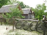 |
This is a very interesting monument to the history of fishing in the region. These areas had docks and areas where fishermen built huts to store their nets and other inventory. The areas also had a social role – men came together to discuss work that had to be done, while women and children wove nets. The huts at Bigauņciems were eventually washed into the sea, and the areas at Ragaciems have been partly destroyed. The ones at Lapmežciems are the ones which are best preserved. One of the net huts has been restored, but the others are in very poor condition, indeed. That may be why you should focus on these huts as you walk along the beach. Make sure that you take some pictures of this historic location. |
|
 |
Near the place where the Kilmiņupe River flows into the sea is the legendary Trommel castle hill, which was a Medieval fortification. It is some 100 m from the Kraujas homestead. An archaeological dig in 1977 found fragments of bricks and pot-bellied stoves, which suggests that the fortifications date back to the Middle Ages. The location also is linked to stories about a pirate, Trommel, who buried his loot here. The holes in the area have been left behind by treasure hunters. Trommel supposedly robbed ships in the Bay of Rīga from the shores of Kurzeme to Roņu Island. Many ships docked here in ancient times, waiting for better winds so that they could pass by Cape Kolka. The pirate made use of this fact, also pillaging property from sunken ships. It is said that Trommel lived in a stone castle. (Source: Roja TIC) |
|
 |
Auch Königstor (Kuningavärav) genannt. Im Barockstil gebaut ist ein Teil der früheren mittelalterlichen Stadtbefestigung. Der Beginn des alten Postweges. |
|
 |
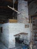
Vijciema čiekurkalte savu darbību uzsāka 1895. g. pēc plašiem apkārtnes meža ugunsgrēkiem. Šobrīd tā ir vecākā Latvijā un viena no vecākajām Eiropas čiekuru kaltēm. Pēc ceturtdaļgadsimta dīkstāves to atjaunoja 1992. g. Vienreizējais kultūrvēstures piemineklis ir saglabāts pilnīgā darba kārtībā. Ēkā atrodas 19. gs. beigās ražotā autentiskā iekārta un aprīkojums. Arī mūsdienās to izmanto čiekuru žāvēšanai. Ekskursijas laikā apmeklētāji var iepazīties pilnu čiekuru (g.k. – priedes) apstrādes ciklu. Ziemā, kad ir īstais čiekuru žāvēšanas laiks, te demonstrē kaltēšanas procesu. Vijciema čiekurkalte ir iekļauta Eiropas kultūras mantojuma objektu sarakstā. |
|
 |
In Metsanurme Village Centre you can see restored old threshing barn, limestone barn oven and few tools that were used ages ago. You could be also interested in seeing an outdoor exhibition which focuses on historical agricultural tools. All of this is made to look interesting to not only locals but also visitors. |
|
|
|
Die Straße führt durch die ehemaligen Fischerdörfer. Eine bessere Radfahr-Alternative auf der Strecke zwischen Häädemeeste und Ainaži. |
|
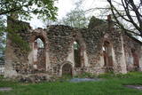 |
Lullemē atrodas blakus parka robežai, bet arī šo vietu ir vērts pieminēt kā vienu no apskates objektiem. Lullemē uzmanību piesaista viena otrai blakus stāvošās baznīcas. Mūsdienās redzamās 15. gs. celtās Sv. Marijas baznīcas drupas ir liecinieks 2. pasaules kara notikumiem, kad 1944. g. baznīcu sagrāva. Jaunā baznīca ir celta 1997. gadā. Ciema rietumdaļā uzstādīts piemineklis, kas veltīts brīvības cīņās (1919. – 1920.) kritušajiem. |
|
 |
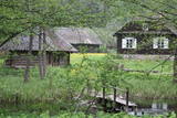
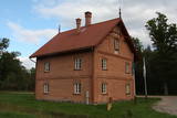
Approximately 200 metres to the North-East from the Liv People's Centre, along the Mazirbe-Košrags road, there is the Seppes homestead. The little log granary was built in the 1920s and 1930s by an Estonian fisherman and builder who arrived in Mazirbe from Saaremaa. He was called Jēkabs Jaga. On the other side of the road is the Kalši home, which was built in the early 20th century. It has been restored, but the bricks that were made in a local kiln were preserved for its walls. |
|
 |
The Strūves Park is toward the northwest of Jēkabpils, on the left bank of the Daugava, and opposite the Ādamsona (Krustpils) island. The park was established in the 19th century as a place where the city’s residents could relax and hold celebrations. It can be said with absolute certainty that this is a place of global importance, because the park contains a memorial stone to Professor Friedrich Georg Wilhelm Struwe (1793-1864) from the University of Tartu. He was an astronomer and geodesist. The stone is at a place where Struwe completed his land survey of the Vidzeme Province of the Russian Empire. The meridian location which Struwe identified (and other points related to those locations are found in many other European countries) is on the UNESCO list of world heritage. |
|
