
| No | Name | Description |
|---|---|---|
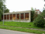 |
A straight street which runs through Ķemeri in the northwestern-southeastern direction. The street's name is a proof that it is the former historical boundary between the regions of Vidzeme and Kurzeme. Near the intersection of Robežu and Tukuma streets, you can notice the former pharmacy building-the memory of the former resort of the all-union significance. On the walls there has survived the pharmacy-related symbolism. |
|
 |
Salos, Vaišnoriškė, Strazdai, Šuminai sind die bewohnten Dörfe im Augštaitija- Nationalpark, in denen historische Einzelgehöfte mit Holzgebäuden erhalten sind. |
|
 |
The Cemetery of the Brethren. A wood
pathway leads from the RīgaVentspils highway
(A10) to a memorial rock dedicated to men who
fell during World War II.
|
|
 |
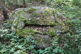
This is an ancient and important place for trade and craftsmanship on the left shore of the Rīga hydroelectric power plant reservoir. It rises some 15 m above the Daugava River. The Zemgale port that is described in historical documents is thought to have been located alongside the castle hill and at the mouth of the little Varžupīte stream. Antiquities that have been dug up here suggest that the castle hill and its adjoining ancient settlement were populated until the late 12th century, when the importance of Daugmale began to shrink because of rapidly growing Rīga. The foundations of the castle hill have been shored up. |
|
 |
Kolkja, Kasepää and Varnja are another example of one-street villages of Old Believers who fled to Estonia from Russia in the 17th and 18th centuries. |
|
 |
Near Mākoņkalns hill there is a trail that is mowed in the summer and leads to several historical rocks – Plakanais (Flat) rock, Āža muguras (Ram's Back) rock (on which you can clamber), and the Jaunstašuļi Velna pēdas (Devil's Footprint) rock, on the surface of which is a shape similar to a human footprint. There are signs along the side of the road leading to the trail. |
|
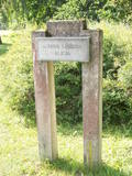 |
Marking of the Jānis Lībietis Alley in the
Ķemeri Park – Lībietis directed the institution
which managed the Ķemeri sulphurous springs
from 1928 until 1944, and the monument to
him is at the end of the Jānis Lībietis Pathway
|
|
|
|
The Smārde saloon has a very long history,
and food is served here. There is a car park, and
approx. 100 m to the East is a cemetery and
monument to commemorate soldiers who fell
during World War II.
|
|
 |
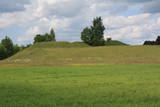
This partly forested hillock stands 40 metres above the surrounding area and offers impressive views. The fact that this was once a castle hill is attested by the presence of a moat and remnants of defensive fortifications. It is thought that Lettigalian tribes settled here in the 10th century AD. You can climb the hillock to take a look at the surrounding landscapes. |
|
 |
The cosy land road along the sea is 1 km long, and it offers a look at the wonderful aspects of the village. To the right are rocks from the sea, as well as miniature flower gardens on the seashore with tempting benches and overturned boats. On the side of the shore is the Kaltene library, which is more than 100 years ago. It was initially a summer home for Baron Nolken, and it was built in 1899. Later it was rebuilt several times and took on new roles. An elementary school was installed here in 1926, after which it became a club and then, in 1992, a primary school once again. The path runs along beautiful seashore homesteads, among which one can find the former homes of old fishermen and ship builders such as Burliņi. At one time, the Žulnieki portage at Smilgas was the site of the kiln of blacksmith Pēteris Valdemārs. He was the main blacksmith for ships between Kaltene and Upesgrīve. (Source: Roja TIC) |
|
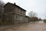 |
Taisnā Celtnieku iela ir bijušās Liepājas – Aizputes šaursliežu dzelzceļa (celta 1900. gadā, 49 km gara) līnijas „trase”, kuras malā (Celtnieku ielā 50) redzama bijusī dzelzceļa stacijas ēka. |
|
 |
Near the place where the Kilmiņupe River flows into the sea is the legendary Trommel castle hill, which was a Medieval fortification. It is some 100 m from the Kraujas homestead. An archaeological dig in 1977 found fragments of bricks and pot-bellied stoves, which suggests that the fortifications date back to the Middle Ages. The location also is linked to stories about a pirate, Trommel, who buried his loot here. The holes in the area have been left behind by treasure hunters. Trommel supposedly robbed ships in the Bay of Rīga from the shores of Kurzeme to Roņu Island. Many ships docked here in ancient times, waiting for better winds so that they could pass by Cape Kolka. The pirate made use of this fact, also pillaging property from sunken ships. It is said that Trommel lived in a stone castle. (Source: Roja TIC) |
|
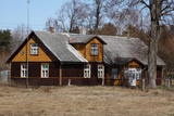 |
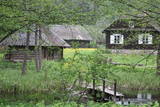
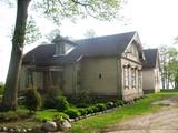
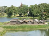
This set of buildings represents a homestead for a fisherman and a farmer. The house was built in 1926, and the ancillary buildings all date back to the first half of the 20th century. The homestead can be seen from the road. |
|
 |
This is one of comparatively few castle hills along the banks of the Daugava River that is not overgrown with trees and bushes, which means that it has a classical castle hill form that is part of the local landscape. The Dignāja castle hill was settled during several periods, particularly between the 5th and the 9th century AD, when it was an important centre. Archaeologists have found that Lettigalian tribes lived here. After the Holy Crusade invasion, the Livonian Order built a castle on the hill that has not survived. It is said that there was once an underground passageway under the hill. The hill itself offers a lovely view of the Daugava River valley. World War I trenches have been preserved the area. There was once a settlement at the foot of the hill. |
|
|
|
Die Straße führt durch die ehemaligen Fischerdörfer. Eine bessere Radfahr-Alternative auf der Strecke zwischen Häädemeeste und Ainaži. |
|
 |
Located on the left bank of the Venta River 100 m to the Northwest of the Liepāja (A9) highway bridge across the river. The antique castle hill was the site of a Livonian Order that existed from the 14th to the 18th century before being sacked during the Great Northern War. No part of the castle has survived. A stage was built on the castle hill in 1987, and it is a popular venue for various events. The hill is surrounded by a park with wooden chairs that were designed by the sculptor Ģirts Burvis in honour of the kings of Courland. There is a viewing platform, and there are legends about underground passages and a white lady who appears only once every 100 years. |
|
 |
The Lake Castle of Āraiši is of pan-European importance. It is a reconstructed Lettigalian lake castle from the 9th or 10th century, and it is the only place in the Baltic States at which visitors can learn about how people lived more than 1,000 years ago. The castle offers various thematic events. |
|
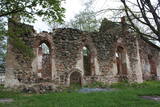 |
Lullemē atrodas blakus parka robežai, bet arī šo vietu ir vērts pieminēt kā vienu no apskates objektiem. Lullemē uzmanību piesaista viena otrai blakus stāvošās baznīcas. Mūsdienās redzamās 15. gs. celtās Sv. Marijas baznīcas drupas ir liecinieks 2. pasaules kara notikumiem, kad 1944. g. baznīcu sagrāva. Jaunā baznīca ir celta 1997. gadā. Ciema rietumdaļā uzstādīts piemineklis, kas veltīts brīvības cīņās (1919. – 1920.) kritušajiem. |
|
|
|
(V-1279) linked Kuldīga and Alsunga before a new road was built. The lovely gravel road weaves through forests and farmland. During appropriate weather, it can be used as an alternative road to learn about the landscapes of the Suiti region. You can also bike down the road. |
|
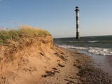 |
Harilaidas galā no jūras ūdens paceļas 26 m augstā Kīpsāres bāka – viena no neparastākajām Igaunijas bākām. Tā celta 1933. g., kad jūra no bākas atradās ~ 100 m attālumā. Krastu noskalošanas rezultātā tā tagad ir viļņu ieskauta. |
|
