
| No | Name | Description |
|---|---|---|
 |
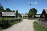
Cēsu centrālais laukums – Vienības laukums (20.gs.sākumā – Konventa laukums) – atgādina par Cēsu kauju notikumumiem, kuru nozīme un ikviena dalībnieka ieguldījums aprakstīti devīzē uz pieminekļa “No zobena saule lēca”. Cēsu kaujas 1019.gada jūnijā bija svarīgs Latvijas valstiskuma vēstures pagrieziena punkts, kad apvienotais latviešu un igauņu karaspēks sakāva vācu landesvēru, kas apdraudēja Baltijas valstu pastāvēšanu. Vienības laukums turpina būt par nozīmīgu notikumu liecinieku. 1989.gada 23.augustā daudzu cēsnieku ceļi veda uz Vienības laukumu, kuram cauri vijās Baltijas ceļš. |
|
 |
Ein zweistöckiges Holzhaus auf dem Uošvės-Hügel mit wunderschönem Blick aufs Haff. Hier hat drei Sommer der Träger des Nobelpreises, deutscher Schriftsteller Thomas Mann (1875 – 1955) verbracht. |
|
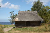 |
Altja village in Lahemaa National Park was first recorded in writing in 1465. It is a typical seaside village with houses along one street. Traditional farmsteads of Uustalu and Toomarahva from the late 19th C are open to visitors. Renovated fishnet sheds are located on Altja Cape. The village has a swing and a tavern (Altja Kõrts) providing national food |
|
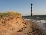 |
Harilaidas galā no jūras ūdens paceļas 26 m augstā Kīpsāres bāka – viena no neparastākajām Igaunijas bākām. Tā celta 1933. g., kad jūra no bākas atradās ~ 100 m attālumā. Krastu noskalošanas rezultātā tā tagad ir viļņu ieskauta. |
|
|
|
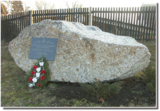
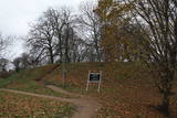
The Cemetery of the Brethren. A wood
pathway leads from the RīgaVentspils highway
(A10) to a memorial rock dedicated to men who
fell during World War II.
|
|
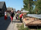 |
Kolkja, Kasepää and Varnja are another example of one-street villages of Old Believers who fled to Estonia from Russia in the 17th and 18th centuries. |
|
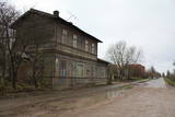 |
Taisnā Celtnieku iela ir bijušās Liepājas – Aizputes šaursliežu dzelzceļa (celta 1900. gadā, 49 km gara) līnijas „trase”, kuras malā (Celtnieku ielā 50) redzama bijusī dzelzceļa stacijas ēka. |
|
 |
The biography of Krišjānis Valdemārs tells us that during the summer of 1839, teachers and students from the Lubezere school spent a few days on the coastline in Roja, where Valdemārs would later help to build a maritime school. The area was breath-taking and unforgettable for the little boy. “The noble appearance of the sea grabbed the spirit of the young man so powerfully that during those three days, I thought about nothing other than the noble sea, with childish courage that allowed me to prepare a plan for a deeper port in the Roja River so that larger boats and small ships could enter it,” Valdemārs wrote. (Source: Roja TIC) |
|
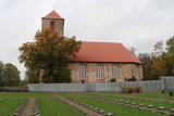 |
The graveyard that is alongside the Lestene Lutheran Church is the final resting place for more than 900 soldiers who fell during World War II, particularly during battles at the so-called Fortress of Kurzeme, as well as in Zemgale and Vidzeme. The sculptress Arta Dumpe designed the commemorative monument “Mother Motherland – Latvia.” The cemetery of the brethren is the second largest resting place for soldiers from World War II after the Cemetery of the Brethren in Rīga. The names of some 11,000 soldiers are engraved on the gravestones. |
|
 |
Located on the left bank of the Venta River 100 m to the Northwest of the Liepāja (A9) highway bridge across the river. The antique castle hill was the site of a Livonian Order that existed from the 14th to the 18th century before being sacked during the Great Northern War. No part of the castle has survived. A stage was built on the castle hill in 1987, and it is a popular venue for various events. The hill is surrounded by a park with wooden chairs that were designed by the sculptor Ģirts Burvis in honour of the kings of Courland. There is a viewing platform, and there are legends about underground passages and a white lady who appears only once every 100 years. |
|
 |
Musteikas pirmsākumi ir meklējami jau 18. gs. Līdz Musteikai no Marcinkones puses var nokļūt pa grantētu ceļu, kas ved gar bijušajiem kolhoza zivju dīķiem. Automašīnu var atstāt ciema sākumā un izstaigāt to ar kājām, izjūtot veco ēku smaržu un šarmu. Musteikā atrodas Dzūkijas biškopības vēsturei veltīts „dzīvs” muzejs, kur stropos dzīvo bites, bet tā saimnieks ir biškopis pēc aicinājuma un būtības. Ja palūgsiet, viņš demonstrēs – kā ar krama, metāla un posas piepes palīdzību senos laikos ieguva uguni. |
|
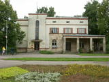 |
The building was erected during the first period of Latvian independence, and it maintained its functions for a long time. The building is located at Tukuma Street 30. Beginning in 1940, the post office had an automated telephone central. The Postal Service no longer uses it, and the building can only be viewed from the outside. |
|
 |
The memorial stone to Augusts Muižulis,a recipient of the Lāčplēsis Military Order, is placed in the Lapmežciems, at the edge of the road (P 128, Jūrmala-Talsi) at the marker for the 9th kilometre. A. Muižulis, (189 –1941) was a lieutenant colonel in the No. 4 Valmiera Infantry Brigade. The adjacent Tuteņi homestead is his native home. |
|
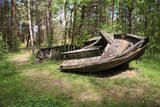 |
In the 1960s, the Soviet Union banned individual fishing in the sea, and the motor boats which had no other purpose were simply beached in the dunes. It is said that members of the Border Guard often set the boats on fire. Another story is that the Border Guard banned an ancient tradition of burning old boats on Summer solstice Eve. Along the road to the cemetery is the old net barn, which is a residential building today. |
|
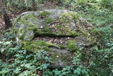 |
Near Mākoņkalns hill there is a trail that is mowed in the summer and leads to several historical rocks – Plakanais (Flat) rock, Āža muguras (Ram's Back) rock (on which you can clamber), and the Jaunstašuļi Velna pēdas (Devil's Footprint) rock, on the surface of which is a shape similar to a human footprint. There are signs along the side of the road leading to the trail. |
|
|
|
During the latter half of the 19th century, one of the largest ship building facilities was located here between the Dzeņi and Lielkalni homesteads. It was known as the Ķirbiži and then the Vitrupe shipyard, though nothing remains of it. 28 ships were built here between the 1860s and 1929. |
|
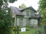 |
This is the one street in Ķemeri where the towns' wooden buildings have been preserved to the greatest degree. Turning onto Durbes Street from Karogu Street, you will find the Miervaldis Ķemers Museum, which is focused on the well known Latvian cultural activist, pastor and painter (1902-1980). The museum is at Durbes Street 21. |
|
 |
This was an island after the Rīga hydroelectric power plant created a reservoir, and before that it was a peninsula on the Left Bank of the Daugava. During World War I, there were massive battles between Latvian Riflemen and a much larger German army on Death Island. On December 25, 1916, the Germans used poisonous gas against the Latvian troops. In honour of this, the architect Eižens Laube designed a monument to fallen Latvian riflemen on the northern shore of Death Island. It was unveiled in 1924. Death Island can be reached by boat, and the trenches and graves there are of interest. There is a pier for boats on the north-western shore of the island, and nearby is a location for leisure. Some of the trenches and dugouts have recently been restored. The battles were described by Aleksandrs Grīns in his masterpiece, “Snowstorm of Souls.” |
|
 |
This ancient Courlandian castle hill has remnants of an ancient city. Historical sources indicate that in 1263, the Courlandians handed the castle over to the Livonian Order without a battle and that the castle was then burned down. The name of the place, Skābaržkalns, has to do with the name of the city, because hornbeam trees in the area were once known as grobi. |
|
 |
The Strūves Park is toward the northwest of Jēkabpils, on the left bank of the Daugava, and opposite the Ādamsona (Krustpils) island. The park was established in the 19th century as a place where the city’s residents could relax and hold celebrations. It can be said with absolute certainty that this is a place of global importance, because the park contains a memorial stone to Professor Friedrich Georg Wilhelm Struwe (1793-1864) from the University of Tartu. He was an astronomer and geodesist. The stone is at a place where Struwe completed his land survey of the Vidzeme Province of the Russian Empire. The meridian location which Struwe identified (and other points related to those locations are found in many other European countries) is on the UNESCO list of world heritage. |
|
