
| No | Name | Description |
|---|---|---|
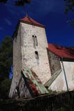 |
Iespaidīgais un monumentālais dievnams uzcelts 1816. gadā. No baznīcas nozīmīgākajām interjera detaļām ir saglabājušās ērģeles, altārglezna, lustra un kroņlukturis. Jāpiebilst, ka baznīca savā pastāvēšanas laikā nav pārtraukusi savu darbību. |
|
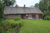 |
The distinguished Latvian author an painter Jānis Jaunsudrabiņš (1877-1962) spent six years of his childhood at Riekstiņi in Nereta. He was born into a servant family and moved to Riekstiņi together with his mother after his father passed away. The household inspired him for his "White Book." In honour of Jaunsudrabiņš, a museum was opened at Riekstiņi in 1967, and it is in an authentic Selonian farm with its spirit and aromas. You can tour the residential building and the homestead's granary and wheelhouse, also houshold building from 1820. The apple orchard has trees that are 100 years old and older. Nearby is the Ķišķi cemetery (on the side of the Vecumnieki-Ilūkste road), where members of the Jaunsudrabiņš family were interred and Jānis Jaunsudrabiņš was reburied in 1997. The Nereta Administrative District still has many single family farms and place names which Jaunsudrabiņš mentioned in his books. |
|
 |
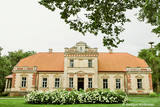
Puša Manor - Chapel was built in the end of the 18th century; it is located
in the Pušas Manor park that was built in the middle of the 19th
century. Both are permanent local architectural monuments.
|
|
 |
The Jakiškiu Estate was first mentioned in documents in the late 16th century. The estate had elements of Classicism in terms of its architecture. Among the buildings, the only ones that have survived are the mansion, an ice cellar and a steam-driven windmill. The estate has not been restored, so it is still authentic. Its artistic soul is preserved by various objects that remain from the time when people lived at the estate and from the Soviet era. Alongside the estate are a few fragments of a park, which covers approximately 2 ha. There is an ancient alley of linden trees that are on both sides of the entrance road, as well as several other valuable types of trees and a small pond. |
|
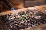 |
Apmeklētājiem tiek piedāvāta ekskursija ar stāstiem par Limbažiem, kas kādā veidā saistīti ar sudrabu. Ekskursijas laikā iespējams apskatīt paraugdemonstrējumus lodēšanā. Sadarbībā ar juvelieriem, darbnīcā būs iespējas apgūt prasmes darbam ar misiņu un sudrabu, tiks piedāvātas arī meistarklases. Pēc iepriekšējas pieteikšanās grupām būs pieejamas arī O.Auzera lekcijas par sudraba ietekmi uz veselību. Ekspozīcija atvērta apmeklētājiem no trešdienas līdz svētdienai no pl.10:00-17:00, citā laikā grupām- pēc iepriekšēja pieteikuma. Ieejas maksa: |
|


