
| No | Name | Description |
|---|---|---|
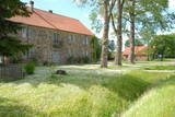 |
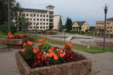
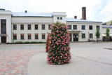
On the way to Turaida you must definitely stop at Gutmana cave. It is the widest (12 m) high (10 m) and in terms of volume - one of the biggest Latvian caves (cave like niche), which is also an important cultural and historical site, place rich with stories (most popular of Turaida Rose), surrounded by ancient walls and ceiling inscriptions (oldest from the end of 17th century). A spring originates from the cave; it is believed that it has healing properties. Turaida Museum reserve with Batlic scale outstanding monuments whose history stretches over 1000 years in the distant past is located at the point where the right mainland of Gauja valley is split by deep ravines of several small streams. Their exploration can be started with Turaida manor (first mentioned in 16th century), which is an outstanding example of Vidzeme manors. 21 buildings, built between the 18th century until the beginning 20th century are preserved until now. Visitors can see the manor stables, coach house, sauna, forge, fish cellar, barn, foreman house, the old residential buildings of landlord, and residential building of manor servants, oust house, etc. While walking in Turaida direction, we will reach the grave of Turaida Rose, which relates with the legend of Turaida Maija, who sacrificed her life for love. Near the grave grows a great linden tree (poor condition), wich is believed to be planted on the grave of Maija. Turaida Lutheran Church that lies further is the third church in a row and one of the oldest (1750) Latvian wooden churches – single volume wood log building with a baroque tower. Here you can see the altar and pulpit (Middle of the 18th century), altarpiece "Golgotha" (end of the 17th century – beginning of the 18th century) and historical exposition. Tautasdziesmu (folksongs) Park stretches at the Dainu Hill, the development of which started in 1985, noting the 150th anniversary of father of Latvian folk songs – Krisjanis Barons. More than 26 stone sculptures created by the sculptor I. Ranka are exhibited here. This is also a place of annual folklore events. Before the construction of Turaida stone castle (started in 1214), wooden Liv castle stood here. Turaida castle belonged to the Bishop. It existed for a long time - until to the 1776 when it was burned down. In 1953 an extensive restoration works was started here; upper storey of main tower, barn building (exposition on Sigulda district), semi-circular tower and castle complex in the southern enclosure was restored. Now the museum exhibition is established at the castle premises, which tells about the historical events in the surroundings. |
|
 |
Plavinas and Stukmani region was inhabited already in the third century. During the Polish-Swedish War (1600-1629) at estuary of Aivekste in the Daugava River the Swedish war camp was formed, from which are preserved fortifications - bastions. They are one of the most impressive military formations of this kind in Latvia. Plavinas as a larger populated area started to develop in the nineties of the 19th century and in the beginning of 20th century after the construction of railway. Today Plavinas are more commonly known with dolomite production sites and spring flood area. |
|
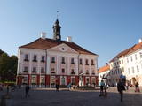 |
Formed on the left side of river Emajõgi, in the valley of Doma Hill. The centre of The Old Town of Tartu is Town Hall Square with Town Hall and the fountain "The Kiss of the Students" (symbol of the city). |
|
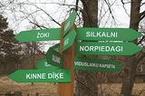 |
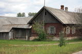
is seen as the newest village along the Livonian coastline. It was established during the 17th century. Košrags had 78 residents in 1826. The first reading school for Livonian children in the Dundaga seashore villages was opened at the Žoki homestead in 1832. One of the teachers was Nika Polmanis, who was the first Livonian to have completed a professional education. He also translated the Gospel of Matthew into the Eastern Livonian dialect. Košrags had a windmill, water mill and boat building facility. During the spring, job seekers from Saaremaa stopped here. A port was installed in 1932, and a breakwater to collect sea fertiliser followed in 1938. During the 1930s, Košrags was regularly visited by Finnish and Estonian linguists to study the folklore of the Livonians. The Norpiedagi homestead was built by Livonian activist Didriķis Volganskis (1884-1968). His son, Livonian cultural worker and pastor (in Finland) Edgars Vālgamā (Volganskis, 1912-2003) was born there. He translated the Andrejs Pumpurs epic "Lāčplēsis" into Finnish. Košrags today is a cultural monument of national importance. |
|
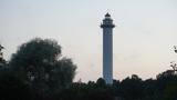 |
(formerly Pize and Pizā in Livonian). The current name of the village comes from a lighthouse (Mihailovskii majak) that was built during the age of the Russian Empire and named for the nephew of Tsar Alexander II. The lighthouse that is there now is the third one to be built on the site. It was built in 1957 and is the highest lighthouse in Latvia (57 m, can only be viewed from the outside). The Lutheran church in Mikeļtornis was built in 1893, and nearby is the Pize Saloon (1857), which is terrible condition. The saloon has a typical design from the 19th century and is the only venue of its type on the Livonian coastline. The first Livonian cultural activist, Jānis Princis (1796-1868), was born in Miķeļtornis, and he and son Jānis translated the Gospel of Matthew into the Western Livonian language. The two of them also wrote a collection of poetry, "Holy Songs and Prayers for Sailors." The only poetry book in Latvia prior to that was published by Blind Indriķis. A student of Vilhelms Purvītis, Livonian painter Andrejs Šulcs (1910-2006), was born at the Olmaņi homestead in Miķeļtornis. A monument to Livonian poets was installed at the local cemetery in 1978 and was the first monument dedicated to Livonians. There are plans to open an environmental object by artist Ģirts Burvis, "Century of Sailing Ships", in 2019. |
|
 |
Apdzīvota vieta ~ 1 km dienvidos no Daugavpils – Krāslavas (A 6) ceļa, kas pazīstama ar savu neparasto nosaukumu. Interesanti, ka vietvārds saistīts arī ar iedzīvotāju uzvārdiem, ko var redzēt tāda paša nosaukuma kapos. Ciema apkaimē pazīstams ir Lielo Muļķu svētavots, kuru gan nezinātājam ir grūti atrast, tādēļ ieteicams izmantot vietējā gida pakalpojumus, apvienojot šīs vietas izziņu ar biškopības saimniecības „Cīruļi” apskati. |
|
 |
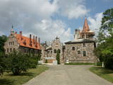
The town's name in historical sources was first mentioned in 1224. In 1340 Archbishop of Riga built a stone castle at the Latgalian hill fort (now - the Lutheran Church). In 1802 (owned until 1920) Vecgulbene estate was bought by Baron G. Wolf. Manors in the surroundings of Gulbene and Vecgulbene castle substantially suffered during the Revolution in 1905 and in the further historical events. Today, there is a substantial change in the landscape, especially in the area of White Castle, where a large-scale restoration works occurred in recent years. Either way, - Gulbene is the place worth visit to get new impressions and knowledge. |
|
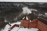 |
Construction of the Sigulda castle was begun by the Order of Brethren of Swords in 1207, but in 1236 it was rebuilt for the needs of the Livonian Order. The building suffered much damage during wars in the latter half of the 16th century and the early part of the 17th century. It was burned down during the Great Northern War and was not restored. Visible today is the south-western wing of the castle’s convent building and the main gate tower, behind which is the internal forecastle with an open-air stage that offers an impressive view of the ancient Gauja River valley. The new Sigulda castle was built between 1878 and 1881, and it was owned by Count Kropotkin. From 1923 until 1940, the castle housed a centre for writers, and during the Soviet Union it was a hospital for cardiology patients. Since 2003, the Sigulda Administrative District Council has been located here. The buildings that have been preserved include a wooden home (mid-19th century), where the Kropotkin family used to live, a granary (late 18th or early 19th century), the home of the gardener (19th century) and a brick wall (19th century). If we go to the north-eastern direction, we will find the Vējupīte valley less than two kilometres away. It includes the shallow (3.6 m) but high (6.1 m) Pēteris cave and the deep Pūču valley with the little Kraukļupīte River. At the place where the two valleys come together we find the Satezele castle hill (its flat surface is 90 x 75 m), where, in the early 13th century, the oak castle of the ruler of Livonian lands, Dabrelis, was once found. Nearby is the Kraukļu valley, with 11 m sandstone walls and a cave that is 5.2 m deep. Nearby is the Paradise (Painter) hill, which offers a lovely landscape that has been painted and photographed since ancient times. There is a Ferris wheel in the western part of Sigulda that is open during the summer, as well as an aerial tram that is the only transport vehicle of its type in the Baltic States and was installed in 1969. The cable that carries the tram is 1,060 metres long and links the shores of the ancient Gauja River valley between Sigulda and Krimulda. The cable is approximately 40 metres above the Gauja. The south-western part of Sigulda features the mighty Beite cliff which is split by a deep stream valley. To the west of the cliff is the Emperor’s View viewing area that is 67 m above the Gauja and offers a good view of Krimulda and the Turaida Castle. A viewing area was established here in 1862, when Tsar Alexander II of Russia visited Sigulda. The wooden Emperor’s chair is to the east of the viewing area. The Turaida Museum Reserve is in the place where the shore is split by deep valleys carved out by streams. It features several outstanding monuments that are as much as 1,000 years old. Of note are the Turaida Estate (21 buildings), the grave of the Rose of Turaida, the Turaida Lutheran Church (1750), which is one of the oldest wooden churches in Latvia) and the Turaida Castle. Folksong hill, which is nearby, is used for various thematic events. |
|
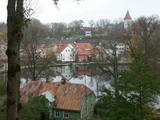 |
The historical centre of Talsi, which is known as the town of nine hillocks. The historical construction around Baznīckalns hill, Lake Talsi and Lake Vilkmuiža mostly dates back to the 19th century. Lielā Street is particularly beautiful with its low-rise buildings (two or three floors and ridged roofs). There are beautiful views from the area around Lake Talsi and Ķēniņkalns hill. |
|
|
|
One of the oldest towns in Latvia, about which data can be found already beginning from 1378. As a populated area it formed at the banks of the Tebra River (the side of Riga-Prussia road), where once the fortified wooden castle Beida of the Cours Land Bandava was located. In the medieval times Aizpute was the centre of Kurzeme bishopric. After joining Kurzeme to Russia in 1795, Jews settled for living in Aizpute. Today travellers in Aizpute are most attracted by the ancient city environment that is still alive here, as well as by the historical centre of the city and the castle ruins. |
|
 |
Madonas centrālais laukums, kas vēl 20. gs. sākumā bija tirgus laukums. Pēc apjomīgās restaurācijas tas ir kļuvis par ievērības cienīgu pilsētvides objektu. Laukuma ziemeļu pusē atrodas pilsētas un novada pašvaldība un Madonas novada TIC. |
|
|
|
This village is at the place where the Irbe (Dižirve, Īra) River flows into the sea, and it is on both shores of the river (sea side and land side). The name of Irbe was recorded for the first time in a 1310 border agreement between the bishop of Kurzeme and the Rīga Dome Capitol. The name of Lielirbe (Irvemūnde) was recorded for the first time in a document from an arbitration court in 1387. At the end of the 19th century, the small port at Lielirbe was an active centre for the sale and transport of timber materials. In the late 19th and early 20th centuries, the largest number of sailing ships among villages on the western shore of Kurzeme was built there. In 1939, the village had some 300 residents, more than 70 houses and a Baptist church which is now at the Ventspils Open Air Museum. A narrow-gauge railroad passed through the village, which had a post and telegraph office, two grocery stores, an elementary school, a choir and a brass band. Lielirbe was one of the largest villages to disappear after World War II. Cultural historian Valda Marija Šuvcāne (1923-2007) was born in Lielirbe, and her daughter, Baiba Šuvcāne, is continuing her mother's work by writing important papers about life along the Livonian coastline. By 2019, a bridge is to be reinstalled across the Irbe River. |
|
|
|
Smarde is an ancient place, mentioned in the 13th century documents. Today it is a small village with railway station and shops. Northeast of Smārde - former peat extraction places are located in Smārde marsh. During World War I the front line was near Smārde, the vicinity of which is witnessed by the memorial sites. |
|
|
|
Entstanden als eine 6 km entfernte Arbeiterstadt des schon geschlossenen Ignalina-Atomkraftwerks. In der Stadtbebauung dominieren die für die Sowjetzeit typischen architektonischen Formen und Monumentalbauten. |
|
 |
Arī 18. novembra laukums. Tas sācis veidoties 18. gadsimtā kā tirgus laukums. Tā dominantes bija 1752. g. celtais rātsnams (nav saglabājies) un aptieka, kas šajā ēkā darbojas no 1810. g. līdz pat mūsdienām. 2010. gadā laukumā izveidota strūklaka, kam ir pilsētas ģerboņa forma. |
|
 |
Cesvaine was first mentioned in written sources in 1209. For each traveller in Latvia, the town is associated with the family of Baron Woolf, who bought the Cesvaine estate in 1815. Cesvaine experienced the economic boom after establishment of Plavinas Gulbene railway. Town suffered significantly during the World War II. At the end of 2002, the Cesvaine Castle was struck by the tragedy - a fire, which damaged most of the castle. Cesvaine Castle is "recovering" by means of large public, state and local government support and still keeps the status as a significant tourism attraction in a scale of Vidzeme and Latvia. |
|
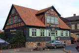 |
From the historical and architectural perspective, this is an interesting monument to urban construction between the 17th and 19th centuries. Old Liepāja is in the area of the old market and Kuršu Square, where merchants sold their wares beginning in the 1560s. Until 1792, Kuršu Square was also where punishments were implemented. The current Pētertirgus pavilion was installed alongside the square in 1910. A map shows that the network of streets has partly preserved the chaos of street planning that was typical in Medieval towns. |
|
 |
Old Town Square is the city’s historic centre. It was here, on February 12, 1670, that Duke Jacob of the Duchy of Courland proclaimed the establishment of a town. During the early 20th century, the square was covered in paving stones, and the city market was held there. On the sites of the square are the People’s Centre, the Unitarian Church and a tourism information centre. In the square are a water pump, an enormous scale, and a sculpture of a cougar, which is the symbol of Jēkabpils. From here you can tour the historical centre of Jēkabpils with its narrow streets and low-story buildings. |
|
|
|
Neliela apdzīvota vieta, kuras apkārtnē jau izsenis iegūta kūdra un ārstniecības dūņas, kas izmantotas Ķemeru kūrortā. Kūdrā atrodas padomju laikā celtā dzelzsbetona rūpnīca, kura nodrošināja ar būvniecības materiāliem tagadējo Kauguru mikrorajonu.
|
|
 |
Tāpat kā Ventspils Rātslaukums, arī Tirgus laukums ir uzskatāms par pilsētas vēsturiskā centra nozīmīgu daļu, kura apkaimē ir saglabājies senais ielu plānojums. Kādreizējā Rātsnama vietā tagad slejas kariljonu zvana pulksteņu tornis. Tas zvana katru stundu, bet 12:33:44 un 00:33:44 ar īpašu melodiju ieskandina astronomisko Ventspils laiku. Tirgus laukumā ir aka, kas saulainā laikā darbojas arī kā Saules pulkstenis. Monētu automātā var izkalt īpašu piemiņas monētu. |
|
