
| No | Name | Description |
|---|---|---|
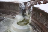 |
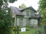
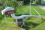
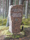
Built in the turn of the19th to 20th century. Next to it-on the right bank of the river Vēršupīte, there is located one of the most popular Latvian sulphur water springs, called "Small lizard". The spring runs out from a stone-designed lizard sculptured in 1949 (Sculptor J. Bajārs). Its water is healthy for using both internally and externally. Not far from the pavilion there can be found Jānis Lībietis alley sign. J. Lībietis worked in the position of a director for the sulphur water spring authority of Kemeri from 1928 to 1944. |
|
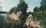 |
The castle hill is an island in the reservoir of the Pļaviņas hydroelectric power plant, and it can be accessed by boat. The ancient Selonian castle hill was settled several times between the 6th and the 12th century. This was the political and military centre of the Selonian region. In 1373, the Livonian Order built a stone castle on the hill, as it did on many other ancient hillocks. The castle was sacked in 1704 during the Great Northern War. Remnants of a square tower, a guard room and the 12 m embankment that once protected the castle are all that survive. Approximately 300 m to the North of the Sēlpils castle hill is Oliņkalns hill, which is underwater. |
|
 |
The historic stone, on which there is carved over 200 years old boundary-mark, sets the border between the Duchy of Courland and the Russian province. Nowadays, it sets the Babīte and Jelgava district boundary. The stone lies to the East of Kalnciems–Peat road (the south of the swamp Labais purvs) at the edge of a forest firebreak and it can be hard to find. To this end, the description of the road map may help: around 400 m south of the car parking lot at Lily Lake from Kalnciems-Peat road to the right (in the east) turns a forest road which leads down from hills Krāču kalni. It should be around 170 m to go until it abruptly turns to the right (to the southeast). Then you must go in this direction until after ~ 0.5 km to turn to the northeast where after further ~ 0.4 km of the current forest road intersection turn to the north. After ~ 0.4 km turn right (to the east) on a big firebreak, on the left (the north) side of which behind the drainage ditch during the non-leaf period there can be seen a rounded stone. Due to the poor condition of roads, the stone can be reached only on foot. |
|
 |
Ein zweistöckiges Holzhaus auf dem Uošvės-Hügel mit wunderschönem Blick aufs Haff. Hier hat drei Sommer der Träger des Nobelpreises, deutscher Schriftsteller Thomas Mann (1875 – 1955) verbracht. |
|
 |
Beliebte und eine der ältesten Straßen in Jurmala zwischen Dzintari und Majori. Die 1,1 km lange Straße mit Wirtshäusern, Sommercafés und Souvenirladen. |
|
 |
This is the one street in Ķemeri where the towns' wooden buildings have been preserved to the greatest degree. Turning onto Durbes Street from Karogu Street, you will find the Miervaldis Ķemers Museum, which is focused on the well known Latvian cultural activist, pastor and painter (1902-1980). The museum is at Durbes Street 21. |
|
 |
A straight street which runs through Ķemeri in the northwestern-southeastern direction. The street's name is a proof that it is the former historical boundary between the regions of Vidzeme and Kurzeme. Near the intersection of Robežu and Tukuma streets, you can notice the former pharmacy building-the memory of the former resort of the all-union significance. On the walls there has survived the pharmacy-related symbolism. |
|
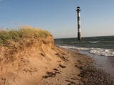 |
Harilaidas galā no jūras ūdens paceļas 26 m augstā Kīpsāres bāka – viena no neparastākajām Igaunijas bākām. Tā celta 1933. g., kad jūra no bākas atradās ~ 100 m attālumā. Krastu noskalošanas rezultātā tā tagad ir viļņu ieskauta. |
|
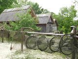 |
This is a very interesting monument to the history of fishing in the region. These areas had docks and areas where fishermen built huts to store their nets and other inventory. The areas also had a social role – men came together to discuss work that had to be done, while women and children wove nets. The huts at Bigauņciems were eventually washed into the sea, and the areas at Ragaciems have been partly destroyed. The ones at Lapmežciems are the ones which are best preserved. One of the net huts has been restored, but the others are in very poor condition, indeed. That may be why you should focus on these huts as you walk along the beach. Make sure that you take some pictures of this historic location. |
|
|
|
The Apakšceļs road – a lonely, forested and ancient road between
Košrags and Dūmele, with lots of interesting stories about the old Pitragupe
windmill, which never did grind any grain (the foundations are still there), and
about the boiler of a wrecked ship which a local baron used to produce tar.
This used to be a horse path which crossed the Bažas swamp. The great rock
of Dūmele is impressive, indeed.
|
|
|
|
Cēsu centrālais laukums – Vienības laukums (20.gs.sākumā – Konventa laukums) – atgādina par Cēsu kauju notikumumiem, kuru nozīme un ikviena dalībnieka ieguldījums aprakstīti devīzē uz pieminekļa “No zobena saule lēca”. Cēsu kaujas 1019.gada jūnijā bija svarīgs Latvijas valstiskuma vēstures pagrieziena punkts, kad apvienotais latviešu un igauņu karaspēks sakāva vācu landesvēru, kas apdraudēja Baltijas valstu pastāvēšanu. Vienības laukums turpina būt par nozīmīgu notikumu liecinieku. 1989.gada 23.augustā daudzu cēsnieku ceļi veda uz Vienības laukumu, kuram cauri vijās Baltijas ceļš. |
|
 |
To the East of the Ezermuiža-Dūmele road you will find the bed of the ancient Lake Dieviņezers. It was one of the largest lakes in Kurzeme in the past, being 7.5 km long and 1.6 km wide. A canal was dug in 1838 (Melnsilupe River today), and the water from the lake was siphoned to the sea so as to create fertile farmland. Residents of Ezermuiža have been involved in forestry work since the age when barons ruled the land. Dūmele is connected to Košrags by a lonely forest road that is known as the Bottom Road. A bike route runs down it. The Ziedkalni weekend house is in Dūmele. The "Ziedkalni" homestead in Dūmele offers spa services, cod fishing and accommodations. |
|
 |
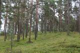
Kassinurme hills were formed during the last Ice Age, and an ancient stronghold and a sacred grove can be found in the hills. At the foot of the stronghold a stage has been built; a swing, tepees, a campfire place and a model of the stronghold are located in the forecourt. Nature, health and antiquities trails are located nearby. |
|
 |
This may be an ancient cult object, and today it is a little hill in the dunes that is a bit larger than other local hills. It is said that a church once sank into the dune. This tale suggests that there was a Christian or pagan prayer place here at one time. (Source: Roja TIC) |
|
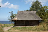 |
Altja village in Lahemaa National Park was first recorded in writing in 1465. It is a typical seaside village with houses along one street. Traditional farmsteads of Uustalu and Toomarahva from the late 19th C are open to visitors. Renovated fishnet sheds are located on Altja Cape. The village has a swing and a tavern (Altja Kõrts) providing national food |
|
 |
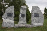
Around 6 km in length and an isolated route stretching between Ragaciems and Klapkalnciems where, as stories about olden days tell, robbers used to attack travelers. Around 1.5 km before Klapkalnciems (going from the side of Ragaciems), in the dune by the sea there is installed a commemorational stone dedicated to the Finnish jaeger battles. It was installed on December 09, 1997. The stone has "travelled" from the south-eastern part of Finland where in 1940 it served as an anti-tank defense. In the monument, there are engraved the words, "Here during World War I, from August 1916 to December fought the Finnish yeagers". In turn, in Klapkalnciems there is installed a commemorational stone in the place where there are buried five Finnish soldiers. |
|
 |
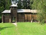
Eine der größten befestigten Siedlungen im Bezirk Harju, befindert sich auf einer Erhebung des natürlichen Kliffs Nordestlands. |
|
|
|
(V-1279) linked Kuldīga and Alsunga before a new road was built. The lovely gravel road weaves through forests and farmland. During appropriate weather, it can be used as an alternative road to learn about the landscapes of the Suiti region. You can also bike down the road. |
|
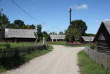 |
Musteikas pirmsākumi ir meklējami jau 18. gs. Līdz Musteikai no Marcinkones puses var nokļūt pa grantētu ceļu, kas ved gar bijušajiem kolhoza zivju dīķiem. Automašīnu var atstāt ciema sākumā un izstaigāt to ar kājām, izjūtot veco ēku smaržu un šarmu. Musteikā atrodas Dzūkijas biškopības vēsturei veltīts „dzīvs” muzejs, kur stropos dzīvo bites, bet tā saimnieks ir biškopis pēc aicinājuma un būtības. Ja palūgsiet, viņš demonstrēs – kā ar krama, metāla un posas piepes palīdzību senos laikos ieguva uguni. |
|
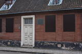 |
Находится на ул. Кунгу, д. 24.Одно из старейших зданий города - деревянный сруб с черепичной крышей, построенный во второй половине XVII века и прозванный в народе гостиницей мадам Хойер. Здесь в 1697 году во время путешествия «Великого посольства» в западную Европу останавливался (инкогнито) русский царь Петр I. Находящееся по соседству здание на ул. Кунгу, д. 26, является вторым старейшим жилым зданием Лиепаи (1699 г.) – жилой дом бургомистра города. Во время Северной войны здесь останавливался король Швеции Карл XII. Оба здания подлежат осмотру только снаружи. |
|
