
| No | Name | Description |
|---|---|---|
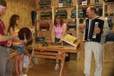 |
Here you will find a vast collection of antique instruments. You’ll learn about their history and about how they were manufactured. You can play music or commission or purchase homemade instruments. If you contact the venue in advance, the Igaunis family will organise a concert performance for you. |
|
 |
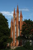
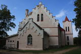
Atrodas Tirgoņu un Zāļu ielas krustojumā (Zāļu ielā 12). Interesanta ar faktu, ka šī ir vienīgā padomju laikā uzbūvētā (1948. g., pēc citiem avotiem – šajā gadā atjaunota) Latvijas baznīca. |
|
 |
For the first time, Balvi as populated area was mentioned in 1224. In the turn of 19th and 20th century, Balvi as manor and the parish centre formed as a larger settlement. During the Latvian freedom fights in 1919 Balvi was a place of establishment of Latgale guerrilla regiment. In 1926 Balvi obtained village rights, but by the 1928 became a town. During the World War II, while retreating, the German burnt down Balvi almost completely. People of Balvi are proud that the sun rises here about three minutes earlier than in the capital. Also the centre of the town has changed over the recent years. |
|
 |
Zemnieku saimniecība "Mežnoras" Raunā izveidota 1993.gadā. Saimnieki Aivars, Ārija un Līga Urbasti šobrīd audzē 1,6 ha vasaras un rudens avenes, arī nelielās platībās zemenes uz lauka un segtās platībās, siltumnīcā. Zemenes no "Mežnorām" parasti pieejamas laikā no maija vidus līdz oktobra vidum. "Mežnorās " audzē vasaras avenes "Norna", rudens avenes "Babje ļeto", “Polana”, populāro zemeņu šķirni “Polka”. No savā dārzā audzētajām ogām (upenes, jāņogas, ķirši, zemenes u.c.) Aivars gatavo mājas vīnu: "Mežnoru vīns pilnībā sākās Mežnorās. Tas piedzimst nevis mucās, bet sākas mūsu zemeņu vai aveņu laukā, un tās ir daudz dziļākas saknes, kas atstāj pēdas arī garšā”. Saimniecībā audzētais pieejams uz vietas Raunā, gan arī Straupes Lauku labumu tirdziņā, Straupes Hanzas tirgū, arī sezonā - Cēsu tirgū. |
|
 1 day
|
Dodieties ekskursijā, lai gūtu ieskatu lauku profesijā un dzīvesveidā, kā arī iegūtu jaunus iespaidus un labu atpūtu visai klasei. Ekskursijas sākumā apmeklējiet savvaļas dzīvnieku parku, kura voljēros dzīvo ~ 200 dambriežu. Tālāk dodieties uz saimniecību, kur aug vairāk nekā 100 augu sugu un šķirņu - ekskursija pa saimniecību, augu stādu iegāde, tēju, augļu un ogu degustācijas. Pēc tam apmeklējiet Skrīveru pārtikas kombinātu, kurā iespējams iegādāties gardās Gotiņkonfektes un doties ekskursijā. Brauciena noslēgumā - Skrīveru mājas saldējums ar stāstījumu par saldējuma gatavošanu un degustāciju. |
|
 |
The Cider House is located in the very centre of Sabile, right next to the historic Sabile Wine Hill. At the Cider House you will be able to taste a glass of cold Sabile cider and to taste and purchase wines made by various Latvian winemakers. |
|
 6 days
|
For the introduction into the Latvian craftsmanship make a visit to the Open-Air Ethnographic Museum in Riga where skillful masters will show you traditional skills. Out of Riga visit birch juice and wine maker which tells and shows how the birch juice is extracted and how preserved. You could taste it as well. Then go the area connected with ancient historic legends. Visit the museum of famous Latvian hero Lacplesis to see there Lielvarde Belt where the story is written using ancient secret symbols. At Koknese have a Viking boat trip around the picturesque Koknese castle ruins. Then visit farm which grows hemp and makes traditional hemp butter, goats farm and home-made traditional beer producer. Latgale region is famous for its pottery schools and "black" ceramics. You visit few workshops on the way as well as Ludzas Crafts Centre which provides great insight into local traditions. At the typical Latgalian farm try traditional sauna ritual and have proper regional meal. Further on stop at the Aglona Basilica which is a pilgrimage place. But for stomach pleasures visit Bread Museum, farm which produces tasty cheeses and other healthy diary products as well as visit herbal tea maker and learn there few health tips. Sightseeing of Daugavpils historic centre, impressive 19th century' s fortress are followed by visit to Lead Shot Factory where is a biggest shot towers in Europe which still works. On the way to Riga visit impressive Baltic pearl - Rundale Palace. |
|
 |
The saloon is in the most popular pedestrian thoroughfare in Jūrmala. The wooden building is typical of the town, has a nice interior and offers Latvian cuisine. The saloon offers the largest selection of Latvian draft beers. Latvian cuisine: Lamprey chops, pike haché, potted lamb a la Courland, sautéed pork ribs, fried Baltic plaice, bread soup. |
|
 |
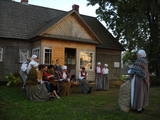
The owners have restored a fourth-generation bread oven to continue the tradition of baking bread. The family bakes bread in the autumn and winter months, from September to April. In the events organised by the Ventspils Seaside Museum they offer to taste traditional Latvian dishes that are in line with the rhythm of the seasons. |
|
 |
Traķu pirmsākumi ir meklējami Senajos Traķos, kas atrodas 4 km dienvidaustrumos no Traķu centra. Uzskata, ka Senos Traķus ir dibinājis Lietuvas dižkunigaitis Ģedimins (~ 1275. – 1341.) 14. gs. pirmajā pusē. 14. gs. otrajā pusē šeit uzcēla mūra pili, no kuras līdz mūsdienām ir saglabājušies tikai nostāvināti zemes vaļņi. Laikā no 1345. – 1382. g. tajā valdīja Ģedimina dēls – Ķēstutis (1297. – 1382.). Senajos Traķos dzimis arī viens no izcilākajiem viduslaiku Lietuvas valdniekiem – Ķēstuta dēls - Vītauts Dižais. Kā pilij, tā arī tās valdniekiem bija nozīmīga loma sekojošajos krusta karos un cīņās. 1391. g. pils tika sagrauta cīņas laikā ar Vācu ordeni, kādēļ arī zaudēja savu stratēģisko nozīmi. 1405. g. benediktīniešu mūki šajā vietā uzcēla baznīcu, bet 18. gs. beigās - jaunu un lielāka apjoma klosteri, kura vienu no korpusiem 1889. g. pārbūvēja par baznīcu. |
|
 3 days
|
Маршрут ведет по южной части исторического края Курземе и включает самые интересные туристические объекты, различные прибрежные пейзажи, и через Земгале возвращается в Ригу. На участке от Юркалне до Лиепаи маршрут идет вдоль побережья Балтийского моря, которое еще двадцать лет назад было закрытой режимной приграничной зоной, в которую попасть можно было только с наличием специального разрешения. В маршрут входят охраняемые природные территории, открытые для посетителей сельские хозяйства, в которых можно как попробовать, так и приобрести качественную продукцию, выдающиеся памятники культуры, Лиепая с выдающимся спектром военного наследия в Военном порте (Каросте) и оживленная Елгава, где обязательно надо подняться на башню церкви Святой Троицы для обозрения окрестностей. Информация о маршруте от Latvijas Lauku forums |
|
 |
One of the leading Latvian sauna experts, Ziedonis Kārkliņš, uses the energetic properties from various plants. More than 12 different plants are combined at once. Natural cosmetics and materials (mud, amber, stones etc.) used during rituals. He also uses ancient Baltic energy signs. |
|
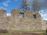 |
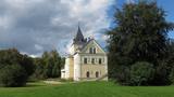
Work on the Valmiera Castle began in 1283. The castle was burned down in 1702 during the Great Northern War, and the city’s walls were torn down in the late 17th century. Ruins of the castle and remnants of other Medieval fortifications have been preserved.
|
|
 |
Saimniecība “Lejaskroķi” atrodas Abavas senlejā. Tajā nodarbojas ar truškopību. Saimnieku aprūpē ir ap 500 trušu, kā arī kazas un mājputni. Viesojoties saimniecībā, viesi varēs samīļot un pabarot trusīšus, kā arī apskatīt kazlēnus, kam ļoti patīk cilvēku uzmanība. Dzīvnieciņus iespējams apskatīt, iepazīt un samīļot, kā arī pabarot. |
|
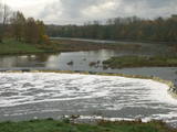 |
The recently renovated old brick bridge and the viewing area that is on the left bank of the Venta beyond the castle guard’s hut offers a lovely view of the widest and most impressive waterfall in Latvia – the Venta falls. It is worth visiting during the spring floods, when fish are migrating.
|
|
 |
Jānis Čakste (1859-1927) was Latvia’s first president (1922-1927), and he began to build a house for himself in 1924. In 1999, in honour of the 140th anniversary of the president’s birth, an exhibition was unveiled about his life, work and family. Čakste’s office can be toured, and artists from Jelgava exhibit their works at the museum, as well. |
|
 |
Latgalisko tradīciju un prasmju māja “Ambeļu skreine” ir latgalisko vērtību glabātāja un popularizētāja. Interesentiem tiek piedāvātas interaktīvas aktivitātes latgaliešu kultūras garā, dažādas meistarklases. “Ambeļu skreinē” tiek svinēti gadskārtu svētki un izkoptas dažādas amatu prasmes. Te notiek danču vakari, dziedāšana, zīlēšana, tiek cepta maizīte, siets siers un tiek veidotas tautas lietišķās mākslas izstādes. No mājas paveras brīnišķīgs skats uz Višķu ezeru un Latgales krāšņajām dabas ainavām. |
|
 |
The Lutheran Church of St John in Aizpute is on Beidas Hill, which is near the steep river valley of the Tebra River and the Dzirnavdīķis pond which the river has created. The church is on an ancient Courlandian castle hill. The current Gothic appearance of the church dates back to 1860, when it was rebuilt. The tower dates back to 1730. This is one of the oldest churches in Kurzeme, and it features an interesting interior with many artistic monuments. |
|
 |
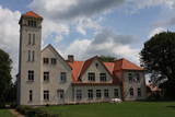
The museum is in the mansion of the Dole Estate, which was built in 1898 for the Loeuwis von Menar dynasty. The collection presents Daugava as an important water route, with the apparel of Baltic and Liv tribes, everyday objects, etc. Outside the movement is equipment to catch lampreys and a reconstructed weir to catch salmon. Alongside is a 17th century cannon from the Duchy of Courland that was found in the Misa River and was cast in Baldone. Nearby are four cannons from the Russian tsar’s army. Those were found on a building lot in Salaspils in 2007. |
|
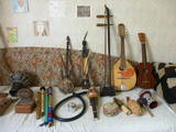 |
The craftspeople use natural materials to produce rattles, wind chimes and musical instruments. They teach children how to make pipes out of reeds. Aleksandrs has a collection of some 100 different instruments which he knows how to play. You can commission or purchase products from the craftspeople. |
|


