
| No | Name | Description |
|---|---|---|
 |
Netālu no augstākā Latgales augstienes paugura – Lielā Liepukalna atrodas zemnieku saimniecība, kuras darbnīcā amatnieks Jānis Kuzminskis taisa mūsdienīgas ģitāras u.c. mūzikas instrumentus. Apmeklētāji var iepazīt Jāņa veidoto ekspozīciju, vērot amatnieka darbošanos, pasūtīt sev jaunu instrumentu, kā arī muzicēt pie bagātīgajā kolekcijā savāktajiem instrumentiem. Saimniece stāsta par Latgales kulinārā mantojuma ēdieniem un rāda, kā gatavo gulbešnīkus. |
|
 12 days
|
The route includes some of the most authentic local expediencies travelling through blue lake districts along the Eastern part of Latvia and Lithuania. This is a region where mass tourism has not yet arrived, and you find very sincere and hospitable people, traditional villages, many churches and cult locations which bring together paganism, Roman Catholicism, Lutheranism, Russian Orthodoxy and Old believers, |
|
 1 day
|
This tour is suitable only for experienced hikers. The itinerary circles the Suurupi Peninsula where the dense forests conceal the military heritage of different eras. The Baltic Coastal Hiking Route meanders through overgrown and rocky seacoasts, birch groves, along former pioneer camps and sand-stone cliffs protecting coves with sharp capes. At the end of the itinerary, one of the most astounding outcrops of the Estonian littoral rises before your eyes – the Rannamõisa Cliffs, which gives views of Kakumäe Bay and Peninsula and the towers of Tallinn’s Old Town |
|
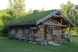 |
The ancient sauna house is a great place for rest and relaxation in Hiiumaa. The house is built of thick logs and has a sod roof. The house has a sauna. |
|
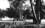 |
Vannūzis (Bath) – A building of the five-building complex “Kurhaus”. During the times of the Neibāde resort, this small building used to be a bath place. In order for the guests of the resort to be able to take a dip in the sea water even in bad weather, barrels of water were delivered by horses to the bath place. |
|
 |
The word “Luitemaa” means “land of the dunes” in Estoninan. This coastline territory stretches for 13 km between Vöiste and Häädemeste with shallow waters, large coastal plains, Estonia’s highest dunes, and the Tokuse swamp (Tokuse raba). There are lots of birds here.
|
|
 |
Guriliški Old-Believers Prayer House was built in the beginning
of the 20th century. It has a very old bell that was made in 1939.
|
|
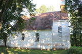 |
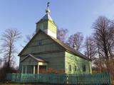
The Zasa Lutheran Church is in the northern part of the Zasa park, was built in 1750, and is a small Lutheran church. The organ, which was produced by the distinguished organ builder Andrejs Sūnākslis, was recently restored. The graves of German soldiers who fell during World War I are near the church. |
|
 |
Taka, kas izveidota Lemmjegi (Lemmjõgi) un Raudnas (Raudna jõgi) satekas vietā, iepazīstina ar palieņu pļavām un veciem pārmitriem mežiem, kas ir vieni no lielākajiem Igaunijā. Takas sākumā dominē atklātas lauku ainavas. Viens no 4,9 km garās lokveida takas apskates objektiem ir Lemjē dižozols. Mitrā laikā noderēs ūdensizturīgi apavi. |
|
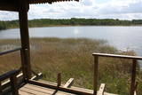 |
This is on the north-western shore of Lake Lielezers of Limbaži, at the start of the Lielezers nature trail. The tower opens up a view of the lake and its lovely shores. It is worth walking the trail, which is several kilometres long, because it is an interesting one. This is part of the ZBR. |
|
 |
Viitna Tavern is one of the few 19th C tavern and post station buildings preserved in Estonia to date. Originally landlords and other rich folk had their rooms and a horse stable in the building’s left wing; today it is a canteen and Estonian handicraft shop. The right wing was for peasant folk chambers and a stable; today it houses a restaurant featuring national dishes on its menu. |
|
 |
This restaurant-burger shop specialises in 100% Latvian beef burgers, selected pizzas and natural french fries. |
|
 |
Ein schönes Holzhaus (Baznīcas ielā 7), gebaut 1670 an der sogenannten Venedig-Brücke in Kuldīga über den Fluss Alekšupīte. Auf dem Dach des Hauses befindet sich eine der ältesten und schönsten Windfahnen der Stadt. |
|
 |
Farm Maizes māja near Cēsis, where you can gain joy, strength and vitality! This tourism farm offers cognitive and educational programmes for adults and children, introducing them to the traditional Latvian lifestyle and intangible cultural heritage. At Maizes Māja, groups of students, families, friends, and tourists become members of the family and have a lot of work to do, for example, bringing firewood and firing the oven, before baking rye bread or sweet and sour bread from Kaupo rye flour in a proper bread oven. When the work is done, a nice meal is enjoyed together. |
|
|
|
The Eversmuiža Estate is in the centre of Cibla and is dominated by a 1680 mansion that was built in the style of Classicism and was rebuilt several times later. There is a home for servants, a gatehouse and ancillary buildings that are in poor shape. A stone wall surrounds the park of the estate. Since the 17th century and for nearly two centuries, the estate belonged to an aristocratic Polish family, after it was owned by various others. Today the mansion houses a boarding school and the Cibla Regional Research Museum, which offers tours. A cultural and historical trail runs along the banks of the Ilža River. |
|
 |
The farm produces tomatoes, cucumbers, strawberries, grey peas, herbs, pumpkins and cabbages, and it also has a group of chickens which spend their time outdoors. The farm’s products are available for purchase. |
|
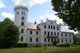 |
Skaistā ēka atrodas Lizuma centrā. Lizuma muižas īpašumi piederējuši dažādām dzimtām – vācbaltiešiem Tīzenhauzeniem, Malamiem un Volfiem. 1836. g. muižu iegādājas barons Otto Gotlībs fon Volfs, kura laikā muižas pils iegūst tagadējo veidolu – Tjudoru neogotikas stilu ar poligonālu torni. Jau no 1937. g. pilī izvietojusies Lizuma skola, kas ir viens no iemesliem, kādēļ saglabājusies ne tikai pati ēka, bet arī atsevišķi interjera elementi kāpņu telpā, Zilajā (Mednieku) zālē u.c. Pili ieskauj parks, kur atrodas muižas saimniecības ēkas – mūra klēts (te kultūras nams), 1876. g. celtais zirgu stallis (sporta halle), kalpu un dārznieka namiņš u.c. Bijušajā spirta brūzī ražo Gotiņas konfektes. Pils tornī izveidots Lizuma vidusskolas veidotais novadpētniecības muzejs. |
|
 |
Café Pärnamäed is located near the highway Via Baltica 10 km from Pärnu, in the direction to Riga; it specialises in baking pastries, white bread and rye bread without preservatives, and also offers products from various small manufacturers. In the café you can also enjoy soups, main courses and desserts. |
|
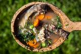 |
You can learn how to cook fish soup here, and the recipes are based on hundreds of years of fishermen's traditions in the Upper Aukštaitija region. You'll learn all about local dining traditions, local lifestyles and traditions since the 13th century. You can go fishing, as well as mushroom and berry picking. |
|
 1 day
|
Dodieties ekskursijā, lai gūtu ieskatu lauku profesijā un dzīvesveidā, kā arī iegūtu jaunus iespaidus un labu atpūtu visai klasei. Ekskursijas laikā apmeklējiet saimniecību, kuras galvenā specializācija ir piena lopkopība un graudkopība. Pēc tam izbaudiet pikniku Vilces dabas parkā, kurš ir izvietojies Vilces upītes un tās pieteku gravu krastos. Pie Vilces pilskalna atrodas Zaķu pļava – labiekārtota un iecienīta apmeklētāju atpūtas vieta. Tālāk dodieties uz maizes ceptuvi, lai iepazītos ar maizes cepšanas arodu, degustētu un iegādātos maiznīcas izstrādājumus. Ekskursijas noslēgumā apmeklējiet saimniecību, kur audzē graudaugus un kartupeļus, piedāvā apskatīt senu darba rīku un piena pārstrādes iekārtu kolekciju un praktiski darboties ar tiem. Bērni var atpūsties un pavadīt brīvo laiku atrakciju parkā. |
|


