
| No | Name | Description |
|---|---|---|
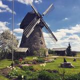 |
The windmill is on a hill and offers a lovely view. This is one of the few Dutch-type windmills (built in 1852) to still be in operational order, and guests can help to grind grain. On the last Sunday of every July, the windmill organises a celebration in honour of St Jacob and of bread baked from freshly harvested rye. Latvian cuisine: Miller’s lunch – wheat flour porridge with meat sauce, crepes, kefir, herbal teas. |
|
 |
Alises Zariņas bioloģiskā saimniecība nodarbojas ar kazkopību. Pašlaik ir divdesmit slaucamas kazas un no to svaigi slauktā piena tiek gatavots siers. Saimniecība dibināta 2015. gadā. |
|
 |
This is an ecological and biodynamic medicinal plant farm that is run by two sisters who produce herbal teas and spices. Educational programmes offer information about the plants and their medicinal properties. You can lease bikes to ride down the bike paths of the Žemaitija National Park. |
|
 |
The saloon is in the former home of the governor of the Koknese Estate. It is named after the Latvian author Rūdolfs Blaumanis, who studied at the estate and lived there for two years. There is an outdoor terrace, and it is possible to hold celebrations there. Latvian cuisine: Potato salad, herring salad, bean salad Valmiera salad, beef with onions, pork ribs, homemade steak haché, roast beef with horseradish sauce, baked liver, herring with cottage cheese, oatmeal dessert. Special foods: “Saloonkeeper’s slice”. |
|
 |
Forts were built and rebuilt at this location for many centuries by Germans, Swedes and Russians. In 1912, several forts were erected at Mangaļsala and Bolderāja. There were two forts with 254-mm cannons, six with 152-mm cannons, and three with 138-mm cannons. Each fort had two cannons.
|
|
 |
A small settlement with a school, library and shop. North from the Vidale are visible remains of the windmill. Going towards the Gulf of Riga, the road crosses Shlitere Zilie mountain precipice with spectacular views during late autumn, early spring and winter, when there are no leaves on the trees and sandstone outcrops. To the left you can see Zilie mountain spring - a landscaped water taking place. Road that runs from the Vidale to Melnsils side, is called by the locals Knipeldambi. They say that it was built by the German army first During World War I, putting logs on the road and covering them with sand. |
|
 |
Atrodas 0,1 km austrumos no katoļu bazilikas. Jau no 1825. g. Svētavota ūdeni izmantoja dziednieciskiem mērķiem. Līdz 19. gs. 40. gadiem avota ūdens īpašības bija izslavētas tāpat kā Aglonas Dievmātes svētbildes brīnumdarītājas spējas. Tās savulaikapstiprinājusi Viļņas ārstu komisija un Pēterpils akadēmija, taču ap 1840. g. avots savas īpašības esot zaudējis. Tomēr arī mūsdienās svētceļnieki joprojām tic avota spēkam. |
|
 |
Palanga is known to be the biggest by-the-sea resort in Lithuania because of its seacoast's main attractions - dunes and white sand. And because Palanga is a resort there are plenty of cafes, restaurants, bars and more for those who would like to enjoy a meal or a drink, for those who like active sport - there is possibility to cycle, go horseback riding, swim and much more. |
|
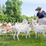 |
A Latvian traditional farm with a herd of some 150 goats, offering tours of the farm and cheese for sale. They offer also home-made ice-cream from the goat milk and a soup made on open-fire. Also latvian traditional sauna is available. The products can also be bought at the little market in Straupe. |
|
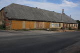 |
Atrodas Sakas un Liepājas ielas krustojumā. Ēka, kas šobrīd atrodas sliktā stāvoklī, celta 19. gs. vidū. |
|
 |
A fish processing plant which has collapsed down to its foundations (it
ended operations in 1978)
|
|
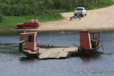 |
In the southern part of Līvāni, where Zemgales Street ends at the Daugava River, there is a fairly unusual and exotic form of transportation – one of three river crossings in Latvia. Unlike the one in Līgatne, this one is operated by a motor, not the flow of the river. It involves a cable across the river, and it is based on Soviet military pontoons that were used to build pontoon bridges for tanks. The crossing point was established by its owners. |
|
 |
Piedāvā ļoti gardus Lietuviešu tradicionālos ēdienus. Var pieņemt līdz 80 personām. Pieņem bankas kartes, pieejama autostāvvieta. |
|
 |
The Kaigari farm is in the Mežotne Parish of the Bauska Administrative District and specialises in grain farming. The farm makes active use of EU funding, some of which has been used to buy modern agricultural equipment. The farm has some 400 ha of land, and the apple orchard offers a very beautiful landscape, including the Lielupe River valley. |
|
|
|
Gebaut als ein Gebäude des Festungstyps. Wurde in der Zeit des Livländischen Kriegs und des Nordkriegs zerstört. 1865 wurde der heutige Turm gebaut. Die von J. V. Rabe gebaute Kanzel mit Spindeltreppe. |
|
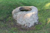 |
The Pinnu (Dievekļa) Sacrificial Stone is at Ulmale, some 300 m from the Liepāja-Ventspils highway (there are signs). This is a very beautiful and distinct bowl-type rock, and the indentation at the top is 15 cm deep and up to 61 cm in diameter. It is thought that this was an ancient cult location, particularly between the 16th and 18th centuries. |
|
|
|
The cave, which is 45 m deep and up to 5.5 m wide is found on the right bank of the Strīķupe river, by the Cēsis-Lenči road. The cave and its nearby sandstone cliff have suffered much damage from local visitors, which is why the administrators of the national park limited access to the surrounding territory a few years ago. You can no longer approach the cave. This is a positive example of who an important geological monument and a protected biotope can be protected. |
|
 8 days
|
The route brings you to Kaunas, multiple Lithuanian regional parks and allows to enjoy the landscapes of the river Nemunas. Kaunas is Lithuania’s second largest city. It is notable for its modernist architecture. The city is located at the confluence of the two largest Lithuanian rivers: Nemunas and Neris. Moving further from Lampėdžiai to Vilkija, the Forest Trail runs for two days along trails and small countryside gravel roads next to the right bank of the river Nemunas. This section is shaped by beautiful landscapes with views of the river, the waterfront meadows and small villages. Do not miss the ferry in Vilkija crossing over the river Nemunas, one of the few still in operation in the Baltic States. For the next two days from Vilkija, the Forest Trail runs through its most spectacular sections in the Dubysa Regional Park from Kirkšnovė to Šiluva with mounds on riverbanks and historical churches now and there. This regional park covers the impressive Dubysa river valley, which reaches a depth of 40 m and a width of up to 500 m. Be prepared for a rolling terrain. Next, the route will take you to the town of Šiluva – the Catholic pilgrimage site – and to the Kurtuvėnai Regional Park. It is among the most forested areas of Central Lithuania; thus, the regional park with its glaciated valleys is a wonderland of forests, waters and wetlands. The Forest Trail leads along small forest paths, tourist trails, beautiful tree alleys and wetlands. The walk ends in Šaukėnai village, from where the city of Šiauliai is easily reached. |
|
 3 days
|
Это один из 6 маршрутов путешествий в серии «Насладитесь деревней!», который приглашает Примерное время прохождения маршрута: четыре – пять дней, в зависимости от количества выбранных достопримечательностей и времени, отведенного для их осмотра. |
|
 |
The restaurant and deli is located in Cēsis, on the way from Valmiera. Modern interior, relaxed atmosphere and delicious dishes from the produce of local farmers. The menu is rich not only with meat and fish dishes, but also with a wide range of vegetarian dishes. |
|


