
| No | Name | Description |
|---|---|---|
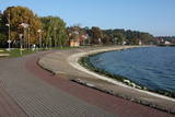 |
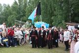
The most populated place in The Curonian Spit - old curonian village - Nida. Until 19th century Nida's citizens were mainly fishermen. Later it became a popular resort. Like other villages here Nida has been "moved" because of "wandering dunes". There are a lot of museums to see. During tourism season there is around ~ 200 000 – 300 000 tourists here.
|
|
 |
Maza apdzīvota vieta ar dažām viensētām uz pussalas (salos tulkojumā no lietuviešu valodas nozīmē „sala") starp vairākiem ezeriem. Salos II ir viens no sešiem Augštaitijas nacionālā parka etnogrāfiskajiem ciemiem. Ciems patiks tiem, kas meklē ļoti nomaļas vietas ar vecām guļbaļķu dzīvojamām un saimniecības ēkām. No Salos II pa sauszemes maršrutu var doties pārgājienā līdz Ladakalnim un Ginuču pilskalnam (sk. iepriekš). |
|
 |
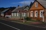
A small town on the way from Riga to Bauska. Town's name is first mentioned in written sources in 1492. Here you can see Lutheran Church and former Manor Park |
|
 |
A small settlement with a school, library and shop. North from the Vidale are visible remains of the windmill. Going towards the Gulf of Riga, the road crosses Shlitere Zilie mountain precipice with spectacular views during late autumn, early spring and winter, when there are no leaves on the trees and sandstone outcrops. To the left you can see Zilie mountain spring - a landscaped water taking place. Road that runs from the Vidale to Melnsils side, is called by the locals Knipeldambi. They say that it was built by the German army first During World War I, putting logs on the road and covering them with sand. |
|
 |
The Old Town of Kandava is located around the old Market Square and dates back to 1881, after a fire in the town. The urban environment in Kandava is made up of farms with various buildings, closed yards, passageways and walls made of fieldstones. These can be seen in Talsu Street and Sabiles Street. Uncommon for Latvia is Lielā Street. At the foot of the Bruņinieku Castle Hill is a model of the Castle of the Livonian Order that was created in 2010. |
|
 |
The central part of the town of Krāslava is an historical monument because its low-story and beautiful wooden buildings. The best views of the historical centre relate to the carp park near the Adamova trail, the Karņicskis hill, the bridge across the Daugava (Prospekta Street), and the Priedaine viewing tower on the left bank of the Daugava River. |
|
|
|
Ein einzigartiges Örtchen beiderseits des Flusses Minija, wo der Fluss eine „Hauptstraße” ist. Litauens Venedig. |
|
 |
In a document from 1387, the village is named Minor Irva. Until the mid-20th century, Mazirbe was the largest Livonian village on the coast of Kurzeme. It was a fishing village and a centre for fishing. The village had a church, school, pharmacy, forestry company, several stores, a post and telegraph office, train station, barber shop, bakery and photo workshop, as well as a brick kiln. During the 1930s, a local fishing co-operative built a fish processing plant here. The Livonian Association was established here in 1923, and the Livonian People's Centre was opened in 1939. Oppoite the centre is the Stūrīši homestead (the home of the Taizel dynasty), where you can learn about everyday household objects and, by ordering it advance, taste local foods. The first chairmen of the Livonian Association, Kārlis Stalte and Māritņš Lepste, lived in Mazirbe. Cultural worker Kārlis Stalte (1870-1978) spent man years as the verger and organist of a church in Mazirbe. Mārtiņš Lepste was a Livonian language teacher in the 1930s. The former Maritime School building can be viewed from the outside. Some 2,000 students attended the school between 1894 and 1914. During Soviet years, the army had a base here. |
|
 |
It is believed that at the Kezberkalnins of Limbazi has been Lemisele castle of Metsepole Liv district. It is also found in the reports that merchants travelled to this place from the sea by Svētupe and Dunezers until the 16th century. In 1223 Bishop Albert built a stone castle in Limbazi. Like Valmiera, Limbazi became the member of Hanseatic League. At the beginning of 16th century it economic role declined significantly since Svētupe and Dunezers became unusable for shipping. Between the 16th and 18th centuries, the town and its people suffered from wars, diseases and fires. As a result, the population reached its utmost fall - eight people. In the turn of 19th and 20th century and in the beginning of 20th century the economic life of the town was renewed. |
|
 |
In the 15th century, Preili manor became the property of Count Borhs family. Borhs were living here until the 60ties of 19th century. The city itself formed in the first half of the 19th century by fusion of Preili Manor, the village and free village - settlement of traders and craftsman. In the 19th century a luxurious palace was built in Preili and Landscape Park was created. Today Preili is an important economic centre of Latgale (cheese and sewing plants), where t folklore, crafts and Catholicism traditions are fostered. Preili tour in the guidance of TIC employee Irena Kjarkuza is highly recommended. |
|
|
|
Evidence found at Dievukalns tells that Baltic tribes lived at this place 3,000 years ago the, but in 7th and 9th here at the Daugava Livs tribes settled. Bishop of Riga built stone castle at the bank of the river Daugava (first mentioned in the 1229), whose ruins you can see today as well. Lielvarde is an inspiration for such people of cultural awakening time as Andrejs Pumpurs (1841-1902) and Auseklis (1850-1879). During World War I (almost three years Daugava served as front line) Lielvarde was completely destroyed. After the World War II, here, as well as elsewhere in the Latvian territory, begins the establishment of collective farms. During this time Lielvarde became known for another symbol - "Lacplesa" beer. Today Lielvarde is a favourite of travellers, who have chosen to make their route along the right bank of the Daugava. |
|
 |
Mulgima or Mulgi is a cultural and historical region in the south of Estonia. The part of Viljandi county located south of the rivers Raudna and Tenasilma was considered to be region of Mulgimaa. In ancient times, Mulgi farmers were famous for their sharp minds and determination, which helped to buy land from German-Baltic nobles and become rich farmers. The icons of Mulgi culture - the dialect, the well-known men's long black jacket and the traditional Mulgi porridge - have survived to this day. |
|
 |
The historical centre of Talsi, which is known as the town of nine hillocks. The historical construction around Baznīckalns hill, Lake Talsi and Lake Vilkmuiža mostly dates back to the 19th century. Lielā Street is particularly beautiful with its low-rise buildings (two or three floors and ridged roofs). There are beautiful views from the area around Lake Talsi and Ķēniņkalns hill. |
|
 |
Ap 200 m garajā un izstieptās formas laukumā no 16. – 20. gs. atradās Liepājas tirgus. Laukuma malās tolaik bija izveidojusies vienstāvu apbūve – iebraucamās sētas, viesnīcas un dārzi. Līdz ar Pētertirgus izveidi 1910. gadā, izmainījās arī laukuma apveidi un to ieskaujošā apbūve. Laukuma DA malā slejas iespaidīgā Liepājas Svētās Annas Luterāņu baznīca. |
|
 |
Ventspils Vecpilsētas vēsturiskais centrs. Nelielā Rātslaukuma (40 x 60 m) rietumu malā atrodas Starptautiskā rakstnieku un tulkotāju māja, kas ierīkota 18. gs. dzīvojamā ēkā ar baroka un klasicisma iezīmēm (19. gs. vidū te atradās pilsētas Rātsnams), bet austrumu malā – vēlīnā klasicisma stilā celtā evaņģēliski luteriskā Nikolaja baznīca. Iepretim baznīcai atrodas modernā stilā pārbūvētā Ventspils Galvenā bibliotēka un Digitālais centrs, kas ierīkots greznā 19. gs. savrupmājā. |
|
 |
A small settlement on the banks of the River Daugava, between Aizkraukle and Jaunjelgava. Skriveru region is associated with the life and work of popular Latvian author A. Upitis. Near Skriveri lies the oldest arboretum in Latvia. Its establishment in 1891 was started by the owner of Skriveru manor Maximilian von Siverss. In the park there are about 400 plant species, varieties and forms. One of the finest views of the Daugava will open from the so-called Krauklu Mountains – steep upper part of the right riverbank, which is an ancient hill fort. |
|
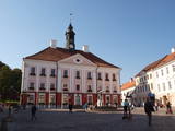 |
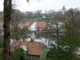
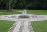
Formed on the left side of river Emajõgi, in the valley of Doma Hill. The centre of The Old Town of Tartu is Town Hall Square with Town Hall and the fountain "The Kiss of the Students" (symbol of the city). |
|
 |
Renda is a very old town, first mentioned in historical sources in 1230. During the 13th century, Renda was one of the centres of the ancient Courlandian land of Vanema. When Courland was split up in 1235, Renda was taken over by the German Order, and local residents were forcibly drafted into its military. During the age of the Duchy of Courland (1562-1795), the region flourished despite wars, the bubonic plague and other problems, particularly during the rule of Duke Jacob (1642-1682). During the 17th century, Renda became something of a manufacturing centre, churning out timber products, with local lime kilns, watermills, flax weaving facilities, a glass factory and a boiling house for saltpetre and soap. Wine, perfumes and barrels were produced in Renda, as was cast iron for nails and many other things. The court at the Jelgava Castle loved the sour wines from Renda. All of this was destroyed during the Great Northern War (1700-1721). During the 19th century, a chemicals factory was built on the site of the burned Renda castle, and nearby was one of the largest leather tanning plants in Kurzeme, along with a manufacturing facility for turpentine. Cultural life began to develop in parallel to this. Renda suffered much during the two world wars and the subsequent Soviet repressions. The so-called Courelian Battalion of partisans went into the forests after the occupation to continue their struggle against the Soviet regime. Renda today is a small and quiet village with the Lielrenda Estate, a local church, the “devil’s boat” at the Abava River, and the Īvande waterfalls. |
|
 |
Saldus is mentioned in the historical documents already in 1253. Until the 13th century an ancient Cours castle Salden was located here, which is also represented in the coat of arms of the town. Around the 1341 Livonian Order built a castle near the Cours hill fort, where settlement formed. Its peak of development, like the other settlements of Courland, was during the reign of Duke Jacob 1642 – 1682. 1856 is mentioned as the year of the foundation of Saldus, when restoration of town perished during the Northern War begun. At the end of the World War II a big fights took place at the town, but town remained in German-occupied part of Latvian until the May 8, 1945. Modern Saldus attracts with its activities - town days, the music festival "Saldus Saule", as well as a variety of sightseeing objects, among which A/S 'Druvas Partika" can be mentioned, where you can watch how the ice cream is made and Saldus Food Factory, where you can taste the delicious candy "Gotina" and watch the production process. |
|
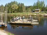 |
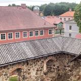
Ligatne history is inextricably linked to Ligatne paper mill. At the end 19th century and beginning of 20th century here was built houses, schools, maternity homes, hospitals, clubs, guest houses and other buildings for workers that have survived to the present. During the Soviet period Ligatne mill produced mainly school exercise books, which was sent to all the Soviet republics. Nowadays, the main raw material is recovered paper used for production of wrapping paper. Ligatne paper mill is the only one functioning Latvian company of this kind, and it can be explored with a local guide. Historic centre of Ligatne paper mill has been awarded the status of cultural monument. In the northern part of Ligatne - Gauja river bank the only functioning Gauja river ferry can be found and the only river ferry in the Baltic States, which is powered by river current. The ferry is vehicle of local scale. In the west of Ligatne, Ligatne nature trails are located; where close to natural environment conditions (the best object of this type in the Baltic States) lives red deer, roe deer, wild boar, fox and lynx. Within the territory of Ligatne nature trail a dense network of hiking trails and paved road - cycling route has been created, during the winter it becomes a cross-country ski track. A modern visitor centre is available here. East of Ligatne at Ligatne rehabilitation centre a unique place on the Europen scale can be found - a former Soviet secret bunker that was built as the main living and working place of Latvian senior military and civilian persons in case the nuclear or chemical weapons were used. Bunker was opened in 2003; therefore it remained intact to this day. On the way from Augsligatne to Ligatne go to see Vienkoci Park, where you can explore boats made of single wood peace by the creator of Park Richard Vidzicka, look at the different building models, sand home, and participate in themed activities. |
|
