
| No | Name | Description |
|---|---|---|
 |
The craftspeople offer tours during which you can watch them at work. You can also produce your own souvenirs with various techniques, including the potter’s wheel and the engraving technique, making use of pre-prepared moulds. You can also commission and purchase ceramics products. This location is popular among children and wedding parties. |
|
 |
Saimniecība nodarbojas ar zirgkopību un aitkopību. |
|
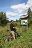 |
Taka veidota gar Gaujas labo krastu augšpus un lejpus Gaujienas un tā iepazīstina ar nogāžu mežu un dažādu pļavu biotopiem. Visā tās garumā izvietoti informatīvi stendi. Takas daļu lejpus Gaujienas var braukt ar velosipēdu.
|
|
 |
The organic farm Zemturi is a 30 min drive from Kuldiga. The farm is mainly engaged in breeding rabbits and is designed as a place for children to see, learn about rabbits, birds and other pets. The hosts have created two thematic trails, one for pets and poultry and the other for trees and flowers. Sauna lovers have access to the sauna, also fishing opportunities can be used. Overnight stays with family or a small group of friends are also offered. Excursions for big and small. |
|
 |
Pitas ir pēc inovatīvas žāvēšanas tehnoloģijas radītas augļu, ogu un garšaugu garšvielas, kuras ražo mājražotāja Lorita Miķelsone. Mājražotāja labprāt ļaus nodegustēt un iepazīstinās ar Pitām jebkuru interesentu, uzņemot apmeklētājus Skaisto un praktisko ideju dārzā Dobelē. |
|
 |
Home restaurant on Kihnu Island, where owners make rich meals, using the island's local ingredients, mainly fish. |
|
 |
You can access ÕUNA farm (ÕUNA puhketalu) by Piibe Road, behind the old horse post and pub. Here you can spend the night, have some food and enjoy various entertainment activities. Menu includes only Estonian national foods. |
|
 |
Guesthouse "Stikāni" is located in Rezekne district. The guesthouse has four comfortable rooms for two people and a dining room with an exit to the garden terrace. A knowledgeable guide will take you to the nature trail where you can learn about typical trees and bushes, popular and less known medicinal plants, nesting birds (during the summer) and impressive bird migration during the spring and autumn. |
|
 5 days
|
This route involves unique views that have never been seen before in Latvia! The impressively steep shoreline of the Baltic Sea begins a few kilometres to the North of Pāvilosta and ends shortly before Ošvalki, stretching for nearly 20 kilometres in all. Its most impressive and unusual forms are seen between Strante and Ulmale. The entire route leads down the western boundary of the former Iron Curtain, because the Baltic Sea coastline was militarised during the Soviet era and unavailable to most people. Remnants of former military objects and old tank routes in the dunes can still be seen. The largest biotopes of grey dunes stretch for several kilometres around Ventspils and Užava. These are unusual landscapes that can seldom be seen elsewhere in Europe. You can walk more than 10 kilometres here and not see another soul. Route information from Latvijas Lauku forums |
|
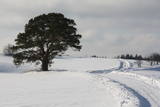 |
This is an unusually shaped pine which, according to legend, was planted by the king of Sweden during the Great Northern War.
|
|
 |
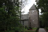
One of the biggest castle hills in Estonia, which is surrounded by walls built of stone. It is mentioned in Livonian Chronicle of Henry as one of the best fortifications at that time. |
|
 |
This trail's purpose lies on the fact that herbal therapy is the oldest known system of medicine. Being outside, in fresh air, in nature affects our health positively. While hiking with a phytotherapist you will get to know more about the nature's wild herbs that can help our livelihood and also do some light exercises. If you want, you not can only walk the trail but also relax in a sauna or/and visit a workshop. |
|
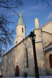 |
The first wooden church was built here in 1252, and the brick church was built in 1665. It burned down and was restored in 1672, but it was rebuilt in later years. There are important artistic monuments in the interior of the church – the altar, the pulpit and the painted organ. Legendary Duke Jacob Kettler of Courland (1610-1682) was baptised in the church and married Princess Charlotte Louise from Brandenburg in it. During the Soviet era, the church housed a museum and a concert hall. According to legend, the name of the church is based on a woman called Catherine, who donated funds to build the church, was subjected to lies, tortured and then proclaimed as a saint. Above the side entrance is a medallion of a woman with a crown of thorns, torture equipment and a sword in her hand. Elements of this story can also be seen in the herald of Kuldīga. The steeple of the church offers a good look at the roofs of the ancient part of the city. |
|
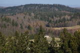 |
This park was set up to protect the landscape and cultural environment of the Haanja highland. At the central part of the park are the two highest hills in the Baltic States – Suur Munamägi, which stands 318 m above sea level, and Vällamägi, which is 304 m above sea level. The ancient Rõuge River valley (Rõuge ürgorg) is found in the western part of the park. It is 7.5 km long and up to 60 m deep. The valley dates back to the Ice Age, and it has seven lakes, including the deepest one (38 m) in Estonia – Lake Rõuge Suurjärv.
|
|
 |
1.2 km to the south of the centre of Ģipka and on the side of the Jūrmala-Kolka road (P131), this church makes it hard to believe that the rock church was built very recently – after 1992, because it was burned down during the Soviet occupation in 1979. Ironically, the Dundaga forestry fire safety post was housed in the steeple of the church after World War II. The ornate altar and organ were destroyed in the fire, but the altar painting, “Christ on the Cross,” was saved. The church is now once again open for business. |
|
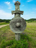 |
Embūtes dabas parks, saukts par Embūtes senleju, ir viena no skaistākajām, interesantākajām un noslēpumainākajām Kurzemes vietām. Nav Latvijā otras tādas vietas, kur ieejas vārtus dabas parka teritorijā simbolizē stilizēti zobeni ar vairogiem ceļa abās pusēs, radot mītisku un cienījamu noskaņu. Par Embūtes apkārtnes vēsturi stāsta daudzas teikas un leģendas. Viena no pazīstamākajām ir romantiskā teika par kuršu vadoņa Induļa un vācu komtura meitas Ārijas mīlestību. Vietā, kur viņi pirmoreiz tikušies joprojām atrodas Ārijas un Induļa ozoli. Embūtes dabā parkā ieteicams apskatīt - ekotūrisma taku, Embūtes viduslaiku pilsdrupas, Embūtes luterāņu baznīcas mūrus, Induļa pilskalnu, Pilskalna avotiņu, Induļa un Ārijas ozolu. Dabas parks aprīkots ar labiekārtotu pastaigu taku, skatu platformām, skatu torni, labierīcībām un atpūtas vietu. |
|
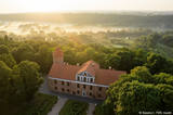 |
The Raudondvaris Castle is on the right bank of the Neveža River in Raundondvaris. The estate and a park that covers 3.8 ha has two buildings, an orangery, a stable for horses and a cellar. Alongside the estate in 1834 was a park that was rebuilt in the 20th century with new plants and flowerbeds that featured ancient types of roses. The northern part of the park is forested, with maple, pine and linden trees, as well as Edelweiss that blooms in the spring. Paths in the park lead to a local environmentally protected area. |
|
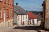 |
Kandava is first mentioned in the articles in 1230. In 1253 the Livonian Order built a stone castle at the upper part of Abava valley shore, at the foot which of an urban area formed. In the 17th century Kandava became an important trading centre. The plague epidemic and developments of World War I hit the town and its people hard. Kandava got the town rights in 1917. During soviet Soviet times, Sports Complex of Jaunkandavas agricultural Technical School became a popular training venue. |
|
 |
A former manor barn, located by the lake in Raiskums, 8 km from Cēsis, where bread and beer is made. Offers beer brewed according to ancient traditions, bread and smoked meat prepared following the recipes of ancestors. Bread is cooked in a wood oven with natural sourdough. The special taste is obtained in the wood-fired beer brewing pot and old countryside bread making oven. Guided tour and tasting. |
|
 |
Nordeķu - Kalnciema kāpu grēdas daļa Kleistu meža austrumdaļā pie Dzirciema ielas. Padomju laikā šeit darbojās divi (vēlāk viens) P - 35 radars, kas griezās ap savu asi. Vietējie iedzīvotāji tolaik šo vietu bija iesaukuši par "Lokatoru kalniņu". Ziemeļos no tā atradās padomju armijas cūku ferma. |
|


