
| No | Name | Description |
|---|---|---|
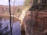 |
The viewing area on the Ērgļi (Ērģeles) cliffs offers an impressive view of Latvia’s most monolith sandstone cliffs (up to 22 metres high) – this is the highest location in the Gauja River valley. Please be very careful and don’t go anywhere near the edge of the cliff!
|
|
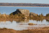 |
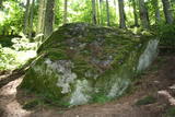
Trīs lielāka izmēra laukakmeņi – aizsargājami dabas pieminekļi, kas atrodas Matsalu līča krastā starp Sāstnas (Saastna) un Metskjulas (Metsküla) ciemiem. Tuvējā ceļa malā ir izvietots informācijas stends un norādes, bet līdz akmeņiem var nokļūt pa iezīmētu taku. Pēc kāda tautas nostāsta, lielas vētras laikā, kas notikusi Jaungada naktī, lielais akmens sašķēlies trīs daļās. No tā arī cēlies vietvārds. Apkārtnē redzamās pļavas ir nozīmīga daudzu augu sugu dzīves vide un svarīga putnu ligzdošanas un atpūtas vieta. Šī iemesla dēļ taku drīkst apmeklēt tikai no 1. jūlija līdz septembra beigām. Akmeņi ir arī labi redzami no minētā ceļa. Tie ar ledāju atceļojuši no Turku (Somija) apkārtnes. |
|
 |
Another coastal defence battery was sited about 1,500 metres to the East of Lūžņa, where the Lūža River flows into the Baltic Sea. Remnants of Soviet-era buildings can still be seen there.
|
|
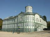 |
Jurmala town (the second largest in Latvia) was founded in 1959, by combining Kemeri and Sloka towns in the Riga city Jurmala district. It stretches 32 km along the coastal line of Gulf of Riga. Jurmala resort once was one of the most important objects of this type in the Northern Europe. This was facilitated by the development of local and interstate transport and traffic (coaches, steamers, train). The first guests was accommodated in Dubulti, where in 1834 the first hotel was built, but in 1847 - The first wellness centre. In the 19th the first medical institution launched. Starting from 1834 the rapid construction of summer cottages began. Development of the resort was ended by the World War I. After the war the number of resort vacationers boomed from 12 thousand (in 1920) to 32 thousand (in 1935). Kemeri resort developed along with Jurmala, which received a massive of vacationers' amount during the Soviet period. |
|
 |
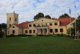
The Lutheran Church of Krimulda is considered one of the oldest churches in Latvia. It was originally built in the 13th century, soon after the conquest of Kubesele and later rebuilt many times. Near the church a meditation labyrinth "Lily Flower" is set up. When Liv chief Kaupo fell during the battle at Viljandi in 1217, according to the legend, the ash was buried at the church. A small hill adjacent to Runtinupite (Runtins) is popularly known as a grave site of Kaupo, at its right bank is located ~7 m long, artificially dug Kubesele or Runtin cave. On the left bank of Runtinupite columns the Kubesele hill fort. Kubesele nature trail starts at the church. This trail leads to the Gauja River, where the Great (Runtina) stone lies. Here can be seen anchor pads installed by Gauja raftsmen. Krimulda medieval castle (4 km east of Krimulda Church) was built the second half of the 13th century in the place where the right bank of Gauja valley is split by deep ravine of Vikmeste. Castle (residence of Riga dome capitol - Riga's Archbishop Council) was an imposing building, whose big inner yard was included by 1.5 m thick defensive wall. In 1601, while retreating, Swedish military leader Heinrich Lieven blasted Krimulda castle. Now at the hill fort, grown with the forest a small castle ruins can be seen. Nearby is located air cableway and starts Krimulda mountain road. Located nearby Krimulda manor was first mentioned in writings in the 15th century. Present manor castle was built in the 19th century in neoclassical style (owner - First Lieven). During the twenties of the 20th century, the castle after its alienation became a property of the Latvian Red Cross, which established here children's sanatorium. Nowadays the castle houses rehabilitation hospital "Krimulda", but from the farm buildings, manor stables, barn, servant, manager houses and the so-called Swiss Cottage and Park have been preserved. Thematic tours are offered here. If we go down the Gauja by boat, then we will be able to take a close look at about 15 m high Velnalas cliffs. They can be well seen also from the opposite - left bank of Gauja (resting place is established). In the middle of the cliff about 19 m deep and 4.7 m high Krimulda Velnala cave is located. If we go from the Velnala cave cliffs along the lower part of the right bank of Gauja in Turaida direction, you will see Pikenes cliff, rich with sandstone outcrops. At its foot ~ 1 km long Pikenes beaver trail is established. The Little Devil's Cave (5 m long) is on the side of the trail, with the Gudribas (Wisdom) spring that springs out of the cave, as well as Aunapieres cave which is the same length as Devils cave. Small oxbow lakes also can be seen. |
|
 |
The “backbone” to this park is the valley of the Šventoji (Holy) River. One of the most impressive Devonian cliffs in Lithuania can be seen from the river – Vetygalos atodanga. On the shores of the Varius stream is a cliff made of quartz and sand – Variaus atodanga. 6 km to the S of Anykščiai is Lithuania’s second largest rock (5.7 m high, ~100 m3) – Puntukas akmuo.
|
|
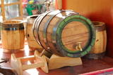 |
The craftsman manufactures barrels, hot tubs, furniture, stairs, doors and other useful objects. You can take a tour, learn about the relevant skills and experience, and help in manufacturing something that will be of use in the household. You can watch how barrels are made from start to finish, and also try your own hand at the craftsmanship. |
|
 |
The cafe in Engure which specializes in different seafood dishes – no fewer than seven types of fish dishes – filets, salads, canapés, fish cakes, marinades, pierogi, etc. Latvian cuisine: Cold soup, marinated lamprey, baked plaice, baked cod, sautéed pork, crepes, potato pancakes. Special foods: Būda solyanka. |
|
 6 days
|
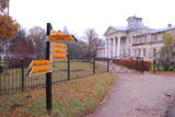
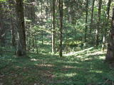
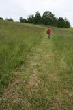
This section of the Forest Trail leads through the entire Gauja National Park and gives an opportunity to see all the most beautiful places and sights of this national park of more than 100 km. Gauja National Park is the oldest and largest national park in Latvia. The ancient valley of the River Gauja is the deepest river valley in the Baltic states. The banks of the River Gauja reveal colourful sandstone outcrops, which are reflected in the water. The sights are most wonderful in springtime, when bird cherry trees are in full bloom, and in autumn, as the trees turn red and yellow. The ancient valley of the River Gauja has a distinctive terrain relief that can fluctuate by up to 80 m. The largest part of the road leads through forest paths, along the river, and exits the woods in Līgatne and Sigulda. Almost half of the park is covered by forest. Gauja National Park is known for the great diversity of specially protected forests, featuring herbaceous spruce forests, slope and ravine forests, as well as mixed broadleaf forests. |
|
 |
Bejas meža dabas liegums veidots no reljefa viedokļa - interesantā, pauguru un starppauguru ieplaku saposmotā teritorijā, kuru klāj vecs un varens egļu mežs. Bejas mežā atrodas viena no Alūksnes rajonā vairākām "Velna pēdēm" - dziļa, krāterveida ieplaka, ko veidojis kūstošais ledājs.
|
|
 |
The café is in the market square of Vecpiebalga, opposite the Lutheran church. It works with local farmers and sells products from a local smokehouse. |
|
 |
Atrodas 0,9 km ziemeļrietumos no Dzērbenes centra. Tagadējais muižas komplekss veidojies 14. gs. celtās un 1577. g. nopostītās mūra pils vietā. Muižas pils (18. gs. beigas, klasicisma stils) savā pastāvēšanas laikā piedzīvojusi vairākkārtīgu nopostīšanu (1905. g., Pirmajā pasaules karā) un tai sekojošu atjaunotni. 19. gs. beigās tai tapa piebūve – iespaidīgs četrstūru neogotikas stila tornis. Laikā no 1927. - 1975. g. pilī darbojās lauksaimniecības skola, tagad - Dzērbenes pagasta pārvalde, Tautas nams un mūzikas skola. Pili ieskauj parks ar septiņu dīķu kaskādi. No kādreiz iespaidīgā laukakmeņu žoga saglabājušies vien pils vārtu stabi. Dažādā stāvoklī (arī avārijas) atrodas citas muižas ēkas. 2010. gadā tika veikta pils iekštelpu un ārējās fasādes restaurācija. Iepriekš piesakoties, tiek piedāvāta gida vadīta ekskursija un piedzīvojums muižā iekārtotajā spoku kambarī. |
|
 |
Viens no iespaidīgākajiem nacionālā parka pilskalniem, kura piekājē atradusies senpilsēta. Arheoloģisko izrakumu gaitā te atrastas kuršu senlietas. Tiesa, mežs un biezais augājs traucē uztvert šī nozīmīgā arheoloģijas pieminekļa patiesos apjomus un formu. Uz pilskalnu vasarās ved izpļauta taka. Ja esat Žemaišu Kalvarijas pusē un atliek brīvs brīdis, tad savā maršrutā var iekļaut arī šo apskates objektu. |
|
 |
Vienu kilometru garā lokveida taka, kas ved pa lielāku nacionālā parka meža masīvu, uzskatāmi attēlo Žemaitijas augstienes un tuvākās apkārtnes reljefa veidošanās vēsturi. No takas augstākā punkta – Mikitai kalna, kas ir sens pagānu upurkalns, paveras (ainaviska stiga) tālākas apkārtnes skats. Kā takas interesantākie apskates objekti ir jāmin teikām apvītais akmens ar Velna pēdu un ar akmeņiem izliktas akas paliekas. |
|
 |
This nature park is located in the most distinct part of the Dagda hillocks of the Latgale highlands. Part of it is the deepest lake in the Baltic States -- Lake Drīdzis, which is 63.1 metres deep and has nine islands. Also there is Lake Otis. The loveliest views can be watched from the ancient Lettigalian castle hill that is known as Sauleskalns, and from the eastern shores of Lake Drīdzis. Accommodations are available near the lake. |
|
 |
Visitors can learn about work from the 19th century, including pottery, which is the oldest craft in the world. You can shear sheep, make beautiful and warm things with the wool, and forge lucky nails and horseshoes. Educational programmes here will be of interest to fans of history and others who want to have a good time. |
|
 |
Temple Hill is steep (with artificially created steepness) and about 30 m high, and it is opposite Marijas Island. It is an ancient Lettigalian castle hill, 80 m long and 40 m wide, with several artificial ramparts. One of the oldest objects found in the region is an axe from the 2nd to 3rd millennium BC. Archaeologists believe that the island was populated at that time. There was a Lettigalian castle on the hill during the 10th and 11th century, but it was sacked by the Holy Crusade. The surface of the castle hill was transformed comparatively recently in 1807, when a granite rotunda was built there in honour of Russian Field Marshall Sheremetev and Swedish captain Wulff. The view of Lake Alūksne and the town is one of the most beautiful ones in all Vidzeme. The Sun Bridge (1937) is also worth a look. A wooden viewing platform is nearby. |
|
 |
The farm offers educational programmes about the specifics of growing hemp, as well as about hemp products. During the programme, visitors are treated to products grown at the farm. |
|
 |
The beautiful wooden building, located right at the entrance of Gulbene, provides a place for guests to have a meal, enjoying the perfect atmosphere for relaxation and well-being. Home cooking and Latvian dishes. |
|
 |
The zenith missile brigade and its communications headquarters were used for the provision, planning and co-ordination of radio communications. The object is all but abandoned, but it is owned by the Latvian Repatriation Centre and the Christian Mission.
|
|


