
| No | Name | Description |
|---|---|---|
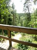 |
This is one of the most lovely and expressive castle hills in Latvia, with a very fine view of territory all the way to Lithuania. According to Ernests Brastiņš, a researcher of castle hills in Latvia, this was the site of the Semigalian Sidrabene castle. There are no improvements in the area.
|
|
 |
Older residents say that the guesthouse is located in the centre of the Domanti village. The guesthouse has four buildings built in accordance with ethnic architectural traditions, including a granary, a sauna and a traditional residence with two ends. |
|
 |
The site of the Oak tree of love, which was
once a symbol of the growth of Ķemeri on the
left bank of the Vēršupīte.
|
|
|
|
Kuģinieku drošībai 1875. g. celtā bāka stipri cieta 1. pasaules kara laikā. Savu tagadējo izskatu tā ieguva pēc atjaunošanas 1922. g. Bākas uguns atrodas 21,3 m v.j.l. un tās detaļas savulaik vestas no Francijas. Pie bākas ieejas 1975. g. uzstādīta piemiņas plāksne par godu bākas simtgadei. Pie bākas atrodas bijušās padomju armijas militārās bāzes atliekas. |
|
 |
"Mākoņmalas" is located in the middle of the forest, in silence. A magical place where you can enjoy SPA procedures and sauna rituals, gain knowledge in magical and non-traditional practices, as well as be alone with nature, improve health, enjoy a "short vacation for the hurried and busy". In "Cloud Edges" you will receive a restart for both body and soul. After the procedures, it is possible to enjoy a deep night's sleep in our home and taste the early breakfast on the terrace, watching the morning rituals of wild animals and the beauty of nature. You can enjoy the morning with a stick or a regular morning walk through the forest to meet deer and other forest dwellers. |
|
 |
Farm "Obelisk" is an industrial hemp farm located in Latgale region, Vilani county. This farm focuses on growing hemp as well as producing various hemp products like oil, seeds, salt, spices and more. There is possibility to learn about hemp and it’s many applications while taking a tour around the farm, joining a workshop or a course, having a group team building event or experience the first and only hemp escape room in Latvia. |
|
 |
Auch Königstor (Kuningavärav) genannt. Im Barockstil gebaut ist ein Teil der früheren mittelalterlichen Stadtbefestigung. Der Beginn des alten Postweges. |
|
 |
The restored mansion of the Dunte Estate is now a museum featuring the adventures and life of the legendary king of lies, Baron Munchhausen. The first floor is devoted to the barn and his stories, while the second floor has a collection of wax models of people who are distinguished in terms of Latvia’s history. Also there is the largest collection of beer mugs in Latvia. There are three circular trails in the forest with wooden sculptures. The longest one leads to the sea. A wooden model of a ship is interesting to children. |
|
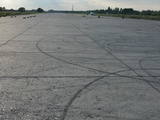 |
The Rumbula airfield was originally a military facility, established after World War II at a place where many single family farms had been before. When the Spilve airfield shut down, civilian aircraft moved to Rumbula, while military aircraft were based at the Rīga airport. Today the world “Rumbula” is most often associated with the automobile and spare parts market that has been established on part of the former airport’s territory. A certain “heritage” at the site is pollution from the former airfield’s fuel containers, where petroleum was stored. Paragliding occurs at the airfield.
|
|
 |
The diner is found in a former church school building. Delicious dishes are made of local ecological produce; local fishermen supply the fish on the menu. Local crafts are on sale in the handicraft shop. |
|
 |
The fast-food place of a bistro type in Gulbene with a tasty lunch menu for very reasonable prices. It is also possible to try dishes typical for Gulbene district here. Working hours: Monday-Friday: 08:00 - 18:00, Saturday: 09:00 - 14:00 |
|
 |
Atrodas pilsētas centrā – Tukuma ledus halles ēkas otrajā stāvā. Piedāvā maltītes visām ēdienreizēm, klāj galdus pasākumiem, īrē telpas dažādiem pasākumiem. |
|
|
|
Another example of a costal defence battery along the Kurzeme shoreline is found here.
|
|
 |
The farm offers visitors an excursion around the garden and wine cellars; it is possible to try wine, as well as buy wine, candy and marmalade. |
|
|
|
Smarde is an ancient place, mentioned in the 13th century documents. Today it is a small village with railway station and shops. Northeast of Smārde - former peat extraction places are located in Smārde marsh. During World War I the front line was near Smārde, the vicinity of which is witnessed by the memorial sites. |
|
 |
You can take a smoky sauna, watch the milking of cows, learn how to milk a cow, buy fresh bread and pastries along with unique apple tea, rent a family tent, take part in farm work, go fishing and swimming in the pond and shoot arrows with old and modern bows. |
|
|
|
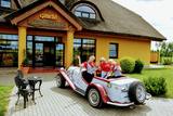
The Smārde saloon has a very long history,
and food is served here. There is a car park, and
approx. 100 m to the East is a cemetery and
monument to commemorate soldiers who fell
during World War II.
|
|
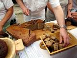 |
"Cēsu maize" is located in the very heart of Cēsis, Riga street 18. Bakery makes bread from organic cultivated grains in Latvia and with natural grass. The offer includes products such as: Spelled whole wheat bread, whole wheat bread with sun-dried tomatoes and olives and spelled sweet bread. |
|
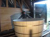 |
The craftsman represents the fifth generation of the oldest dynasty of Latvian barrel makers. The family began such work in the early 19th century, and he is continuing on with traditions related to barrels that are made of oak and ash. He will talk about the various aspects of making a barrel, and you will be able to watch him at work. The craftsman produces barrels, wooden tubs, scoops for saunas, etc. You can order and purchase these items. |
|
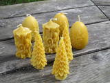 |
This farm is an apiary, with hives of bees gathering honey. The farm has won prizes for its products. You can take a tour and learn about the lives of bees and beekeeping products, make your own wax candles, or attend educational seminars. |
|


