
| No | Name | Description |
|---|---|---|
 |
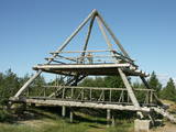
The farm on the banks of the River Navesti is Estonia's largest company engaged in the cultivation and processing of organic medicinal herbs. The farm has an education and health path of medicinal herbs, open from May to September. The Energy Eco-Spa offers holiday, conference and accommodation services with a sauna. Spa experience is with local, ecologically grown herbs together with clay, peat and natural plant oils. Baths, wraps and massages help the body to function naturally and holistically. All the products are natural and fresh and are prepared just for you immediately before the treatment. Farm has a tea house completed in 2010 which is suitable for holding seminars, relaxing and in the summertime also for having meals. Herb presentations are held there - first on the field and then in the tea house. There is also a 13-metre viewing tower by the river from which you can get a good overview of the lands of the farm. |
|
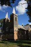 |
В1699 в центре Нюкши Пасиенские доминиканские монахи построили часовню, на месте которой в 1765 году помещик Хилзен возвел новую церковь. Помещения были маленькие, и в 1922 - 1926 гг. на фундаменте старой церкви строится новая и большая – теперешняя церковь, которую называют одним из самых красивейших деревянных храмов Латгалии. В здании находится центральный алтарь работы второй четверти XVIII века и два боковых алтаря работы примерно 1700 г. Церковь можно осмотреть изнутри. |
|
 |
The landlady of this farm will tell you about healthy herbal teas and home-based goodies. If you wish to spend the night under the stars, we offer a place for tents and a campfire on the banks of local river by the old Lūkas windmill. “Aploki” will welcome anyone who wants to relax in a peaceful and quiet atmosphere. |
|
 |
Suhka farm observes old traditions and serves local food. It also offers accommodation in a picturesque location. In addition, here you can learn of hiking routes in places you will not hear about elsewhere. |
|
 |
Materials of archaeological excavations show that the Ogre river banks were inhabited by the Livs. Ogre as a larger populated area and a major resort developed after the construction of Riga-Daugavpils railway in 1861. Until the World War I about 300 cottages offered their services in Ogre, most of them were destroyed during the war. The next "major" event took place 1965 when one of the largest knitwear plants in Europe was built in Ogre, which was staffed by guest workers from Vietnam and countries. Today, Ogre has still not recovered its glory of a resort, but has become a rather exclusive site of mostly low-rise residential buildings. |
|
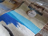 |
The artist’s workshop is in a lovely single family farm. She weaves tapestries, allows visitors to watch her at work, accepts commissions for tapestries, and sells finished ones. Many of her artworks are practical souvenirs or could be fine gifts for others. |
|
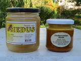 |
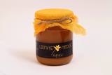
The owner offers honey made of various flowers, forest plants, heather and linden blossoms, pollen, bee bread, propolis, and other beekeeping products. He will be happy to give you a tour and tell you about his work. |
|
 1 day
|
The smoke sauna is an important part of everyday life in the Võru community in Estonia. It is the centre of a rich set of traditions including the actual bathing customs, the skills of making bathing whisks, building and repairing saunas, and smoking meat in the sauna. The sauna is a building or room heated by a stove covered with stones and with an elevated platform for sitting or lying. It has no chimney, and the smoke from the burning wood circulates in the room. People usually go into the sauna together and remain until they are sweating. Water is thrown on the heated stones to produce hot steam-laden air and bathers beat their bodies with whisks to remove dead skin and stimulate blood circulation. After sweating, whisking, relaxing and possible healing procedures, people cool themselves outside and rinse their bodies with water. The procedure is then repeated. The smoke sauna tradition is primarily a family custom, usually practised on Saturdays, but also before major festivals or family events. Its main function is to relax the body and mind. Families take turns hosting each other. Usually an older family member is responsible for preparing the sauna, accompanied by the children who gradually acquire the necessary skills. The smoke sauna tradition is part of the UNESCO Representative List of the Intangible Cultural Heritage of Humanity. |
|
 |
This is the only viewing platform of its kind. It is north of Pāvilosta, between the sea and Latvia’s largest gray dune. The second level of the platform offers a good view of the habitats which surround the dune, as well as the seashore and the largest seashore rock on the shores of the Baltic Sea – the Pāvilosta sea rock. You can also see the northern part of Pāvilosta. When it is windy outside, you’ll see kiteboard riders showing their tricks.
|
|
 |
Līdzmūsdienām ir saglabājusies vecā - 18. gs. vidū klasicisma stilā celtā vecā kungu māja (šobrīd netiek izmantota, skaisti sīkrūšu logi!) un tai iepretim - pēc 1905. g. ugunsgrēka atjaunotā (1912. – 1913. g., neoklasicisma stils) jaunā pils, kurā atrodas Īvandes pagasta pārvalde, bibliotēka un jauniešu tūristu mītne. Ēkā saglabājušies atsevišķi interjera elementi – parketa grīdas, koka kāpnes u.c. Muižas parkā joprojām zaļo Baltijā lielākā Eiropas baltegle. Tās augstums pārsniedz 32 m, apkārtmērs - 4 m. Parkā izveidota atpūtas vieta. |
|
 |
Gebaut als ein Gebäude des Festungstyps. Wurde in der Zeit des Livländischen Kriegs und des Nordkriegs zerstört. 1865 wurde der heutige Turm gebaut. Die von J. V. Rabe gebaute Kanzel mit Spindeltreppe. |
|
 |
A family-owned company that cares for a clean environment, organic produce and design. Offers tours in the bee apiary and farm, tasting. |
|
 |
Lauku māja atrodas Alksnis ezera krastā Aukštaitijas nacionālajā parkā. Ezers ir savienots ar pārējiem ezeriem, kas iekļaujas šinī parkā. Šī vieta ļoti piemērota makšķerniekiem un tiem, kuriem patīk baudīt mieru. Plaša viesistaba ar kamīnu, 2 guļamistabas, atsevišķs pirts namiņš, vieta ugunskuram, laivas nomai. |
|
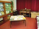 |
Local History Museum of Bērzgale was founded in 1988. There is
the memorial room of writer Antons Rupainis (1906 – 1976), the exposition of municipality history, its famous
people and cultural-historical traditions.
Working hours: Mon– Fri : 9.00 – 12.00,13.00 – 17.00, Sat., Sunday : on request |
|
 |
A family restaurant, located next to the Melluži open-air stage in Jūrmala, 27 km from Riga. European and Latvian cuisine for all of the meals of the day, including soups of the day, salads, main courses, and a selection of desserts. All of this in a wonderfully cosy atmosphere. |
|
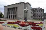 |
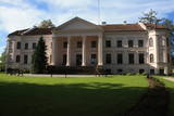
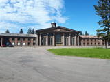
Found at Rīgas Street 22A, this impressive building was suggested by Latvian President Kārlis Ulmanis and built in 1936 and 1937 after a design by the architect Verners Vitands. It is seen as one of the most outstanding architectural monuments from the first period of Latvian independence, and it is said that it was once the most modern multifunctional building in all of Europe. The building now houses the Daugavpils Theatre, the Latgale Central Library, the Latvian Cultural Centre, the Latvian House, the US Information Centre, the Daugavpils Tourism Information Centre and other institutions. Unity Square is alongside the building, and beautiful compositions of flowers are nearby during the growing season. |
|
 |
Dabas takā gar Rojas upi iespējamas 3 dažāda garuma distances, kas lokveidā ved gar upi un tai pieguļošajiem mežiem – 2 km, 7 km un 15 km, kas katra atzīmēta ar savas krāsas norādēm. Dzeltenais aplis 2 km, zilais aplis – 7 km, sarkanais aplis – 15 km. Maršrutus var veikt arī ar velosipēdu, taču braucot ar velo, atsevišķi posmi var būt grūti izbraucami smilšu dēļ. Pie upes ierīkotas vairākas atpūtas vietas ar soliem, galdiem, labierīcībām, šūpolēm, vingrošanas konstrukcijām, atkritumu urnām, kā arī ugunskura un telšu vietām. Pie atpūtas vietām Žocenē un Rojā ir izveidotas arī laivu piestātnes. Takas sākumā upes krastā labiekārtota vieta, kur upē ietek Rojas avots, ko kā ūdensņemšanas vietu iecienījuši vietējie iedzīvotāji. |
|
 |
This territory protects the shore of the onetime Baltic lake of ice, which most significant part stretches for 10 kilometres on the eastern side of the Grobiņa-Ventspils highway from Kapsēde till Vērgale bus stop. From the top of this ancient shoreline there is a lovely view of the Piejūra lowlands, but no specific viewing areas or information stands have been installed. There are protected species and habitats in the territory. |
|
 |
Spilves pļavas tika izmantotas kara aviācijas vajadzībām jau 1. Pasaules kara laikā. 1922. gadā bumbu sabojātā lidlauka atjaunošanu veica Latvijas Republikas Aviācijas divizions Jāzepa Baško vadībā. Drīz pēc tam Spilvē 51 hektāru lielā teritorijā pie Rīgas - Bolderājas dzelzceļa atzara un šosejas iekārtoja arī civilo lidostu, kuru no Rīgas pilsētas nomāja Latvijas Pasta un telegrāfa departaments. |
|
 |
Sēlijā, pie Slates sila, atrodas "Kalnaleiskini". Saimnieks Mārtiņš Uzkurs ir galdnieks, bet sieva Lelde - dizainere abu kopējā galdniecības uzņēmumā un Latvijas Ornitoloģijas biedrības biedre ar pieredzi ekskursiju vadīšanā. |
|


