
| Nr | Name | Beschreibung |
|---|---|---|
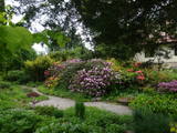 |
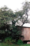
Der Hof und der dendrologische Garten befindet sich unweit von Kuldiga. Im Teich am Haus werden Karpfen und Forellen gezüchtet. Neben dem Gästehaus befindet sich die 1960 angelegte Baumschule „Sauleskalni“. Derzeit finden Sie hier etwa 100 Arten Bäume und Sträucher, darunter 25 heimische Arten und 16 Arten und Sorten Rhododendron. Besondere Stücke sind die älteste Magnolie Lettlands (50 Jahre), ein 45 Jahre alter Perückenstrauch (Cotinus coggygria), ein Ginkgo (Ginkgo biloba), Eleutherococcus sessiliflorus und andere. Als Eintritt ist eine Spende erwünscht. Es gibt einen Raum, der den Gründern des Gartens und deren Geschichte gewidmet ist. Man kann diverse Pflanzen kaufen. |
|
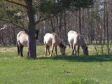 |
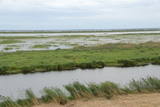
Für den Zweck der Bewirtschaftung der Niederungsauen des Pape-Sees und der Vermehrung der biologischen Vielfalt sind hier Konik-Wildpferde angesiedelt wurden. Die kann man mit einem örtlichen Guide kennenlernen. |
|
 |
Ein Stegpfad, der durch ein Hochmoor führt, in dessen Mitte der Moorsee Teirumnīki eingebettet ist. An dessen Ufer befindet sich ein gut ausgestatteter Rastplatz. Man kann über einen Waldpfad zum Ausgangspunkt zurückkehren. Das Gebiet liegt im Naturschutzgebiet Tīrumnieki.
|
|
 |
Kirkas Hill in Micāni. In 1792, a small castle on the hill Priežukalns (Kirkas kalns) was rebuilt into
Lutheran Church. Nowadays, the hill still is called Kirkas kalns (in German „Kirche” means „church”).
Old people say – under the church there is a big cellar where the jewellery of church and the Mantefel
family is hidden; Manteifel family vault is there too.
|
|
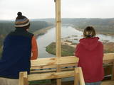 |
The viewing tower was built quite recently. At its foot is a location for relaxation. It offers a good view of one of the curves of the Daugava River – the Adamova curve. A bit beyond is the Curves of Daugava Nature Park. Along the tower is the “Saulkrasti Trail” bicycle route.
|
|
 |
An impressive two-trunk tree at the Nigliņi homestead, this is one of the most impressive trees on the Liv Shore. The Liv language teacher Zoja Sīle was born here. The Medieval Old Cemetery Hill – once used as burial grounds – is nearby. |
|
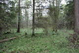 |
One of the rare places (see also Rucavas ivju audze) in Latvia where two rare and protected wild tree species grow - yew-tree and Baltic ivy. Territory is not marked on site with information signs or stands. Territory is not suitable for visitors as visitor without environmental knowledge will see “regular” forest. On the East side of the restricted area is located extending low wall – former narrow gauge railway (600 mm, length 41 km) line Dulbeni – Rucava. Railway was built by German military forces with the goal – to export wood.
|
|
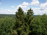 |
The recently renovated viewing tower offers a wonderful view of the impressive and forested ancient Gauja River valley. The Gūdu cliffs are visible. This is part of the Līgatne nature trails territory, where there are wide paddocks of wild animals.
|
|
 |
Dieses Territorium wurde eingerichtet, um den Nesaule – Berg zu schützen, der ein bewaldeter Hügel ist und Nadel- und Feuchtwaldgebiete enthält.
|
|
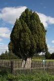 |
This is the thickest common juniper (Juniperus communis) in Latvia and the Baltic States. It stands in the middle of a field and looks wonderful. The tree is sometimes known as the Rieteklis juniper, because the Latvian poet Rieteklis (Jūlijs Eduars Balodis, 1856-1940) like to sit under it.
|
|
 |
This is the thickest Black Alder (Alnus glutinosa) in Latvia
|
|
 |
Der einzige Schlosstorturm in Lettland, wo die Tore mit den Fragmenten des sich hebenden Gitters geblieben sind. Einen Aussischtsplatz ist eingerichtet. Die Ruinen der Burg. |
|
 |
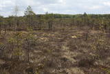
Nature restricted area is established to protect various wetland habitats – Big Kirba Bog and protected plant species within it. Only the West part of the Bog is a protected nature area. The rest of the bog is used mainly for intensive extraction of peat and large cranberry cultivation. Nature restricted area of the bog has no tourism infrastructure therefore is not useable for tourist visits.
|
|
 |
4 km garā un marķētā taka iepazīstina ar dziļo Imulas ieleju – Abavas kreisā krasta pieteku. Īpaši iespaidīga ieleja izskatās bezlapu periodā, kad ir apjaušami tās izmēri un formas. Vēstures cienītāji var upes gultnē uzmeklēt Langsēdes Velna pēdas akmeni. Atrodas dabas parkā „Abavas senleja”. |
|
|
|
Das ist Lettlands größte Flussinsel und befindet sich in der Mitte des Sees Usma. Die Insel ist geschützt, um die alten Kiefernbestände zu bewahren, ebenso verschiedene Pflanzen und Vögel.
|
|
 |
Territory established mainly for protection of bog myrtle and various bird species. An interesting fact is that bog myrtle or sweet gale is used as ingredient for making famous Riga Black Balsam. Brienamais purvs (wade bog) is hard to find and reach therefore it is not suitable for tourism.
|
|
|
|
No 28 m augstā torņa, kas atrodas uz apdzīvotas „salas” – Siksalas Teiču purva vidū, paveras ļoti plaša augstā purva ainava ar Siksalas ezeru, citām minerālzemes salām un Siksalas mazciemu. Tā kā tornis atrodas Teiču dabas rezervātā, to var apmeklēt tikai Dabas aizsardzības pārvaldes inspektora pavadībā, iepriekš piesakot vizīti T: + 371 28333415. |
|
 |
Die Staburags – Klippen von Rauna sind die wichtigsten Klippen, seit die großen Staburags – Klippen der Daugava unter den Wellen des Staudamms während des Baus des Wasserkraftwerkes in der Nähe versanken. Diese Klippen sind etwa 8.000 Jahre alt und werden als Kalkablagerungen aus Moos und anderen Pflanzen gebildet. Die Staburags – Klippen von Rauna werden als der einzige Ort in Lettland benannt, wo das Alpenfettkraut beheimatet ist, jedoch ist es in den letzten 15 Jahren dort nicht mehr gesehen worden. Vielleicht sind die vielen Menschen, die die Klippen jedes Jahr besuchen, schuld daran. Der Strom, der den Kalk zu den Klippen bringt, ist ein Biotop von europäischer Bedeutung.
|
|
 |
Dabas liegums atrodas dienvidaustrumos no Lubāna ezera un tas veidots purva un meža biotopu un tajos esošo sugu aizsardzībai. Gar teritorijas ziemeļu robežu iet Nagļu - Degumnieku ceļš (iekļaujas kopējā Lubāna dambju sistēmā), pa kuru apkārt Lubāna ezeram izveidots velomaršruts. Tas nozīmē, ka teritoriju var aplūkot arī "no malas", netraucējot tās dabiskās norises. Teritorija ietilpst arī Lubāna mitrāja kompleksā.
|
|
 |
The tower is at the edge of the Dundaga-Mazirbe road, at the Šlītere Blue Hills. It offers a lovely view of lowland seashore forests, the local road, and a bit of the ancient shore of the Baltic ice sea.
|
|


