
| No | Name | Description |
|---|---|---|
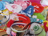 |
The Crafts Chest store offers crafts produced by women in Sabile – knit and crocheted mittens, stockings, hats, shawls, and other useful items that will be wonderful gifts and souvenirs. |
|
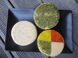 |
The Talsi Dairy was established in 1922 after merging several other dairies. The Talsi Dairy company was established later on these foundations. One of the best known products is “Talsu Ritulis” cheese. Products such as milk, kefir, cottage cheese, butter, cheese, etc., can be purchased at the “Piena sēta” store that is alongside the company. |
|
 |
This restaurant-burger shop specialises in 100% Latvian beef burgers, selected pizzas and natural french fries. |
|
 |
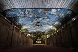
Located in the Mežotne Castle, the saloon offers fine and tasty dishes and beverages. Tours of the ornate castle are available, and the location has one of the loveliest English-style landscape parks in Latvia. Latvian cuisine: Potato pancakes, rolled marinated herring, trout with potatoes in their jackets, blood sausage with lingonberry sauce, grey peas with bacon, stacked rye bread with cranberry jam and whipped cream. Special foods: “Bauska Thaler” – pork in the form of a thaler with a sauce made with Bauska beer. |
|
 |
Zirgi un citi lauku iemītnieki. Dažāda veida izklaides ar zirgiem gan saimniecībā, gan ārpus tās, un saimniecībā mitošo iemītnieku apskate. |
|
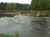 |
This is a territory that is unique at the Latvian and the Baltic level, one which stretches from Valmiera to the Gulbene District. Here we find the irregular Gauja River valley with a dense system of ancient rivers. The meadows on the banks of these rivers are important in terms of biological diversity. There are stands of oak and broad-leaf trees. Many rare and protected birds live and next here – the corn-crake, the woodpecker, etc. The territory is excellent for bird watching, nature studies, ecological tourism and various kinds of active tourism. |
|
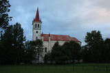 |
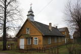
Meklējama Nīcgalē, starp Rīgas – Daugavpils šoseju (A 6) un Daugavas krastu. Baznīcu cēla (neogotikas stils) pēc muižnieka Henriha Plātera - Zīberga iniciatīvas 1862. - 1863. g., veltot to Jaunavas Marijas dzimšanai. Kā jau daudzas citas baznīcas, arī šī ēka un tās interjera priekšmeti cieta 1. pasaules kara laika notikumos. To atjaunoja 1922. gadā. Baznīcas iekārta ir saglabājusies no 19. gs. 60. gadiem, bet, centrālā altāra augšdaļu pārbūvēja 1957. gadā. Dažus gadus vēlāk - 1961. g. uzstādīja ērģeles. |
|
 7 days
|
Our tour leader will meet you at the Riga airport. Depending of the flight time we' ll have an excursion of Riga Old Town and the Central Market listed in UNESCO World Heritage list. Next day we visit potatoes grower near Iecava and successful local multi-sectoral agricultural enterprise at Tervete which combines horse breeding, brewery, crop growing, dairy farm and bio energy production. Also we will visit one of the biggest medical herb growers and producers of the herbal teas. After full day of professional visits, we' ll taste Latvian traditional food and beer in a traditional tavern in Riga. Then we will visit two cattle growers at Sigulda and Cesis area, climb up the tower of Turaida Castle for a great panoramic view and walk charming streets of Cesis Old Town. Afterwards we will visit ecological sheep farm near Valka and stay overnight at the Koni Mill where wool is still processed traditional way, warm blankets and beautiful bed linen made. |
|
 |
Starp cilvēku un zirgu valda īpaša saikne, ne velti zirgs cilvēkam spēj būt gan draugs, gan palīgs, gan sabiedrotais dažādās dzīves situācijās. Saimniecība “Imanti” piedāvā braucienus zirga kamanās ziemā un ratos – vasaras sezonā. |
|
 |
Saimniecība "Dižgāļi" Alsungā nodarbojas ar bioloģisko lauksaimniecību, gaļas liellopu audzēšanu un aitu audzēšanu. Apmeklētājiem ir iespēja aplūkot saimniecību, tajā esošos dzīvniekus, kā arī iegādāties svaigo produkciju. Saimniece pastāstīs par vietas vēsturi, kā arī pacienās viesus ar vistas zupu. |
|
 |
This homestead on the banks of the Rauna River breeds various kinds of fish. During the winter, you can fish for various salmon-type fish, and in the summer you can fish for sturgeon, blue-char, tilapia and trout. You can purchase fish, and tastings are available for groups of visitors. Sillakas is approximately 3 km from Liepasmuiža. |
|
 |
This is one of the oldest open-air museums in Europe, featuring 118 old buildings from all cultural and historical regions of Latvia. You’ll be able to our farms, craftsmen’s and fishermen’s farms (including Liv ones), and a farm once owned by Russian Old Believers in Latgale. Annual celebrations are held, and educational programmes are available. Craftspeople do their work at the museum, and you can quench your thirst at the Priede saloon. |
|
 |
Atrodas Rucavas galvenās ielas malā, netālu no centra.Rucavas draudzi dibināja 1871. gadā, bet izmēros nelielo dievnamu uzcēla 1888. gadā. |
|
 |
Teaching workshops and home cafés are common throughout Estonia, but they are found most in Peipsimaa region. During the workshops, the participants, with the help of the chef, prepare 3-4 dishes, which are then shared afterwards. Emphasis is placed on local products and the favourite recipes of Peipsimaa region. Teaching workshops are mainly organised outdoors, where a fireplace is made; a grill, pot or samovar is used. In winter, workshops even take place on the ice of Lake Peipus. |
|
|
|
The zenith missile brigade and its communications headquarters were used for the provision, planning and co-ordination of radio communications. The object is all but abandoned, but it is owned by the Latvian Repatriation Centre and the Christian Mission.
|
|
 |
The Northern Forts of Liepāja are on the edge of the Baltic Sea, and some parts of them have been washed away. This is a small, but very impressive part of the Liepāja fortifications which once encircled the entire town. The underground bunkers of the forts are on two levels, and it’s worth visiting them in the company of a knowledgeable guide from Karosta (tours are organised from the Karosta prison). There’s a car park alongside the forts. It’s also worth walking down the beach for a distance of around four kilometres to the Northern breakwater. On the shore and in the sea, you’ll see two coastal defence batteries and some pretty impressive views.
|
|
 |
The guesthouse is on the shore of Lake Ciritis with a view of lake islands. Guests are offered Lettigalian dishes, including ones made from lake fish. |
|
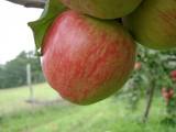 |
This farm is in a lovely location on the western side of the Talsi hillocks, offering a look at Talsi and its area. This is an open farm with grows and processes apples (dried apples, apple chips, apple juice). Visitors are offered an informative tour, with a chance to taste and purchase the products. The farm is in a protected natural area -- the Talsi Hillocks Nature Park. There is an area for tenting during the summer. The owners will teach you to produce a crown from fruit tree branches. The gardens of the farm stretch across the hillocks, and there are several types of local apple trees that are nurtured by the lady of the house. An informative stand alongside the farm features information about the most important values of the nature park. |
|
|
|
Iekārtots bijušā Džūkstes – Lancenieku skolā, kur ikviens var iepazīt mūsu „Pasaku tēva” – Anša Lerha-Puškaita devumu folkloras mantojuma vākšanā.
|
|
 |
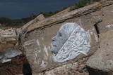
This hill in the Tīreļpurvs swamp is an historical object of national importance – the only area in Latvia that is restricted for cultural and historical purposes. There is unique evidence here of World War I fortifications and the so-called Christmas Battle that was fought here.
|
|


