
| Nr | Nosaukums | Apraksts |
|---|---|---|
 |
Arī sena apdzīvota vieta Nemunas kreisajā krastā. Līdz Liškavai var nokļūt no Druskininku vai Merķines puses, kur pāri Nemunai uzcelti tilti. Liškavā atrodas nozīmīgs vēstures pieminekļu kopums. Pazīstamākie ir Liškavas baznīca un klosteris (Liškiavos bažnyčia, vienuolynas). 1697. g. Liškava tika uzdāvināta Seiņu (Seinų) dominikāņu klosterim. Divus gadus vēlāk te ieradās un uz dzīvi apmetās dominikāņu mūki, kas laikā no 1704. – 1720. g. uzcēla tagad redzamo mūra baznīcu iepriekšējās koka baznīcas vietā. Laikā no 1699. – 1741. tai blakus uzcēla dominikāņu klosteri. Padomju laikā tajā izvietoja gan skolu, gan atpūtas bāzi, gan šūšanas darbnīcas. Mūsdienās ēku komplekss tiek atjaunots, darbojas baznīca (apskatāma no iekšpuses un pazīstama ar septiņiem rokoko stila altāriem) un klosteris. Te piedāvā arī „laicīgus” pakalpojumus - viesu namu, konferenču un semināru zāli, ekskursijas u.c. No klostera pagalma paveras plašs skats uz Nemunas ieleju. Dienvidrietumos no baznīcas atrodas divi ar dziļu Nemunas ielejas sānu gravu nošķirti pauguri – Liškavas svētkalns (Liškavas alkakalnis) un Liškavas pilskalns (Liškiavos piliakalnis), kurus savieno taka. To piekājē atrodas kuģīša piestātne, kas vasaras laikā kursē no Druskininkiem līdz Liškavai. Liškavas pilskalnā ir saglabājušās 14. gs. beigās Vitauta Dižā vadībā celtās un tā arī nepabeigtās pils drupas (torņa fragments). Pils savu stratēģisko nozīmi zaudēja pēc Grīnvaldes kaujas. No pilskalna un svētkalna paveras labs skats uz Nemunas ieleju un Liškavas baznīcu. Senvēstures pētniekiem noteikti ir jāuzmeklē arī kultakmens ar govs pēdu. |
|
 |
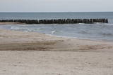
Viens no izteiktākajiem Latvijas piekrastes zemesragiem ar piejūras palieņu pļavām un 1875. g. celto bāku. |
|
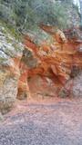 |
Sarkanās klintis savu vārdu ieguvušas pateicoties sarkanajiem iežiem. Tieši sarkanā ir mīlestības krāsa, tāpēc sarkanās klintis ir romatiska pastaigas vieta mīlniekiem. Smilšakmens klintīs redzamas plaisas, kas sašķeļ sarkanīgos iežus, radot neparastu dabas mākslas darbu. To virsma ir diezgan izrobota, kas veido klintīs nelielas alas un nišas. Sarkanajās klintīs ir arī daudz dažādu avotiņu. Pazīstamākais no tiem ir Rūcamavots. Tam ir šāds nosaukums, jo tas, nākot ārā no zemes, izdod nelielu rūkoņu. |
|
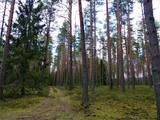 |
Ķekavas novada Daugmales pagastā atrodas pastaigām un dabas baudīšanai piemērots mežs, kurā baudīt dabas daudzveidību. |
|
 |
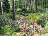
”Cīruļi” atrodas 5 km attālumā no Rūjienas, Jeru pagastā. Īpašums ir pārmantots no paaudzes paaudzē, īpašniekiem vienojoties kopīgā mīlestībā uz ziediem, dažādu augu audzēšanai pārvēršoties arī par vaļasprieku. Dārzā atrodamas arisēmas, ramondas, magnolijas, knifofijas, rodžersijas, ligularijas, rožainā radiola, ehinācijas un vēl daudz vairāk pazīstamu, skaistu augu. Pavasaris iesākas ar sniegarožu un daudzo sīpolpuķu plaukšanu, vēlāk - krāsainie īrisu ziedi un trauslās astilbju skaras. Daudz skaistuma un krāsainības puķu dobēm piedod heihēras un hostas, kas priecē līdz pat vēlam rudenim. Dārzā aug arī skujeņi, vīteņaugi un katru gadu ražojoši vīnogulāji, kas veido pašu dārza telpu.
|
|
 |
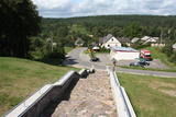
Līdz mūsdienām gandrīz pilnībā ir saglabājies muižas apbūves komplekss (> 12 ēkas) un parks. Muižas pils celta 19. gs. 40. gados uz palielas ovālas salas, ko no visām pusēm ieslēdz grāvis. Šāds kungu mājas izvietojums imitēja viduslaiku nocietināto piļu paraugu. Kungu mājā šobrīd atrodas pagasta pārvalde, bibliotēka un pasts. Interesenti var doties izzinošā ekskursijā pa muižu un tās tuvējo apkārtni. Ar Veselavas muižu saistīti nostāsti par baronu un skaisto meitu – Kausuļu Rasu, kas līdzīgi Turaidas Rozei nepakļāvusies muižkunga iegribām. Lai dzirdētu šo stāstu pilnībā, ir jādodas uz Veselavu. |
|
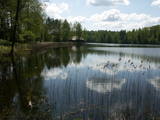 |
Salājs ir līčiem un salām bagāts ezers. Tam blakus esošajā Mazā Soloja krastā ir meklējams Milkas pilskalns un izveidota atpūtas bāze. Abu ezeru apkārtne ir ļoti ainaviska, tādēļ tā iekļauta dabas lieguma zonā. |
|
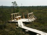 |
Planču purva laipas galā ir izveidots skatu laukums un atpūtas vieta, no kuras var baudīt augstā tipa purva ainavas un ieelpot savdabīgo purva gaisu. Vienīgais Latvijas brīvdabas infrastruktūras objekts, kur informācija ir veidota arī Braila rakstā. Atrodas ZBR.
|
|
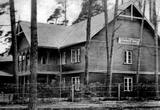 |
„Strand” komplekss bija lielākais un greznākais Neibādē. Tas sastāvēja no trim ēkām, deju paviljona un parka. Mūsdienās saglabājusies tikai viesnīcas ēka, kurā bija iekārtota Saulkrastu ambulance – Ainažu ielā Nr. 17. (Avots: Saulkrastu TIC) |
|
 |
Restorāna a’ la carte ēdienkartē likts uzsvars uz kvalitatīvu medījumu gaļu. Zivju mīļotājiem tiks piedāvātas Sangaste Loss dīķī tikko ķertas Sibīrijas stores, tādējādi nodrošinot, ka izejvielas vienmēr ir svaigas. Godā tiek turēti senie ēdienu gatavošanas paņēmieni, piemēram, cepšana uz ugunskura dabīgos dūmos. |
|
 3 dienas
|
Trīs dienu ilgais maršruts ļaus iepazīt ne tikai vienu no ainaviski neparastākajiem Baltijas dabas veidojumiem - Kuršu kāpām, bet arī dažām interesantām teritorijām tepat Latvijā - Papes dabas parku un Liepājas Karaostsu. Pēdējo vērts apskatīt, kamēr tā vēl nav zaudējusi savu "padomju šarmu". Ne mazums jaunu un nepiedzīvotu iespaidu radīsies arī apmeklējot divas savdabīgas cilvēku darinātus veidojumus - "Akmeņu pilsētu" un "Absurda pilsētu”, kurām nav līdzīgu veidojumu ne tikai Baltijas, bet arī daudz plašākā mērogā. |
|
|
|
Ristnas bāka atrodas uz Ristnas ziemeļu puses zemesraga. 1873. gadā pasūtītā bāka izgatavota Francijā 1874. gadā. Tās pakājē atrodas neliela ēdnīca. |
|
 |
Ainaviskais Pakrujo muižas parks, kura struktūra palikusi līdz mūsdienām, ticis iekopts 1850. – 1860. gadā. No vienas puses dabisku teritorijas robežu izveido aizsprostotās Kruojas upes josla, no otras puses teritoriju aptver laukakmeņu žogs. Pēc to laiku angļu parku formēšanas shēmas priekšroka tika dabiskai ainavai un dabīguma imitācijai. Parkā aug aptuveni 26 nosaukumu koki, starp kuriem – vēl pirms pāris simtu gadiem atvestie un iestādītie retie augi no pasaules dažādām malām. |
|
 |
"Irbes šaurums” – īpaši nozīmīga teritorija putnu migrācijas laikā - biežāk sastopamās aizsargājamās putnu sugas – tumšā pīle, melnā pīle, kākaulis, mazais ķīris, brūnkakla un melnkakla gārgales, kā arī melnais alks. Teritorija atrodas iepretim Dundagas novadam un Ventspils novadam, tās platība ir 172 412 ha.
|
|
 |
Ungurmuižas parkā, kas ir slavens ar izcilajiem un resnajiem dižozoliem, kuru aprupējošie stumbri, dzīvā un mirusī koksne ir daudzu sugu, t.sk. jau Eiropā izzudušu vienīgā mājvieta, ir izveidota dižkoku taka. Garums 1,3 km, laiks līdz 1 h. Parkā atrodas Latvijā vienīgā līdz mūsdienām saglabājusies 18. gs. sākuma koka pils u.c. kulūrvēsturiskas vērtības
|
|
 5 dienas
|
Izbraucot no Rīgas, maršruts ved cauri vēsturiskajam Jūrmalas kūrortam līdz Pūres Šokolādes muzejam, kur ir iespējams ne vien redzēt Pūres šokolādes produkciju, bet arī to nogaršot. Tālāk dodieties uz Sabili un tur esošo Vīna kalnu. Apmeklējiet vietējo vīna darītavu, kurā izrādīs vīnogu dārzu un pastāstīs par vīnogu audzēšanu Latvijas klimatiskajos apstākļos mūsdienās, kā arī - dzērienu degustācija. Pēc tam dodieties uz apburošo Kuldīgu, kur arī ir iespējams degustēt vīnus. Nākamajā dienā dodieties uz eko vīnu degustāciju Aizputē un Durbē, un pēc tam dodieties uz Liepāju, kur iespējams izbaudīt smilšaino jūras pludmali, māksliniecisko atmosfēru un nozīmīgo militāro mantojumu Karostā. Tālāk maršruts ved gar jūras piekrasti līdz Pāvilostai, kur jūs variet doties izbraucienā ar tradicionālu zvejnieku laivu. Alsungā - Suitu sievas un tradicionālā latviešu virtuve. Pēc tam dodieties pastaigā gar Jūrkalnes stāvkrastiem, un tālāk - uz Ventspili. Nākamajā dienā apmeklējiet vietējo zvejnieku, lai redzētu zivju kūpināšanas procesu. Pastaiga gar Kolkas ragu, kur atklātā jūra satiekas ar Rīgas jūras līci. Dodoties atpakaļ uz Rīgu, apmeklējiet vīndari Talsos. |
|
 |
Rucavas arborētums sastāv no trīs ģeogrāfiski dažādi novietotām vietām Rucavā un tās apkaimē. Pirmā daļa ir pašas Rucavas centra apstādījumi iepretim Rucavas novada domei, kuros aug magnolijas, deicijas, katalpas, baltegļu stādījumi u.c. Otra daļa atrodas pie Rucavas pamatskolas, kur mežā ir izveidota rodedendru, īvju un paciprešu kolekcija. Savukārt, trešā daļa atrodas nepilnus 4 km austrumos no Rucavas – bij. Rucavas muižas vietā (tikai pamati), ko sauc par Muižas kalna stādījumiem. Šī ir viena no ainaviskākajām arborētuma daļām, no kuras paveras neparasti plašs un skaists skats uz Sventājas dabas liegumu, kas ir īpaši aizsargājama dabas teritorija. Šeit 1996. g. arī aizsākās arborētuma veidošana, kas notika Salaspils botāniskā dārza dendralogu Raimonda Cinovska un Ināras Bondares vadībā. Kādēļ par arborētuma vietu izvēlēta Rucava? Tādēļ, ka dienvidkurzemes piejūrā ir maigāks klimats, nekā citur iekšzemē, tādēļ šeit mēs varam apskatīt augam daudzas siltāku zemju eksotisko koku un krūmu sugas. Maijā, kad zied rododendri, Rucavas arborētumā notiek „Dārza svētki”. Arborētuma daļas var apskatīt savā gaitā, bet, ja gida pavadībā, nepieciešama iepriekšēja pieteikšanās. |
|
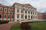 |
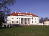
Atrodas uz Pilssalas starp Lielupi un Driksu. 1738. g. Livonijas ordeņa pils vietā uzsāka jaunas pils celtniecību, kas noritēja laika posmā no 1738. - 1740. g. un 1762. - 1772. gada. Barokālā stilā būvēto pili projektēja itāļu arhitekts Frančesko Bartolomeo Rastrelli (viņa agrīnā radošā perioda nozīmīgākais darbs). Celtne ir piedzīvojusi ugunsgrēku, postīta un pārbūvēta. 1937. g. tiek uzcelts (E. Laubes projekts) pils rietumu spārns, kā rezultātā tā iegūst noslēgta četrstūra formu. Mūsdienās pilī atrodas Latvijas Lauksaimniecības universitāte. 1968. g. te izveidoja muzeju. Pils DA spārna cokolstāvā apskatāmas Kurzemes un Zemgales valdnieku - Ketleru un Bīronu dzimtas kapenes (laika posms no 1569. – 1791. g.) ar 18 restaurētiem sarkofāgiem. |
|
 |
Kafejnīca "Kalnakrogs" atrodas Skrundas novada Rudbāržu pagastā pie Rīgas - Liepājas šosejas. Kafejnīcas ēdienkartē iekļauti latviskie ēdieni, iespējams pasūtīt banketu un izīrēt telpas semināriem. Piedāvā nakšņošanu. |
|
 |
"Pūres beķereja" atrodas pilsētas galvenās gājēju ielas malā. Cep speķa pīrādziņus, biezpienmaizītes, kanēļmaizītes, kliņģerus un tortes. Piedāvā vintage stila velosipēdu nomu. |
|


