
| No | Name | Description |
|---|---|---|
 5 days
|
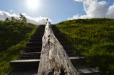
This route involves unique views that have never been seen before in Latvia! The impressively steep shoreline of the Baltic Sea begins a few kilometres to the North of Pāvilosta and ends shortly before Ošvalki, stretching for nearly 20 kilometres in all. Its most impressive and unusual forms are seen between Strante and Ulmale. The entire route leads down the western boundary of the former Iron Curtain, because the Baltic Sea coastline was militarised during the Soviet era and unavailable to most people. Remnants of former military objects and old tank routes in the dunes can still be seen. The largest biotopes of grey dunes stretch for several kilometres around Ventspils and Užava. These are unusual landscapes that can seldom be seen elsewhere in Europe. You can walk more than 10 kilometres here and not see another soul. Route information from Latvijas Lauku forums |
|
 |
The garden is located on the very bank of the River Gauja, near the Valmiera Castle ruins. A story about the use of plants in preparing meals. Bread, gingerbread baking, cheese making programmes. |
|
 |
The farmstead Riveni specializes in fruitgrowing and the products of reprocessing those – dried apples, apple juice. |
|
 |
One of the biggest castle hills in Estonia, which is surrounded by walls built of stone. It is mentioned in Livonian Chronicle of Henry as one of the best fortifications at that time. |
|
 |
This guesthouse is on Rusen Island near the shore of the Pakalne River. The owners collect plants, process them in accordance with folk recipes, and then offer various teas, infusions and other beverages that have medicinal properties to improve people's moods and their tonus. |
|
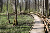 |
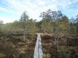
The excessively damp forests at this place include the Vēršupīte River bog, and this is one of the most diverse biotopes in Latvia in terms of the number of species that can be found here. The fact that the area is regularly flooded is shown by the fat roots of black alders – indeed, the place looks like a stand of mangroves. The wooden pathway that is the Dumbrāju trail starts at the Forest House for those who wish to examine the bog. The most impressive views are seen during spring floods or rainy seasons at other times of the year. The little river breaks out of its bed and floods a large territory. The Lake Sloka hiking trail is another place where you can study the Vēršupīte bog. The circular trail is 3 km long, and its beginning is at the Lake Sloka bird watching tower. |
|
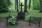 |
To the North of the Cesvaine Castle is a park that is crossed by the rapidly flowing Sūla River. The Cesvaine castle hill is on the northern bank of the river, is around 15 m high and is covered by trees today. The grave of the owner of the castle, Adolf von Wolff, is there. It is said that he wanted to have his casket dragged to the gravesite on a sled. He died during the summer, but that was done anyway. The park features a wide diversity of trees and bushes, some of which the owner brought home from his extensive travels. |
|
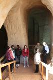 |
The area of the ancient Piusa River valley that is between the villages of Vana-Vastseliina and Ignasõ is around 15 km long, features some substantial rapids, and offers a view of beautiful Devonian period cliffs. The largest, Härma müür, is 43 metres high and is the highest sandstone cliff in Estonia. There are caves from old mines in the village of Piusa. A small part of the mines, which have tunnels that are more than 10 km long in all, has been tured into a local museum.
|
|
 |
The Kelme Estate is one of the last remaining provincial estates in Lithuania. Designed in the Baroque style, it is a large and closed estate farm with many authentic buildings, gardens and bodies of water. The geometric park is a vivid example of Baroque style, and it is divided up into various parts by alleys. There is a viewing mound in the park. Most of the trees are ancient, indeed, but the best part of the estate is behind it -- one large and three smaller ponds, as well as a viewing mount that is in the ancient park. |
|
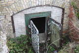 |
The so-called Comet Fort was built on the Left Bank of the Daugava at its mouth, not far from the present Daugavgrīva lighthouse. It was built around the same time as the other forts of Mangaļsala (around 1808, although some sources say 1788). There were four Kane-type 152-mm cannons. The defensive batteries at Komētforts and Mangaļsala repelled a British naval attack in the Daugava estuary in 1855. It has to be added that Komētforts is a cultural monument of local importance. If we go along the shore of the sea from the Daugavgrīva nature reserve toward the Daugavgrīva lighthouse and scale the frontal dunes (without going past the sign which says “Closed Territory. Border Zone.”), then we can see the positions of the cannons, as well as underground cellars where munitions were once stored. The territory starts approximately 500 metres before the Daugavgrīva lighthouse and stretches to the lighthouse itself. During Soviet times, the territory was closed to civilians, because many secret military objects were in this area and in Bolderāja.
|
|
 |
Muiža vēsturiskajos avotos ir minēta jau 1560. gadā. Tagad redzamā kungu māja ir celta no akmens 1805. g. Padomju laikos tajā atradās Matsalu rezervāta administrācija, bet mūsdienās ēkā ir izveidota viesnīca. Līdz muižai nokļūstam pa skaistu aleju, kuras apkaimē ir redzamas citas muižas kompleksa ēkas. |
|
 |
Atrodas ļoti skaistā vietā – Krimuldas muižas kompleksa teritorijā, vienā no muižas vēsturiskajām ēkām. Mājīgs interjers, mākslinieka J. Annmaņa apgleznotas sienas. Piedāvā turpat muižā darinātos mājas vīnus un „Muižas stipro”. Garšīgas tējas, uzkodas un siltie ēdieni. |
|
 |
Piedāvā ļoti gardus Lietuviešu tradicionālos ēdienus. Var pieņemt līdz 300 personām. Ir āra terase un dzīvā mūzika. Pieņem bankas kartes, pieejama autostāvvieta. |
|
 |
This village is at the place where the Irbe (Dižirve, Īra) River flows into the sea, and it is on both shores of the river (sea side and land side). The name of Irbe was recorded for the first time in a 1310 border agreement between the bishop of Kurzeme and the Rīga Dome Capitol. The name of Lielirbe (Irvemūnde) was recorded for the first time in a document from an arbitration court in 1387. At the end of the 19th century, the small port at Lielirbe was an active centre for the sale and transport of timber materials. In the late 19th and early 20th centuries, the largest number of sailing ships among villages on the western shore of Kurzeme was built there. In 1939, the village had some 300 residents, more than 70 houses and a Baptist church which is now at the Ventspils Open Air Museum. A narrow-gauge railroad passed through the village, which had a post and telegraph office, two grocery stores, an elementary school, a choir and a brass band. Lielirbe was one of the largest villages to disappear after World War II. Cultural historian Valda Marija Šuvcāne (1923-2007) was born in Lielirbe, and her daughter, Baiba Šuvcāne, is continuing her mother's work by writing important papers about life along the Livonian coastline. By 2019, a bridge is to be reinstalled across the Irbe River. |
|
|
|
Gebaut als ein Gebäude des Festungstyps. Wurde in der Zeit des Livländischen Kriegs und des Nordkriegs zerstört. 1865 wurde der heutige Turm gebaut. Die von J. V. Rabe gebaute Kanzel mit Spindeltreppe. |
|
 |
Here you can cross a swamp without getting your feet wet and enjoy the local environment, which has been little touched by humankind. You can take the dam of the former Smiltene-Valmiera-Ainaži narrow gauge railroad. It crosses the swamp from the South-East to the North-West and is three to four km in length. There is also a circular wooden pathway on the eastern side of the dam. The length of the trail (including the dam) is around 5km, and it will take 90 minutes to two hours to traverse. The area is covered by environmental restrictions.
|
|
 |
The farm produces six different kinds of blackberries. You can tour the surrounding fields, learn about how blackberries are grown, and taste and purchase valuable berries. Your children will love the rabbits and goats that are at the farm. |
|
 |
Bejas meža dabas liegums veidots no reljefa viedokļa - interesantā, pauguru un starppauguru ieplaku saposmotā teritorijā, kuru klāj vecs un varens egļu mežs. Bejas mežā atrodas viena no Alūksnes rajonā vairākām "Velna pēdēm" - dziļa, krāterveida ieplaka, ko veidojis kūstošais ledājs.
|
|
 |
The holiday houses are located near Lake Ieva, 30 m from the lake shore. On the 1st floor of the holiday house - lounge with fireplace and glazed veranda, sauna (50.00 EUR / evening), small kitchenette, toilet. Outside-small terrace overlooking the lake. On the 2nd floor there are 2 isolated rooms and 10 beds. By the lake - a fireplace, a well-groomed swimming area with a footbridge. Boats and catamarans can be rented. |
|
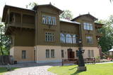 |
On the banks of the Venta River is a treasure of wooden architecture – the so-called Bangerts Villa, which relates to romantic stories and legends and was recently restored. It is said that a man known as Captain Bangerts bought the villa as a gift to present to his Parisian bride. The Kuldīga Administrative District Museum has been in the building since 1940. Since reconstruction, unique wall paintings and other interior design details have been restored, and the flat of the Bangerts family allows people to see how wealthy residents of the city lived in the early 20th century. Also on display are some of the sets of playing cards that have been collected by Jānis Mētra. |
|


