
| No | Name | Description |
|---|---|---|
 |
Atrodas Lielvārdes parkā pie Rumbiņas ietekas Daugavā. Līdzīgi kā citur, arī šeit 13. gs. pirmajā pusē bīskapa pili cēla nodedzinātās lībiešu koka pils vietā. Mūra pili nopostīja Livonijas kara laikā - 1577. g. Tikai 1987. g. notika drupu konservācija. Lielvārdes parka veidošanu uzsāka 19. gs. beigās Lielvārdes muižas barona Artura fon Vulfa vadībā. Sagaidot eposa „Lāčplēsis” simtgadi tajā izvietoja sešpadsmit no ozolkoka veidotas skulptūras (t.s. Skulptūru dārzs) (autori V. Ansavs, P. Mellis, Ē. Delpers, A. Dauvarte). Aiz pilsdrupām Daugavas krastā ir stāva krauja ar dolomīta iežuatsegumu. Līdz HES ūdenskrātuvei var nokļūt pa kāpnēm. Lielvārdes muižas pils līdz mūsdienām nav saglabājusies. |
|
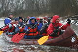 |
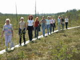
The company runs wildlife tours: kayak trips at sea in summer, bogshoeing in bogs in autumn, snowshoeing trips in winter and canoeing on rivers in spring. |
|
 |
In a document from 1387, the village is named Minor Irva. Until the mid-20th century, Mazirbe was the largest Livonian village on the coast of Kurzeme. It was a fishing village and a centre for fishing. The village had a church, school, pharmacy, forestry company, several stores, a post and telegraph office, train station, barber shop, bakery and photo workshop, as well as a brick kiln. During the 1930s, a local fishing co-operative built a fish processing plant here. The Livonian Association was established here in 1923, and the Livonian People's Centre was opened in 1939. Oppoite the centre is the Stūrīši homestead (the home of the Taizel dynasty), where you can learn about everyday household objects and, by ordering it advance, taste local foods. The first chairmen of the Livonian Association, Kārlis Stalte and Māritņš Lepste, lived in Mazirbe. Cultural worker Kārlis Stalte (1870-1978) spent man years as the verger and organist of a church in Mazirbe. Mārtiņš Lepste was a Livonian language teacher in the 1930s. The former Maritime School building can be viewed from the outside. Some 2,000 students attended the school between 1894 and 1914. During Soviet years, the army had a base here. |
|
|
|
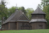
Puderova Old-Believers Prayer House. The architectural monument of local importance was built in
the beginning of the 20th century.
|
|
 7 days
|
The tour from Riga to Tallinn combines natural and cultural heritage and includes lovely landscapes and 15 nature trails which cross marshlands, meadows and forests along the shores of the Baltic Sea, including several protected nature reserves. Many trails are equipped with viewing towers for birdwatching. Randu meadows near Ainazi contains one third of Latvia's entire plant species. A boardwalk leads through reeds to a viewing platform with views over the meadow and the sea. Saaremaa island is interesting with very different natural attractions to the mainland - dolomite cliffs, juniper heaths, a meteorite lake and rocky sea shore. The tour passes rural farms and traditional villages typical of the coastal areas. Hiiumaa island is a laid back place and retains a very Estonian atmosphere with an important bird reserve at Kaina Bay, unusual Saare Tirp as well as several small islets off its south-eastern coast. Back on the mainland, Paldiski peninsula gives a glimpse of the recent history with its former Soviet military base. |
|
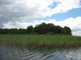 |
Of the many islands in Lake Rušons, ten are restricted natural areas so as to protect the broadleaf forests which are on the islands and the endangered plants found therein. An ancient cult location – the Rušons Sacrificial Rock – is found on Upursala island.
|
|
 |
This garden has several times been declared to be Latvia's most outstanding exemplary decorative garden. The owners offer tours and advice on gardening. |
|
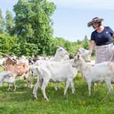 |
A Latvian traditional farm with a herd of some 150 goats, offering tours of the farm and cheese for sale. They offer also home-made ice-cream from the goat milk and a soup made on open-fire. Also latvian traditional sauna is available. The products can also be bought at the little market in Straupe. |
|
 |
The Jumari farm is located in Dundaga parish, near Valpene. The 7th generation of the owners’ family run the farm. The farm produces fruit, berries and vegetables. Beautiful flowers and shrubs surround the house. Visitors can tour the farm, learn about growing blackberries and biological farming methods, and enjoy herbal teas. The lady of the house offers small pillows stuffed with grasses, as well as woven bookmarks. She also bakes sklandrauši, the traditional carrot buns. Jumari is one of the destinations along Dundaga Administrative District bicycling routes. |
|
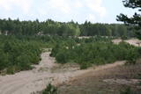 |
There are several large territories on either side of the Irbe River that were linked at one time by tank roads. Tank training and inspections were conducted here at one time, but now the territory has been abandoned and is slowly being reclaimed by the forest.
|
|
 |
Die Kirche hat einen 1800 gebauten einzigartigen achteckigen Glockenturm. Blick auf den Lūšiai-See. |
|
 |
Saimniecība audzē dažādus dārzeņus, lapu salātus, gurķus, dilles, ķiplokus, brokoļus, ziedkāpostus, sīpolus, ķirbjus, bietes utml. Vasarā un rudenī pieejamas avenes. Pārdošanā svaigi dārzeņi un augļi. |
|
 |
This is a highland swamp with several little lakes. At the SE of the area is a wooden trail.
|
|
 |
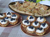
Lapsu Mājas sieri tiek gatavoti Ogrē. Godinot latviskās tradīcijas, tos 2013. gadā kā mazais mājražotājs sāka siet Jānis Lapsa savā mājas virtuvē. Lapsu Mājas sieru gatavošanas process ir 101% roku darbs - sākot no sieru masas gatavošanas līdz pat iepakošanai. SieriMājas siers ar samazinātu sāls daudzumu no govs piena (pieejami ar 27 dažādām garšām). Šiem sieriem ir piešķirta kvalitātes zīme "Zaļā karotīte". Bezlaktozes mājas siers ar samazinātu sāls daudzumu no bezlaktozes govs piena. 2021. gadā kā pirmie Latvijā sāka ražot bezlaktozes mājas sierus no govs piena. Jāņu siers ar sviestu vai ar saldo krējumu. Kā top siersTā kā siers tiek ražots pilsētas teritorijā, piena produkcija tiek iepirkta. Sieriem ar samazinātu sāls daudzumu un Jāņu sieram produkcija tiek iepirkta no piena pārstrādes uzņēmuma “Straupe”. Bezlaktozes sieriem produkcija tiek iepirkta no AS “Jaunpils pienotava”. Savukārt olas tiek iegādātas no Ropažu zemnieku saimniecības “Rasas”. Apmeklētājiem
Kur iegādāties sierus
|
|
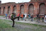 |
An impressive set of military structures between the Baltic Sea and Lake Liepāja and Lake Tosmare. Construction of the fortress began in the late 19th century on the basis of a decree by Russian Tsar Alexander III, and it cost 45 million gold roubles. The fortress includes accommodations and elements of fortifications – sites for cannons, trenches, gunpowder cellars, systems of canals, a narrow-gauge rail line, etc. In 1908, the fortress was shut down because of a change in Russia’s defence concept, and the construction of it was declared to have been a strategic mistake. There were attempts to blow up the underground structures and cellars during World War I, but that did not really succeed. Some elements of the fortress were of great importance in Latvia’s liberation battles. Surviving today are the Northern forts, the Central fort, the Eastern fort, the Southern fort, the shoreline defensive batteries (No. 23, 3), Redāns, Lunete, and others. Most are not improved, so visits may be dangerous. The northern part of the fortress includes the Military Port, which has experienced seven different armies and regimes. During the Soviet years, it was closed to civilians. There are many outstanding monuments to military history. Tourists love the Karosta prison, which offers educational programmes. |
|
|
|
This is a site where you can try out ancient weapons – bows and crossbows (a reproduction of items from the 14th and 15th century), throwing an axe (replicas of German axes from the 13th century), and spears. Once you’ve learned how to handle those weapons, you can also forge a copy of a Medieval coin. You can try on copies of armoured caps and gloves and have your picture taken with a sword or battle axe. For larger groups, the enterprise will organise ancient sports and table games.
|
|
 |
Vēstures avotos pirmoreiz minēta 1483. g. Pilsētas uzplaukums bija vērojams pēc dzelzceļa uzbūvēšanas 19. gs. beigās, kad barons Korfs sadalīja un iznomāja apbūvei muižas zemi. Pilsētas tiesības Priekule ieguva 1928. g. Pilsēta smagi cieta 2. pasaules kara pēdējos mēnešos, - t.s. Kurzemes katla laikā, kuru laikā tika sagrautas 410 no 450 ēkām. Mūsdienās tā ir neliela pilsētiņa ar mazstāvu apbūvi un nesteidzīgu dzīves ritmu. |
|
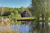 |
This pile of big rocks stands around 9 m high and is some kind of monument to Krišjānis Barons and his achievements on behalf of the Latvian people. His parents lived at the Valpene Estate, and the rocks contain engraved names of lost homesteads from the region. Their direction in the pyramid indicates where the homesteads used to be. The idea for the rocks came from Imants Ziedonis, and the pyramid was built by the sculptor Vilnis Titāns. |
|
 |
The café Bastions is located in the historic centre of Valmiera on former medieval fortifications. Their menu offers Latvian cuisine and an extensive variety of breakfast, lunch and dinner meals. The café collaborates with local farmers and producers. During summer, enjoy your meal on the beautiful outside terrace overlooking Lake Dzirnavu. |
|
 |
The farm shows traditional rural life activities, raising sheep and Estonian Blackhead sheep. A heritage trail on the farm takes in a sacred grove, ancient burial sites and fields, and we tell stories of ancient Estonians and history of the farm. Handicrafts are displayed and wool workshops are offered. |
|


