
| No | Name | Description |
|---|---|---|
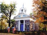 |
Kulnevskaya (Ilzeskalns) Orthodox Church was built in 1832 by Kulnevs, the landlord of Ilzenberg
(Ilzeskalns) manor house. He was also the brother of Jacob Kulnevs. The Church has an iconostasis with
icons of the 19th century. The rectangular building has semicircular niches at its sides. The members of Kulnevs
family are buried here. The place of tomb is a rare phenomenon in Orthodox churches of Latvia.
|
|
 2 days
|
Here you will learn about home-based manufacturers, farms, companies and others in southern Vidzeme that produce various dairy products such as milk, yogurt, cottage cheese, cheese, ice cream, etc. From Rīga, take the Vidzeme Highway and turn toward Mālpils. On the way to Ērgļi and Jumurda, you’ll be delighted by the hillocks of the Vidzeme highlands and the lovely landscape that they represent. Near Ērgļi you will find Braki, the home of the classical Latvian author Rūdolfs Blaumanis, Meņģeļi, home of the Jurjāns brothers, and the Jumurda Estate. Drive on through Cesvaine, stopping to look at its impressive castle, and on to Madona, where you can have a delicious meal. From Madona, follow the lovely banks of the Daugava River to Koknese (Destiny Island, the Koknese castle, park and church), and on to Skrīveri, where the author Andrejs Upītis was born. There’s a homemade ice cream place and the factory that produces the universally known penuche candy that is sold under the “Gotiņa” brand name in Latvia. Then drive to Ogre for some Sierštelle cheeses and then back to Rīga. |
|
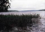 |
Ap 9,5 km garais un līdz kilometru platais ezers atrodas subglaciālā – t.i. ledāja veidotā vagā, tādēļ tas ir ne tikai Lietuvas, bet arī otrs Baltijas dziļākais ezers (pēc dažādiem avotiem 60,5 m vai 62,5 m). Tauragna dienvidu krastā paceļas Taurapils pilskalns (Taurapilio piliakalnis). Saglabājušies nostāsti gan par pagānu priesteri, kas te dzīvojis, gan nogrimušu baznīcu, gan laikiem, kad pilskalnu no visām pusēm apņēmis ūdens. No pilskalna plakuma paveras visaptverošs skats uz Tauragnu. |
|
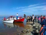 |
The company provides wildlife tours – seal watching, walking, cycling or skiing trips, rubber boat trips to Vilsandi and other islands, orchid trips, and trips to learn about culture and life of the manors, towns and villages, crafts and seafaring. Miku forest park in Vilsandi National Park is where visitors can learn about and try various forestry jobs. |
|
|
|
Atrodas Zebrus ezera austrumu krastā pie Latvijas Valsts mežu laivu bāzes. No torņa labi pārskatāms Zebrus ezers, ziemeļu virzienā – Ezerlūķu pilskalns. Laivu bāzē – atpūtas vietas. |
|
 |
The farm breeds several species of chinchillas and offers a look at them. There are also decorative pheasants, peacocks, doves and different kinds of chickens, along with marmots, dwarf goats, chipmunks, rabbits, a pony, etc. You can purchase chinchillas, decorative birds and other animals, along with quail eggs, chinchilla pelts and souvenirs. There are also ponds for fishing. |
|
 |
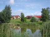
The Kaigari farm is in the Mežotne Parish of the Bauska Administrative District and specialises in grain farming. The farm makes active use of EU funding, some of which has been used to buy modern agricultural equipment. The farm has some 400 ha of land, and the apple orchard offers a very beautiful landscape, including the Lielupe River valley. |
|
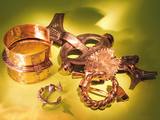 |
The Museum of Malta Secondary School No 2. Exhibition of the
ancient Latgalian jewellery of the 6th –13th century.
Working hours: Mon– Fri : 9.00 – 16.00, Sat., Sunday : closed |
|
 |
A family-friendly grill bar and restaurant with a children’s play area, special dishes for children, and a positive and relaxed atmosphere. The chef mainly opts for Latvian products when creating the menu. |
|
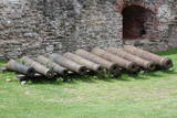 |
The Bauska Castle contains a collection of cast iron cannons which date back to the latter half of the 17th century and the beginning of the 18th century. They were manufactured in the Duchy of Courland. The cannons that are in the garden of the castle were not found there – they were found in different locations in Zemgale. Four of the largest cannons came from Jaunsvirlauka, where they were found on the banks of the Lielupe River opposite Emburga. They are the best preserved weapons of their type in Latvia. The only cannon that was found in the castle itself is currently in its South-eastern tower as a thematic exhibit. When it was being cleaned, two cannonballs were found in the weapons. The local Livonian Order castle is in ruins, but it and its defensive structures, including earthen ramparts that were installed from the mid-15th until the early 18th century, represent an important element of Latvia’s military heritage.
|
|
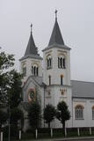 |
The church was built in the Neoromantic style between 1936 and 1939 on the basis of a design by the architect Pavlov. It was consecrated before the completion of construction, this happening in 1937. The church honours the Anguished Mother of God, and the central altar is dedicated to her. Icons in the building date back to the early 20th century, and a statue of the Fatima Mother of God is in the yard near the entrance. |
|
 |
This is a farm which produces beef. You can take a tour, during which you can learn about, taste and purchase untraditional herbs and exotic tea plants. |
|
 |
Dabas liegums veidots ezera, tā salu, ainavas, augu, putnu un sikspārņu aizsardzībai. Liegumu var apskatīt "no malas" - no ceļa, kas iet gar tā ziemeļu un ziemeļaustrumu robežu.
|
|
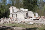 |
The communications facility in the forests of Bārta has been abandoned and is not being used other than for dismantling of buildings to obtain building materials.
|
|
 |
The restaurant is in the Grand Hall of the restored Liepupe Estate. Ancient cooking traditions are merged with modern culinary methods. The restaurant works with local farmers and grows greens and herbs in its own garden. Guests are welcome to help with preparing foods on a wood-fired stove in the antique kitchen. Latvian cuisine: Rye bread canapé, a plate of Latvian cheeses, country salad with greens, grilled seasonal vegetables, estate stock, local fish dishes, baked port chop, baked herb-crusted mutton. |
|
 |
Very expressive form of relief with wide look over the neighborhood. On its peak there's ruins of the castle of bishop Hermanis which was built in 1224. The world's oldest firearm was found here. |
|
 |
The "Jumis" café is on the side of the Rīga-Liepāja highway (A9). The interior is finished in wood. Latvian cuisine: Cottage cheese with herring and soured cream, farmer’s breakfast, mushroom soup, pork cooked in onions, sautéed liver, homemade steak haché, grilled pork ribs, potato pancakes, stuffed pancakes. Special foods: The “Jumis” pot of ham. |
|
|
|
Pie Melekiem sākas dabas lieguma teritorija. Meleku
krastmala būtiski mainījās 2005. g. orkāna laikā.
|
|
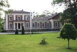 |
Atrodas Taurenē, Gaujas labajā krastā. Muižas apbūve, kurā ietilpst pils (19. gs. 80. gadi, arhitekts – R. G. Šmēlings, historisma un neoklasicisma stils), senie alus pagrabi, klēts, vecā pils un parks, veidojies 19. - 20. gs. Šobrīd muižas pilī atrodas Taurenes pagasta pārvalde un kultūras nams. Muižas kompleksā ietilpst ēka, kurā atrodas Vecpiebalgas novada tūrisma informācijas punkts un Taurenes novadpētniecības ekspozīcija (senajā ledus pagrabā). Parkā (ziemeļos no pils) uzmeklējams piemiņas akmens, kas veltīts komunistiskā terora upuriem. Pie Nēķena muižas sākās 0,4 km garā Cieres dabas taka, kas iepazīstina ar Gaujas krastu mitrājiem. |
|
 |
The Miervaldis Ķemers Museum (Durbes
street 21) is dedicated to a well known cultural
worker in Latvia (19021980) who was also a
clergyman and a painter.
|
|


