
| No | Name | Description |
|---|---|---|
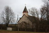 |
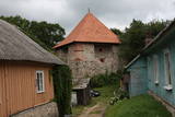
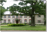
Nelielā izmēra ēka (balts ķieģeļu mūris, ar dēļiem apšūts zems tornis) atrodas Liepājas – Klaipēdas šosejas (A 11) malā. 20. gadsimta sākumā tā kalpojusi kā lūgšanu nams, taču tā paša gadsimta vidū pārbūvēta, uzceļot torni. |
|
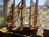 |
Laimonis and Ilga Veidemanis lived in Roja 20 or 30 years ago. They were deaf and loved to produce models of sailing ships of various sizes. This was based on a dream about the big ships of their ancestors and the wide seas upon which the couple could not sail. The models are very precise, designed with much care and love. The couple never learned the secrets of ship models, but their collection has been inherited by Laimonis’ granddaughter, who wants to display the wonderful collection and her grandfather’s careful work to the public. The hostess welcomes visitors and tells her story about how the models were produced. (Source: Roja TIC) |
|
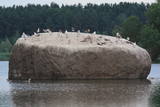 |
The Radžu stone is located to the South of Jēkabpils and at the north-eastern part of the Radžu sand and gravel quarry (the Radžu reservoir). The stone is the second largest rock in Latvia with a size of nearly 100 m3. At one edge of the quarry is the Jēkabpils Forest Park, which is popular among residents and their guests for leisure, hiking and sports. The beach of the reservoir was granted the Blue Flag in 2012. |
|
 |
This was an island after the Rīga hydroelectric power plant created a reservoir, and before that it was a peninsula on the Left Bank of the Daugava. During World War I, there were massive battles between Latvian Riflemen and a much larger German army on Death Island. On December 25, 1916, the Germans used poisonous gas against the Latvian troops. In honour of this, the architect Eižens Laube designed a monument to fallen Latvian riflemen on the northern shore of Death Island. It was unveiled in 1924. Death Island can be reached by boat, and the trenches and graves there are of interest. There is a pier for boats on the north-western shore of the island, and nearby is a location for leisure. Some of the trenches and dugouts have recently been restored. The battles were described by Aleksandrs Grīns in his masterpiece, “Snowstorm of Souls.” |
|
 |
The former building of the State Bank is at A. Pormaļa Street 11 in the centre of Jēkabpils. The 1931 building was erected in the style of Classicism, and the interior has been preserved to this very day. The Jēkabpils branch of the SEB Bank occupies the building at this time. |
|
 |
Lauku sēta ar pirti atrodas Merkys upes krastā, ciema nomalē meža tuvumā. Piedāvā programmu "Griķu ceļš no sēklas līdz galdam", iespējams nobaudīt tradicionālos ēdienus. Piedāvā arī nakšņošanu. |
|
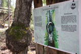 |
1,7 km gara lokveida taka, kas iepazīstina ar dažādiem meža biotopiem, to iemītniekiem un meža apsaimniekošanas pamatprincipiem. Apmeklētāju ērtības nolūkā ir izveidotas koka laipas un neliels skatu tornis. |
|
 2 days
|
This route is best for active hikers who want to travel down the valley of the mightiest river in the Baltic States to see lovely landscapes and feel powerful emotions. The route begins in Sigulda, which has been known as the Switzerland of Vidzeme and offers some of the loveliest views in Latvia. The route crosses the deep valleys of several Gauja River territory, offering a look at shores that are known at the Baltic level for their mighty Devonian cliffs. The nature trails in Līgatne are the only place in Latvia to see forestland that is close to natural circumstances, with forest animals living in large fenced areas so that they can be seen. There are also animals and tracks of their activities out in the wild as you walk down the forest and other trails of the Gauja National Park. Route information from Latvijas Lauku forums |
|
 |
Pussalas pils pirmsākumi ir meklējami 14. gs. Tajā laikā minētā pils bija viena no lielākajām šāda tipa aizsardzības pilīm. Pēc Traķu un Viļņas ieņemšanas 1382. g. pils kļuva par Ķēstutu (Kęstutis) - Lietuvas dižkunigaišu dzimtas dzīves un valdīšanas vietu. 1655. g. Polijas – Lietuvas lielvalsts un Krievijas kara laikā pili nopostīja. Līdz mūsdienām no iespaidīgās celtnes (aizņēma 4 ha platību) saglabājušās tikai no laukakmeņiem celtā aizsargmūra un torņu paliekas. Tās iekšpagalmā ir apskatāma efektīvā viduslaiku ieroča – katapultas atdarinājums. |
|
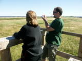 |
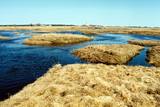
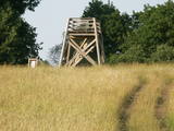
The key treasure in this park is that it has a lake that is one of the most intensive sites for birdwatchers in all of Latvia. It also features outstanding flora and the shallow waters of the Bay of Rīga. Recommended: Hike along the seashore from Mērsrags to Engure (20 km). See wild domestic animals (horses and cows) on the eastern shore of Lake Engure. There’s a bird-watching tower on the NW shore of the lake (approach from Kūļciems, where you can see domestic animals adapted to life in the wild, including the Blue Cows of Latvia). A bird-watching tower can be found at a place called Jomiņa near Mērsrags, where the seashore meadow is an uncommon biotope
|
|
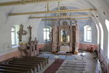 |
Храм построен в 1766 г., а колокольня возводилась в 1897 году. Орган, построенный в 1859 году органным мастером Ансисом Динсбергсом, считается старейшим органом Латвии работы латышского мастера. Запрестольный образ «Пасхальное утро» создан Янисом Розенталсом в 1912 году. Церковь можно осмотреть изнутри. |
|
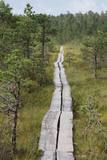 |
Ein 3,5 km langer Pfad quert den Viru Moos in Richtung Süd–Nord. Von einem Holzaussichtsturm eröffnet sich einen Blick auf eine typische Hochmoorlandschaft mit einigen Seen, Aushöhlungen und morastigen Stellen. |
|
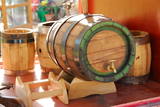 |
The craftsman manufactures barrels, hot tubs, furniture, stairs, doors and other useful objects. You can take a tour, learn about the relevant skills and experience, and help in manufacturing something that will be of use in the household. You can watch how barrels are made from start to finish, and also try your own hand at the craftsmanship. |
|
 |
This is one of Estonia’s most beautiful karst fields, covering 125 hectares which feature different karst processes – subterranean streams, the dry Jõelähtme River bed, karst streams, funnels, ditches, caves, cliffs, a unique rock “mushroom,” etc. During the spring, the field is flooded, but at other times of the year, its contents are easily visible.
|
|
 |
Jaunciems has always been a small village, and only a few homes are populated today. Nearby there are leisure locations on the right bank of the Irbe River. Jaunciems is linked to Sīkrags by the former tracks of the narrow-gauge train. There is also a bridge for hikers and bicyclists. |
|
 |
The owner of the farm grows petunias, geraniums, balsams, asters, snapdragons and other plants, also designing beautiful pots of flowers. She organises seminars on biological farming. Visitors can purchase plants, pick black currants from a bush, and pick tomatoes from a vegetable bed. Tastings are available, and there are rabbits on display, as well. |
|
 |
The Oak of Kemeri which grows in front of the Pienenīte
preschool on Tukums Street is of local importance and is
protected.
|
|
 |
Here the visitor will find an ecological tourism trail in the ancient Embūte valley. The hills around Embūte date back to the Ice Age. There are valleys and forests of many fallen trees which are protected habitats. The visitor will learn about important natural and cultural monuments – the Embūte castle hill, as well as the ruins of a baronial estate, a castle and a church. The Courlandian chieftain Indulis died in the region. The visitor can view the Devil’s Dam, along with meadows, a viewing tower, etc. There are bicycler routes in the region. The site is located in the Embūte nature park. |
|
 |
Farm is located ~1 km to the north of Puikule near to the former Limbazi railway, in the territory of North Vidzeme Biosphere Reserve. The farm breeds sheep of the Latvian dark-head breed from which wool, hats, scarves, souvenirs etc. are made by felting. They can be purchased in the farm. Sheep graze in nearby meadows, thus promoting plant diversity in the area. About the role of pets in maintaining biodiversity can also be read on the bench in the yard. In the barn house is a collection of household items. Visitors can take a guided tour and buy souvenirs. |
|
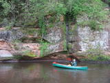 |
The Brasla River flows through a lovely valley that is approximately 300 m wide and up to 30 m deep. It is near the Inčukalns-Valka highway. The river has among the most beautiful rapids in the country, with mighty cliffs (the Brasla cliffs) that can be seen at nearly every curve in the river (except along the lowest reaches of the river). During the winter, various unusual frozen waterfalls can be seen in some of the cliffs, including the Krauļukalns cliff and the Jāņavārti cliff. On the left bank of the Brasla, opposite the Brasla fish farm, there are the Aņīte cliffs -- a series of sandstone cliffs that are 1 km long. The cliffs are between 2 and 35 m in height, and the sandstone cliffs are separated by ravines. On the right bank of the Brasla, there are major cliffs such as the Vāršavu cliff, the Kraukļukalns cliff, the Jāņavārti cliff, the Slūnu cliff, the Virtaka cliff and the Buļi cliff. How can you best learn about them? Boat down the river from the aforementioned highway or even from Straupe, which is further upstream. An alternative is hiking down the right bank of the river, though please take into account that the terrain is fairly extreme, and you are going to have to think about what to do when you arrive at the place where the Brasla River flows into the Gauja. |
|


