
| No | Name | Description |
|---|---|---|
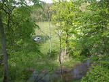 |
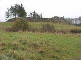
The viewing area is near the top of the Vilce castle hill, with a view of the Rukūze River valley, Zaķi meadow, and surrounding forests. This is an unusual landscape for the region of Zemgale. The Vilce baronial estate is nearby.
|
|
 |
A former pharmacy recalls the fact that Ķemeri at
one time was a spa of allSoviet importance. Symbols
devoted to the subject of pharmacies are still on the wall.
|
|
 |
The restaurant is at the Chocolate Museum in Pūre. The terrace offers a lovely view of the ancient Abava River valley. The men changes on the basis of the seasons and demand. Latvian cuisine: Chilled soup, sorrel soup, sautéed peas and carrots, liver stroganoff, oatmeal dessert, milk gelatine with berry sauce. Special foods: Dishes with Pure Chocolate products and garnishes. |
|
 |
The Lutheran Church of Krimulda is considered one of the oldest churches in Latvia. It was originally built in the 13th century, soon after the conquest of Kubesele and later rebuilt many times. Near the church a meditation labyrinth "Lily Flower" is set up. When Liv chief Kaupo fell during the battle at Viljandi in 1217, according to the legend, the ash was buried at the church. A small hill adjacent to Runtinupite (Runtins) is popularly known as a grave site of Kaupo, at its right bank is located ~7 m long, artificially dug Kubesele or Runtin cave. On the left bank of Runtinupite columns the Kubesele hill fort. Kubesele nature trail starts at the church. This trail leads to the Gauja River, where the Great (Runtina) stone lies. Here can be seen anchor pads installed by Gauja raftsmen. Krimulda medieval castle (4 km east of Krimulda Church) was built the second half of the 13th century in the place where the right bank of Gauja valley is split by deep ravine of Vikmeste. Castle (residence of Riga dome capitol - Riga's Archbishop Council) was an imposing building, whose big inner yard was included by 1.5 m thick defensive wall. In 1601, while retreating, Swedish military leader Heinrich Lieven blasted Krimulda castle. Now at the hill fort, grown with the forest a small castle ruins can be seen. Nearby is located air cableway and starts Krimulda mountain road. Located nearby Krimulda manor was first mentioned in writings in the 15th century. Present manor castle was built in the 19th century in neoclassical style (owner - First Lieven). During the twenties of the 20th century, the castle after its alienation became a property of the Latvian Red Cross, which established here children's sanatorium. Nowadays the castle houses rehabilitation hospital "Krimulda", but from the farm buildings, manor stables, barn, servant, manager houses and the so-called Swiss Cottage and Park have been preserved. Thematic tours are offered here. If we go down the Gauja by boat, then we will be able to take a close look at about 15 m high Velnalas cliffs. They can be well seen also from the opposite - left bank of Gauja (resting place is established). In the middle of the cliff about 19 m deep and 4.7 m high Krimulda Velnala cave is located. If we go from the Velnala cave cliffs along the lower part of the right bank of Gauja in Turaida direction, you will see Pikenes cliff, rich with sandstone outcrops. At its foot ~ 1 km long Pikenes beaver trail is established. The Little Devil's Cave (5 m long) is on the side of the trail, with the Gudribas (Wisdom) spring that springs out of the cave, as well as Aunapieres cave which is the same length as Devils cave. Small oxbow lakes also can be seen. |
|
 |
Beautiful views are accessible from the Sabile castle hill (steps, a location for relaxation), Upurkalns Hill (no improvements) and Briņķpedvāle, which part of the Pedvāle Open-Air Art Museum. There are also the Drubaži nature trails. The road between Kandava and Sabile which runs along the right bank of the Abava and the Aizdzire-Kalnmuiža road which runs on the left bank of the Abava also offer beautiful landscapes.
|
|
 |
The Eleja creamery offers tastings of cheeses from the farm that is run by the Mālkalns family (apply in advance for the tastings!). There are seven kinds of cheeses, including smoked and matured cheeses. There is French cheese that has been prepared in partnership with a French cheese-making specialist, M Eribert. Blūdži is in the Sesava Parish, 7 km from Eleja, and welcomes small groups. The farm bakes bread, processes vegetables (tomato juice) and prepares other country goodies. |
|
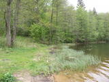 |
The most important aspect of the Sasaļi forest is the eutrophic Lake Sasalis, as well as the unusual Lake Melnezers. Also of importance are various types of forestland in the area. Lake Sasalis is a popular place for leisure and swimming.
|
|
 |
Atrodas Vecpiebalgas dienvidaustrumdaļā aiz baznīcas. 1340. - 1365. g. Rīgas arhibīskaps šeit uzcēla pili - cietoksni, ko apjoza aizsarggrāvji (atliekas redzamas arī mūsdienās). Pils ziemeļu pusē atradās priekštilta nocietinājumi, bet austrumdaļā - pils galvenā ieeja un tornis. Pili postīja 1577. g., bet pilnībā sagrāva 18. gs. |
|
 |
This arboretum park is in a lovely place – the Blue Hills of Ogre, where there is a tower with a good view of the Daugava River Valley. The landscape is enlivened by a pond and its streams. There are beautiful hiking trails throughout the park.
Unique species: The Amur Cork Tree (Phellodendron amurense) and the Field Elm (Ulmus minor), among others.
|
|
 |
Preiļu Siers is the largest cheese manufacturer in Latvia and exports 90% of its output. There are three “Preilis” stores in the town (Daugavpils Street 66A, Tirgus laukums 5, Rēzeknes iela 15) where are the widest range of Preiļu Siers products. Three kind of tastings of cheese "Čedars" produced in Preiļi, as well as "Čedars" cheese ice cream and a movie about the company are offered by local home producers "Pampūkas" beach terrace cafe, located in the active part of the city - beach area of Preiļi Park (pre-registration by phone 25867735, runs from the second Sunday of May till the second Sunday of September). In Preiļi , next to A/S "Preiļu siers" factory (Daugavpils iela 75) is one of few monuments to cheese in the world – the only one of its kind in Latvia. There are only four monuments for cheese in the world, two of them located in France, and one in each - Canada and USA. Therefore Preili can safely be called the cheese capital of Latvia. |
|
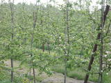 |
One of the loveliest apple orchards in Latvia (~10 ha, 30 types of apples) is on the sides of impressive hillocks. During clear weather, you can see the Bay of Rīga from atop the hillocks. The farm is particularly beautiful when apple trees are in bloom. Apples are available for tastings and purchase. |
|
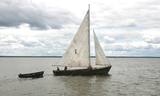 |
Kale is a traditional wooden sailing ship for trawling nets on Lake Võrtsjärv, but its graceful appearance with two triangular sails often inspired pleasure trips too. Võrtsjärve Foundation supported the building of the ship Paula, completed in 2005 and Liisu in 2009. Trips aboard a kaleship are a genuinely memorable experience. |
|
 |
The Šilute Estate is often described on the basis of its last owner, Hugo Scheu, who bought the estate in 1889. He restored the estate's buildings and territory, also installing two parks, one for the estate, and the other one known as the "raven forest." Alongside the estate is an English-type park with strolling trails. The park is used by local residents and is on both sides of the curvy Scheu River, with the banks connected by pedestrian bridges. He park stretches to an old railroad bridge and has approximately 150 types of plants, including 40 types of trees and shrubs. |
|
 |
Olustvere is one of the best preserved manor estates in Estonia. The building complex is set in landscaped grounds in English style with avenues of old trees. Collections of stuffed birds, hand-carved wooden horses with tools and antique furniture are exhibited in the complex. Other buildings and facilities include a distillery, a smithy and handicraft, wool, clay, ceramics and glass workshops where visitors can try their hand in various crafts. The mansion now houses a tourism centre. |
|
 |
Meklējams 0,3 km no Līvānu dzelzceļa stacijas – Fabrikas un Stacijas ielu krustojuma tuvumā. Ideja par Līvānu atbrīvošanas pieminekli radās jau 1929. g., taču to īstenoja 1935. gadā (arhitekts Pāvils Dreimanis). Tā galvenais elements bija 15 tonnas smags Krievijas armijas pamests lielgabala stobrs. 1958. gadā pieminekli iznīcināja, jo tas nebija „tīkams” padomju varai. No jauna to atklāja 2004. gadā. Piemineklis veltīts brīvības cīņās kritušo latviešu kareivju piemiņai, kuri 1919. g. ieņēma un atbrīvoja pilsētu no lieliniekiem. |
|
 |
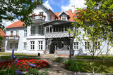
The castle was built during the first half of the 19th century in Tudor Neo-Gothic forms. The first owner of the castle was Baron Johann Gottlieb von Wolff. During the 1870s and 1880s it was rebuilt in the style of French Neo-Renaissance. The castle was burned down during the 1905 Revolution, but it was restored with certain elements of Art Nouveau forms. Tours are available of the interior of the building. |
|
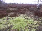 |
Baltijas mērogā unikāls dabas un cilvēkizmantots apvidus, kas veidojies kādreiz - padomju, mūsdienās - Latvijas Nacionālo bruņoto spēku pārvaldītā armijas poligona teritorijā. Poligona lielāko daļu aizņem smilšains vai ar zemiem lakstaugiem un krūmāju apaudzis kāpu masīvs ar atsevišķiem lielākiem kāpu vaļņiem. Rudens laikā šeit lielās platībās zied virši. Unikālā virsāju un aprimušo kāpu ainava un daudzu sugu dzīves vieta bija daži no iemesliem, kādēļ šai militārai teritorijai ir piešķirts arī aizsargājamas dabas teritorijas statuss. Jāatgādina, ka poligona apmeklējumi privātpersonām bez iepriekšēja saskaņojuma ir aizliegti!
|
|
 |
The farm offers a look at angora rabbits, which are very uncommon in Latvia. The owner offers tours, stories, rabbit wool, wool products such as mittens and socks, breeding rabbits and consultations. Children will love the animals and can feed them in the presence of the owner. |
|
 |
The magic kitchen offers tasty dishes from ingredients grown in the surroundings. Definitely try the nettle soup, which is recognised as the best soup of Southern Estonia. Nõiariik is suitable for active recreation for both families and larger groups of people. |
|
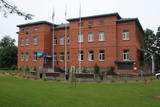 |
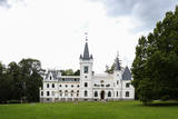
Muižas pils (no sarkaniem ķieģeļiem celta) ir meklējama ceļu krustojumā pie Gaujām – 2 km ziemeļaustrumos no Jaunpiebalgas centra, Gaujas labajā krastā. Līdz 1918. g. muižas īpašnieki bija slaveno grāfu Šeremetjevu dzimta. Muižas pili nodedzināja 1905. g. nemieros, bet vēlāk atjaunoja. Muižas pilī bijušas dažādas iestādes: slimnīca, kolhoza „Piebalga” administrācija, mūsdienās – pašvaldība un dažādu sadzīves pakalpojumu sniedzēji. |
|


