
| No | Name | Description |
|---|---|---|
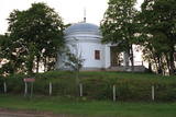 |
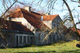
Varakļānu centrā, Rīgas ielas malā paceļas neliels paugurs, uz kura atrodas balta ēka ar 4 kolonnām un kupolveida jumtu, kas celta pēc Romas Panteona parauga. Kapela būvēta 1814. g. (arhitekts Vinčento Macoti), un tajā atrodas grāfu Borhu dzimtas apbedījumi. Kapelā bija novietoti arī Sv. Viktora pīšļi, kas pārvesti uz Varakļānu katoļu draudzes baznīcu. |
|
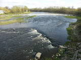 |
Above and below the town of Kuldīga, the Venta River is distinguished by a variety of biotopes – hillside forests, sandstone and dolomite cliffs, meadows, protected plants and animals, and diverse landscapes. There are popular tourism objects in this part of Kurzeme – the Venta dam, the stone bridge of Kuldīga, the Veckuldīga castle hill, etc. An ecological tourism trail runs along the banks of the Venta, and a bicycling trail has been installed on its left bank. |
|
 |
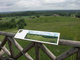
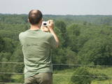
This is one of the most impressive and extensive natural structures of its kind in Latvia in terms of appearance and landscape. The ice age left behind this wall-like terrain, which is up to 27 metres high and at the top of which the Rīga-Ērgļi road has been built. The Great Kangari hills offer a view of the Great Kangars lake and the Great Kangari swamps and ponds. The Ķoderi castle hill, also known as the “Big Man’s Bed” is found here. The restricted area was established to protect the structure and its related biotopes and plants.
|
|
 |
It is said that Krišjānis Valdemārs began to dream about a port at this location when he was a child, but a so-called protective port was only established in Roja in the early 20th century, with a protective dam 500 metres from the shore that was 213 m long. The dam gradually disappeared, and the port was shut down in 1933. Work on straightening the Roja River began in the 1930s, using a French machine to create berms and build rock dams and pile-based breakwaters that were subsequently extended several times. In 1932, fishermen built a 107 m breakwater. Reconstruction of the breakwaters was completed in 1972. The fishing kolkhoz Banga used to be active here, merging shoreline fishermen’s homesteads. (Source: Roja TIC) |
|
 |
Place for bird ringing and bird watching. |
|
 2 days
|
Маршрут, для прохождения которого не требуется специальная подготовка, если его проходить летом. Абава – это река с самой впечатляющей древней долиной в Курземе. Она есть и остается «классикой» Курземе. На Абаве несколько выраженных стремнин, обычно в местах, где в ее русле и по берегам появляются небольшие обнажения доломитовых пород. На участке между Веги и Рендой падение реки уменьшается и она становится более спокойной. Информация о маршруте от Latvijas Lauku forums |
|
 |
This park is in a region of hillocks in the Karula highlands, and Lake Ähijärve is at its centre. The park offers a cultural environment of small farms, and it was set up to protect the unique cupola-shaped hillocks of the area. Main attractions: Scenic Lake Ähijärv (176ha), Rebasemõisa Tornimägi hill (137.8 m above sea level), undulating landscapes. |
|
 |
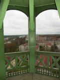
The tower offers a look at the historical centre of Limbaži , the castle ruins, and the landscape all the way to Lake Dūņezers. The Limbaži castle was part of Latvia’s earliest fortifications, and its unique gates survive to this very day. Keys to the tower can be found at the museum. This is part of the ZBR. |
|
 |
Café Ugandi is a cosy place in the very heart of Otepää, filled with a warm atmosphere, pleasant feelings, pure and delicious flavours. As soon as you arrive, you will feel the aroma of premium quality coffee and sweet pastries. The large showcase is filled with delicious cakes - you can enjoy them here or take them with you to enjoy later at home. |
|
 |
Celta 1933. g. vietējai brāļu draudzei. Baznīcā atrodas glezna “Kristus” (1850. g.) un Liepājas meistara Jēkaba Jauģieša 1920. g. darinātās ērģeles. Mūsdienās dievnamu izmanto Bārtas draudze. Pie baznīcas novietots akmens apkaimes represētajiem iedzīvotājiem. |
|
 |
Pupuchi ražotnē top kraukšķīga un veselīga uzkoda no cūku pupām - Pupuchi. |
|
 |
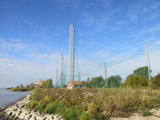
The forests of Zvārde are located on land which used to be a Soviet air base. The territory was unpopulated and was not accessible to civilians. The vast area includes various types of forest - boreal forest, bogs of black alder, etc. The fact that the military used to control the territory is one of the reasons why the forests of Zvārde are a location where many rare and protected birds live, reproduce and find food. Some of the elements of the old air base are still in place, including a unique surveillance platform. It is recommended that visitors to the area drive only along general use roads. |
|
 |
From the tower of St Simon’s Lutheran Church, you can see the central part of Valmiera and the banks of the Gauja River. During clear weather, you can see Zilaiskalns Hill. The church contains some cultural and historical treasures, as well as one of Latvia’s most resonant pipe organs.
|
|
 |
Matsalu muiža pirmoreiz vēsturiskajos avotos ir minēta 1560. g., kad tā ietilpa Lihulas bīskapijas sastāvā. Tagad redzamās ēkas ir celtas laikā no 18. gs. otrās puses līdz 20. gs. sākumam. Pagājušā gadsimta sešdesmitajos gados te plānoja izveidot Matsalu rezervāta centru, taču „veiksmīgā loze” tika netālu esošajai Penijē muižai (sk. iepriekš). Mūsdienās muižas pils, citas ēkas un parks (tajā dīķis ar salu) atrodas kritiskā stāvoklī. Taču kā nozīmīgu vēstures liecinieku arī šo muižu var iekļaut apskatāmo objektu sarakstā. Muižas komplekss atrodas pa ceļam uz Kēmu (Keemu) putnu vērošanas torni. |
|
 |
Information about this stream dates back to the mid-18th century, but people used it much earlier than that. People donated money to the stream after washing or drinking the water. During the first half of the 19th century, the baron of Tirza and the local church waged a battle against pagan traditions, though not very successfully. There is now a canopy over the stream, and people still drink its water. |
|
 |
The memorial site with a 1936 monument produced by the sculptor Kārlis Zāle is located in Smārde near the Smārde-Tukums road. It commemorates 38 soldiers who fell during World War I. Between 1915 and 1917, the front line was near Smārde. Many men were killed, and they were buried at the local swamp. It was only after the war that they were reburied in Smārde, Kūdra, Ķemeri, and Sloka. |
|
 3 days
|
The name of the Žemaitija region means "lowland." You will visit traditional and unusual farms to learn about gardening traditions and enjoy teas and herbs from a biodynamic farm. The lady of the house will teach you about traditional local foods. Next you will visit a place to discover the secrets of medicinal plants. An impressive exhibition about military history will be found at the Cold War Museum, which is on the territory of a former missile base. Then you will visit the Energy Labyrinth to enjoy peace and quiet while learning about how various geometric forms influence human emotions. Next you will visit a traditional farm with characteristic foods, beverages and songs. Along the way you will visit Telšiai, which is the informal capital of Žemaitija. Finally, you will visit a farm where traditional pastries are baked on a campfire, and a true Latvian sauna is offered. |
|
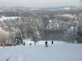 |
Gaiziņkalns Hill is the highest hill in Latvia, and it is a typical example of the hillocks of the Vidzeme highlands. This is a place of wonderful landscapes, even though there are not all that many good viewing areas. At the centre of this park is Gaiziņkalns Hill itself – the highest place in Latvia and the second highest in the Baltic States (311.6 metres above sea level). The viewing tower, alas is not open to the public, because it is in dangerous condition. There is a well-appointed hiking trail around Gaiziņkalns Hill, and during the winter the hill and its surroundings are popular for downhill and cross-country skiing. Lake Viešūrs (Lake Kaķītis) is popular among licensed fishermen. This territory is part of a region of protected landscapes around Vestiena. |
|
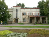 |
The building was erected during the first period of Latvian independence, and it maintained its functions for a long time. The building is located at Tukuma Street 30. Beginning in 1940, the post office had an automated telephone central. The Postal Service no longer uses it, and the building can only be viewed from the outside. |
|
 |
This is a route for hikers and bicyclists, starting at the village of Vaidava and then moving along the eastern shore of the narrow Lake Vaidava, which has steep cliffs around it. The trip covers the Veļķi baronial estate, the “Swedish pine”, the famous Vaidava (Metimne) hillfort, a series of streams, the great Rubene rock, the Vaidava baronial estate on the western shore of the lake. After that, the trail leads the visitor back to the starting point.
|
|


