
| Nr | Nosaukums | Apraksts |
|---|---|---|
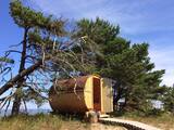 |
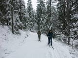
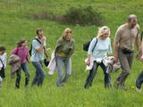
Piedāvājums nakšņot divvietīgās mucveida koka mājiņās pašā jūras krastā priežu kāpās Kolkasragā. Pavadiet neaizmirstamus vakarus vai brīvdienas Saules mājiņās ar mīļoto cilvēku vai draugiem pāris soļu attālumā no jūras, baudot relaksējošu dabu un saules peldes pašā Kolkasragā!
|
|
 |
Mājas restorāns mājīgā, autentiskā lauku vidē, kur tiek pasniegti lauku ēdieni, uz galda celtas svaigas jūras veltes, kuras atceļojušas no Francijas, Spānijas vai Norvēģijas, kā arī vietējās, pašu saimnieku kūpinātas zivis. Ēdienkarte tiek radīta katru dienu no jauna, kas ikdienā ļauj piedāvāt svaigus produktus.
|
|
 |
Žagares reģionālais parks organizē dažādas ekskursijas, izglītojošas programmas bērniem un senioriem un jauniešu nometnes. Žagare jau sen ir pazīstama ar savu īpašo ķiršu šķirni, kuru Latvijā pazīst ar nosaukumu ‘Latvijas zemais’, bet lietuvisko nosaukumu varētu tulkot kā ‘Žagares ķirši’. Tai ir vairākas variācijas, kas atšķiras ar dažādu nogatavošanās laiku, ražīgumu, augļu koku formu un citam pazīmēm. Līdz pat mūsdienām šie ķirši aug gandrīz ikvienās mājās un ir kā ekskluzīvs Žagares simbols. |
|
 |
Izstrādātā karjera teritorijā tiek piedāvāta labiekārtota atpūtas vieta pie ūdens ar 2 volejbola laukumiem, šūpolēm, ūdens batutu, piepūšamo atrakciju, grilvietām, galdiem un soliem. Atsevišķā karjerā tiek piedāvāta zivju zveja - foreles, karpas, palijas, sami u.c. Zivis šefpavāri uz vietas var Jums pagatavot, cept, uzvārīt zivju zupu. Zvejniecība notiek visu gadu. Papildu piedāvā ēdināšanas pakalpojumus. |
|
 |
Apmeklētāji var meklēt izeju 3300 m2 lielajā labirintā, izmēģināt spēkus, orientējoties un izpildot āķīgus uzdevumus kādā no labirinta īpašajiem līkločiem. |
|
 2 dienas
|
Šim maršrutam raksturīgs mainīgs kulināro garšu piedzīvojums, kas papildināts ar populārāko tūristu piesaistes vietu apskati Igaunijas Dienvidu daļā. Jums būs iespēja apmeklēt Võru un Rõuge, izbaudīt DienvidIgaunijas burvīgās ainavas Haanjas Dabas parkā, raugoties no Suur Munamägi (Lielā Munameģa) - lielākās augstienes Baltijā. Jūs sirsnīgi pārsteigs Setomaa, Setu zeme - etniska un kultūrvēsturiska minoritāte, kas turpina savas unikālās mantojuma tradīcijas. Setomaa apkārtne ir apdzīvota vairāk nekā 8 400 gadu, tādējādi tai kļūstot par vienu no vecākajām cilvēku apmetnēm Igaunijā. Šī maršruta laikā jums būs iespēja izgaršot Igaunijas vīnus, kas ražoti no vietēji audzētām ogām un augļiem, aplūkot kazu fermu, kur tiek piedāvāts izcils kazas siers un pasniegta sātīga lauku maltīte kārtīgā lauku sētā. Maršruta sākums un noslēgums ir Tartu, taču tas var tikt mainīts un pagarināts līdz vai no Tallinas un Rīgas. |
|
 |
Vecie kūdras karjeri – nākamā vieta
aiz Ķemeriem, kur jau daudz lielākā
apjomā (g.k. pirmās Latvijas brīvvalsts
laikā) tika iegūta kūdra.
|
|
 |
Viens no iespaidīgākajiem Igaunijas salu pilskalniem, ko ieskauj no akmeņiem veidoti vaļņi. Livonijas Indriķa hronikā minēta kā salinieku vislabāk nocietinātā apmetne. |
|
 |
Dabas parks, kas atrodas Ogres pilsētas ziemeļrietumu daļā, ir populāra ogrēniešu atpūtas, pastaigu, bet ziemā – distanču slēpošanas vieta. Parka lielāko daļu aizņem ar skujkoku mežiem apaugusi osu grēda (ledāja radīts veidojums – gara, salīdzinoši šaura pauguru virkne ar stāvām nogāzēm), kas ir nozīmīga daudzu augu sugu dzīves vieta. Viens no osu grēdas izteiktākiem pauguriem ir Jaunogres pilskalns - ar slēpēm un ragaviņām iecienīta nobraucienu vieta. |
|
 |
Viens no vecākajiem lībiešu ciemiem, kas pieminēts jau 1387. g. Senais ceļš no Dundagas muižas uz Sīkragu pastāvējis jau viduslaikos. 17. gs. Sīkragā bija viena no nozīmīgākajām sīkostām Ziemeļkurzemē, kurā ienākuši kuģi no Anglijas, Holandes un Lībekas, vedot ogles, labību u.c. preces. Pirms Pirmā pasaules kara darbojās piecas ķilavu kūres, 20. gs. 20. - 30. gados ciemā zvejoja ap 55 zvejnieku. Sīkragā dzimusi lībiešu kultūras darbiniece Hilda Grīva (Cerbaha, 1910 - 1984), tālbraucējs kapteinis Kārlis Anbanks (1884 – 1937), baptistu mācītājs Kārlis Lāceklis (1904 - 1970), lībiešu valodas un tradīciju zinātājs Pēteris Dambergs (1909 - 1987), dzimusi grafiķe Baiba Damberga (1957). Mūsdienās Sīkrags ir valsts nozīmes kultūras piemineklis. Ciemu šķērso Mazbānīša velomaršruts ar piemiņas akmeni stacijas vietā. Sīkrags tāpat kā nākamie ciemi austrumu virzienā atrodas Slīteres Nacionālajā parkā. |
|
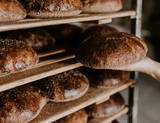 |
SIA N. Bomja maiznīca „Lielezers” atrodas Limbažos. Uzņēmums dibināts 1991. gadā. Maiznīca piedāvā dažāda veida rudzu maizes, kviešu maizes un konditorejas izstrādājumus. Maiznīcas “Lielezers“ lepnums ir īsta rudzu maize un sadskābmaize, kas ceptas pēc ilgas un darbietilpīgas tehnoloģijas. Pašu dzirnavās tiek malti Latvijā audzēti rudzu un kviešu milti, bet plaucējumi tiek diennakti nogatavināti pašu darinātajos apses koka kubuliņos un raudzēti ar ieraugu. Klaipus dala un veido tikai ar rokām. Maizes ražošanu vada pieredzes bagāti maiznieka amata meistari ar palīgiem - maiznieka amata zeļļiem. Tiek piedāvāts ražotnes apmeklējums un tikko ceptas maizes degustācija. |
|
 3 dienas
|
Šis ir viens no 6 ceļojuma maršrutiem sērijā "Baudi laukus!", un tas aicina apmeklēt Lauku Labumus – visdažādāko veidu un nozaru saimniecības un uzņēmumus, kas atvērti apmeklētājiem, piedāvā ekskursijas, nogaršot, apskatīt un iegādāties savus ražojumus. Tur apskatāmi mājdzīvnieki, mūsdienīgas lauku saimniecības, amatnieku darbnīcas, iegādājami lauku produkti – maize, medus, mājas vīns un alus, siers, ogas, augļi, zivis, gaļa, dārzeņi, tējas un citi laukos audzēti labumi. Pa ceļam iespējams ieturēt pusdienas lauku krodziņos. |
|
 |
Atrodas pie Jēkabpils apvedceļa (Rīgas virziens) – tirdzniecības centrā „Sala”, 0,2 km no mazās Daugavas. Omulīgas un telpas, kas dekorētas ar dabīgiem ziediem. Piedāvā maltītes visām ēdienreizēm. |
|
 |
“GREEN HIVE” ir pārtikas ražotāju uzņēmums, kas nodarbojas ar medus un ogu pārstrādi. Uzņēmums atpazīstams ar saukli “Medus citās garšās!”. “GREEN HIVE” piedāvā vairāk nekā 60 produktus – medu daudzās un dažādās garšās, kā arī sīrupus, sulas un nektārus. “GREEN HIVE” atbalsta zaļas Latvijas ideju, un ievēro šo pārliecību uzņēmuma ražošanas procesā, dzīvojot saskaņā ar dabu un lietojot dabas dotus produktus. Ražotnē uzņem tūristu grupas, produkciju iespējams degustēt un iegādāties. |
|
 |
Viens no izcilākajiem Baltijas karsta apgabaliem, kas aktīvi veidojas arī mūsdienās, pazemes ūdeņiem šķīdinot ģipšakmens iežus. Te aizvien rodas jauni zemes iegruvumi – karsta kritenes, par kurām klīst teiksmaini nostāsti. Plašā teritorijā ir redzamas arī citas karsta izpausmes – pazemes upes, karsta avoti, t.s. Govs ala (Karvės ola) u.c.
|
|
|
|
Ainavisks, ap 340 m garš un līdz 15 m augsts atsegums, kas atrodas nepilnu kilometru lejpus Raunas ietekas Gaujā, kreisajā pamatkrastā. To veido sarkandzeltenīgi Gaujas svītas smilšakmeņi. Gar Kazu ieža austrumu daļas pakāji izkaisīiti vairāki lieli laukakmeņi, kas ērti iekārtojušies uz smilšakmeņos izskalotas pamatnes. |
|
 |
Võrumaa pirmā mazā alus darītava ražo gardu alu, kas īpaši iekarojis Dienvidigaunijas iedzīvotāju sirdis. Ik pa laikam gatavojam arī Jevgeni ūdeni. |
|
 |
Dabas liegumā "Pilskalnes Siguldiņa" ir izveidota dabas taka - kājinieku tūrisma maršruts – t.s. Augšzemes ainavu taka, kas sākas Pilskalnē un beidzas pie Driģeņu mājām. Tā izlīkumo ezeru krastus, šķērso purvu (laipas). Apmeklētājiem, t.sk. arī bērniem, izveidotas arī īsākas - lokālas takas. Pieejami dažādu taku garumi: 1,6 km, 3,8 km, 8 km. |
|
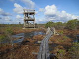 |
Atrodas 3,7 km garās laipu takas vidusdaļā. No torņa paveras viena no Latvijas izcilākajām augstā purva ezeriņu un lāmu kompleksa ainava. Tornis ir populāra saullēktu un ziemeļblāzmas fotografēšanas vieta. |
|
 |
Užavas alus darītavā, 20 km no Ventspils, tiek ražotas trīs alus šķirnes - Užavas GAIŠAIS, Užavas TUMŠAIS un Užavas ZIEMEĻU alus. Piedāvā grupu ekskursijas ar stāstu par šīs vietas vēsturi un alus darināšanas procesu. Blakus esošajā veikalā var iegādāties dažādu šķirņu alu un ar alu saistītus suvenīrus. |
|


