
| Nr | Nosaukums | Apraksts |
|---|---|---|
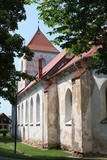 |
Atrodas Bauskas vēsturiskajā centrā, Plūdoņa ielā 13 a un ir šīs pilsētas daļas vecākā ēka. Dievnams celts 1591. - 1594. g. vēlās gotikas stilā, bet tornis piebūvēts 1614. g. Baznīcas iekšpusē atrodas nozīmīgi mākslas pieminekļi: altāris (1699. g., pārbūvēts 1861. g., mākslinieks J. Dērings), kancele (1762. g.) un ērģeļu prospekts (1766. g.) – abi Nikolaja fon Korfa dāvinājums, draudzes soli (17. gs. vidus – 18. gs. sāk.), senākais no koka veidotais Bauskas ģerboņa attēlojums (1640. g.), deviņas 16. – 17. gs. kapu plāksnes, epitāfijas u.c. Baznīca, kurā ir vērts ieiet! |
|
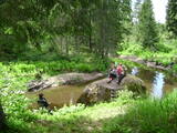 |
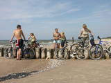
Gleznainajos Viesatas upes krastos variet iziet dabas takas un sarīkot pikniku dabā. Izstaigājot dabas taku būs iespēja apskatīt upes stāvkrastus, 200 gadu vecu priedi, brūno avotiņu, cūku vannu, bebru māju, mežizstrādes laukumu, melnalkšņu audzi, dižbērzu, Spuņņakmeni un daudzus citus objektus. Ja būsiet īpaši vērīgi, varēsiet ieraudzīt arī dažādu sugu putnus par kuriem informāciju varēsiet atrast takā izvietotajos stendos. Takas garums vienā virzienā ir 5,1 km, un to iespējams iziet 3 dažādos variantos. Taka ir marķēta un izstaigājama arī bez pavadoņa palīdzības. Lai izstaigātu visus upes līkumus, būs nepieciešamas 3 - 4 stundas. |
|
 |
Zemnieku saimniecība „Virši” audzē kaņepju sēklas, no kurām tiek iegūta kaņepju eļļa un kaņepju staks (apceptas, maltas kaņepes). ZS "Virši" produkciju ir iespējams degustēt dažādās vietās ārpus saimniecības, kā, piemēram, Kalnciema tirdziņā u.c. |
|
 |
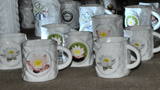
Baltijā lielākā keramikas fabrika. Tūristu grupām piedāvā ekskursiju pa ražotni. Blakus atrodas veikals, kurā var iegādāties keramikas izstrādājumus – gan praktiskas lietas, gan interjera priekšmetus un suvenīrus. |
|
 |
Kafejnīca "Krisdole" atrodas pašā Liepājas centrā, kafejnīca piedāvā svaigi ceptus gardumus no sezonāliem, saviem un vietējiem produktiem. Klasiskas un tradicionālas un jaunas un inovatīvas Kurzemes receptes. |
|
 |
Garšīgi, pašgatavoti konservi un citi kulinārijas izstrādājumi visiem, kuri novērtē vietējos ražojumus. Viesiem tiek pasniegti vietējie ēdieni, kā arī var iegādāties konservus līdzņemšanai. |
|
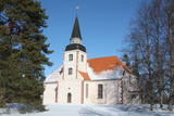 |
Dievnamam ir netradicionāls plānojums un izkārtojums: altāris atrodas vidū, bet kancele virs altāra. Baznīcai ir arī savdabīgs zvanu tornis ar 1634. g. lietu zvanu. Tagadējo koka interjeru veidojuši Rīgas amatniecības vidusskolas audzēkņi. Blakus baznīcai atrodas vecās baznīcas drupas un mācītājmuiža, kur 18. gs. nogalē par mājskolotāju strādājis Garlībs Merķelis, kurš Liepupē novēroto izmantojis savā nozīmīgajā darbā “Latvieši”.
|
|
 |
Āraišu ezerpils ir Eiropas mērogā nozīmīga 9. - 10. gs. seno latgaļu nocietinātas dzīvesvietas rekonstrukcija. Āraišu Arheoloģisko parku iespējams apmeklēt gan individuāli, gan grupās. Tiek piedāvātas ekskursijas gida pavadībā, dažādas izglītojošas nodarbības, kā arī programma jaunlaulātajiem. Tāpat tiek rīkoti dažādi tematiski pasākumi un amatu demonstrācijas. Parkā izveidots arī apmeklētāju centrs, kurā skatāma pastāvīga ekspozīcija. Tajā izzinošā veidā pirmo reizi kopš izrakumu veikšanas ir iespējams iepazīties ar tajos iegūtajām oriģinālajām liecībām, kā arī ar Jāņa Apala dzīves un ezerpils pētniecības stāstu. |
|
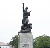 |
Atrodas Rēzeknes centrā, Atbrīvošanas alejas vidū. Latgales atbrīvošanas piemineklis “Vienoti Latvijai” ir piemiņas zīme vēsturiskā novada atbrīvošanai un Latvijas vienotībai. Bronzas pieminekli atklāja 1939. g. (tēlnieks K. Jansons, L. Tomašicka ideja). 1940. g. novembrī padomju vara centās to iznīcināt, bet pieminekli atjaunoja 1943. g. augustā. 1950. g. jūnijā sekoja otrais pieminekļa iznīcināšanas mēģinājums, kas bija veiksmīgs. Pēc Latvijas neatkarības atjaunošanas tautā saukto “Latgales Māru” trešo reizi uzstādīja 1992. g. 13. augustā (pēc saglabātajiem metiem veidojis K. Jansona dēls - A. Jansons). „Latgales Māra” ir uzskatāma par vienu no labākajiem Latvijas monumentālās tēlniecības paraugiem. Māras tēls tautas mitoloģijā tiek personificēts ar zemes auglību un dzīvības sargātājas ideju, bet krusts ir kristīgās ticības simbols. |
|
 |
Vietā, kur Gaujas senlejas labo pamatkrastu pāršķeļ vairākas mazu strautu dziļās gravas, izvietojies Turaidas muzejrezervāts ar Baltijas mērogā izciliem pieminekļiem, kuru vēsture iestiepjas 1000 gadu tālā pagātnē. Starp tiem ir jāmin Turaidasmuiža (21 ēka), Turaidas Rozes kaps, Turaidas luterāņu baznīca (viena no vecākajām (1750. g.) Latvijas koka baznīcām) un Turaidas pils. Blakus esošajā Dainu kalnā tiek organizēti dažādi tematiski pasākumi. |
|
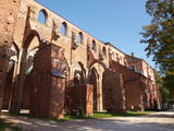 |
Viena no lielākajām Austrumeiropas baznīcām (līdz 16. gs.) un vienīgā Igaunijas viduslaiku baznīca ar diviem torņiem. Celta laikā no 13. – 16. gs., sagrauta Livonijas karā. Kora daļā atrodas Tartu universitātes muzejs (agrāk – bibliotēka). Torņi ir restaurēti un tajos izveidoti skatu laukumi. |
|
 |
Vēl nesen tas atradās bijušās Saukas vienības namā, kur bija izvietojusies Saukas arodskola. No 2010. g. ar kabinetu saistītā ekspozīcija ir pārcelta uz Saukas pagasta pārvaldes telpām Lonē. Mārtiņš Buclers (1866. - 1944.) bija Latvijas fotogrāfijas pamatlicējs, jo nodibināja valsī pirmo uzņēmumu, kas ražoja fotofilmas un fotopapīru. Muzeja eksponātus īpaši vērts ir iepazīt tagad - digitālajā fotolaikmetā! Pie Saukas vienības nama (tagad slēgts, apskate tikai no ārpuses) apskatāms M. Bucleram veltītais piemiņas akmens un piemineklis „Fotogrāfijai 150”.
|
|
 |
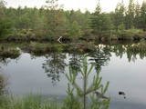
Nozīmīgākās vērtības ir seklais lagūnas tipa ezers – Papes ezers ar palieņu pļavām, Baltijas jūras piekraste, Nidas purvs un bagātīgā putnu valsts (konstatētas > 270 putnu sugas). Starp Papes ezeru un Baltijas jūru atrodas Latvijā vecākā (no 1966. g.) putnu gredzenošanas stacija, kurā ķer un gredzeno putnus un sikspārņus. Papes ezera apkārtne ir pirmā vieta Latvijā, kur ezera palieņu pļavu apsaimniekošanas nolūkā izlaida t.s. „savvaļas” zirgus („Konik” šķirne).
|
|
|
|
1996. g. atklātais piemineklis (tēlniece: A. Veinbaha) Dagdā (starp Asūnes un Rēzeknes ielām) ir piemiņas vieta komunisma terora upuriem. No šejienes paveras labs skats uz salām bagāto Dagdas ezeru. |
|
 |
Mākslinieka Jāņa Roņa izlolotā Piebalgas Porcelāna Fabrika ir vienīgā porcelāna ražotne Latvijā. Sākotnēji tika izveidota Porcelāna mākslas galerija Vecrīgā, darbnīca Kalnciema ielā un apgleznošanas studija Majoru kultūras namā. 2007. gadā aizsākas porcelāna ražošana Piebalgā, un šobrīd „baltais zelts” kļuvis par vienu no Piebalgas simboliem. Nelielā ražotne bijušajā Vecpiebalgas pienotavas ēkā attīstījusies par veiksmīgu uzņēmumu ar zīmolu Piebalgas Porcelāna Fabrika, kas ar neparastiem un oriģināliem mākslas priekšmetiem ieinteresējusi gan Latvijas, gan ārzemju tirgus. Rūpīgs roku darbs rada smalkus traukus, suvenīrus un īpašas dāvanas. Apmeklētāji aicināti paviesoties ražotnē, izzināt trauslā porcelāna tapšanas noslēpumu un izmēģināt porcelāna apgleznošanu. |
|
 |
Pirmā stacijas ēka
bija uzcelta jau 1877. g. līdz ar dzelzceļa atklāšanu.
Kādu brīdi stacijā pienāca vilciens Maskava – Ķemeri,
bet līdz 1920. g. no stacijas līdz Jaunķemeru pludmalei
kursēja tramvajs. 1. Pasaules kara laikā nopostīto
dzelzceļa stacijas ēku no jauna uzcēla 1922. gadā
(arhitekts A. Medlingers). Savulaik tā bijusi pirmā
Latvijas brīvvalsts laikā uzceltā būve Ķemeros. Stacijas
ēku vēlreiz pārbūvēja jau pēc 2. Pasaules kara. Stacijas
ēkā atrodas Ķemeru velonomas punkts.
|
|
 |
„Rīgas jūras līča rietumu piekraste” - nozīmīga patvēruma un barošanās vieta lielam skaitam migrējošo putnu sugu visa gada garumā. Biežāk sastopamās aizsargājamās putnu sugas – brūnkakla un melnkakla gārgale, jūrmalas dižpīle, kākaulis, tumšā pīle un mazais ķīris, teritorija ir nozīmīga arī rifu aizsardzībai. Teritorija atrodas iepretim Dundagas, Rojas un Engures novadam, kā arī Jūrmalas pilsētai, tās platība ir 132 173 ha. Teritorija ietver dabas parka „Engure” un Ķemeru nacionālā parka jūras daļu.
|
|
 |
"Rokdarbu lādes" veikaliņā ir apskatāmi un iegādājami Sabiles sievu darinājumi – adījumi un tamborējumi – cimdi, zeķes, cepures, šalles un citas noderīgas lietas, kas kalpos kā lieliskas dāvanas un suvenīri. |
|
 |
Apmēram 3 x 3 km liela teritorija ziemeļos no Kūdras ciema, kur atrodas t.s. Vecie kūdras karjeri. Te pirmās Latvijas brīvvalsts laikā ieguva kūdru. Mūsdienās teritorija ir aizaugusi, saglabājot vecos un applūdušos karjerus, kas kopumā veido ļoti savdabīgu ainavu. Tos vislabāk var iepazīt, dodoties (ar kājām vai velosipēdu) no Kūdras dzelzceļa stacijas pa ceļu, kas ved līdz Slokas ezeram. |
|
|
|
Labiekārtots Driksas (Lielupes atteka) posms ar divu līmeņu promenādi, Baltijas valstīs unikālo Mītavas tiltu, skatu vietām, piemineklis „Jelgavas students” u.c. |
|


