
| Nr | Name | Beschreibung |
|---|---|---|
 |
Находится в 2,5 км к северу от Круте. Небольшое здание из деревянных бревен с дощатой обшивкой первоначально было построено в 1642 году, а кирпичная башня восстановлена после Второй мировой войны. Интерьер церкви – алтарь (вторая половина XVII века), алтарная икона неизвестного автора «Иисус у креста» (XVII в.) и богато орнаментированная кафедра (1642 г.) являются важными памятниками времен маньеризма. |
|
 |
Das Kaļķupe – Flusstal wird geschützt, da der Fluss Pilsupe durch die Blauen Berge von Šlītere in den Süden nach Vīdale und Kaļķi fließt. Das ausgeprägte Flusstal hat ein verzweigtes Netz von Schluchten, in denen der Devonische Sandstein teilweise unbedeckt ist. Der Puiškalns – Hügel, der einst Burgberg und eine heilige Stätte in der Vergangenheit war , ist einer der markantesten Plätze in diesem Gebiet. Er ist ein beliebtes touristisches Ziel in der Region Talsi. Hangwälder, verschiedene Arten von Wiesen und eine große Zahl an Pflanzenarten sind ebenfalls wertvoll für die örtliche Umgebung.
|
|
 |
Erholungskomplex "Lejasmalas" befindet sich auf dem Ufer des Sees Lejas mit einem schönen Blick auf die Inseln. Lettgallische Gerichte aus den selbs angebauten Produkten. Lettische Küche: Gericht Buļbešnīki (auch mit Karotten), sieben Käsesorten, hausgemachte Würste (gekochte, gebratene, Blutwürste), Gericht Sekonkas (warmes Gericht aus Schweineorganen), Fischsuppe, geräucherte Fische, gefüllte Hechte, Fischfrikadellen, Birkensäfte, Hausbranntwein. Das besondere Gericht: Klöße von Aulejas. |
|
 |
Recreation place "Kaupēna mill" is located near Tērvete, Zemgale region. In the pension there is hall for celebrations, there is a garden with grill. Free private parking is available for guests. The kitchenette is fully equipped with crockery and cutlery, and there is a microwave. Turkish bath and terrace. The guest house has 15 beds for overnight stays. Guests are also offered a holiday house "Paradise House". It is a fully equipped family house with kitchenette and 4 beds, pond view, barbecue and gazebo. Quality well / spring drinking water. "Egļu namiņš" - the house has 5 beds, anteroom, terrace. Barbecue with terrace, next to the pond, WC, showers. We also offer 3 camping houses. 4 beds in each cottage. Toilets and showers are shared. |
|
 |
Befindet sich am linken Ufer des Flusses Venta, 0,1 km nordwestlich von der Brücke über der Venta auf der Landstraße Rīga–Liepaja (A 9). Es ist eine Wallanlage der Ahnen, auf der sich in den 14 – 18 Jahrhunderten eine Ordensburg befand (vernichtet im Großen Nordischen Krieg). Bis heutzutage ist es nichts davon geblieben. Ein auf der Wallanlage im Jahre 1987 errichteter Konzertpavillon ist heute ein populärer Veranstaltungsplatz. Der Konzertpavillon befindet sich inmitten des Parks mit den vom Bildhauer Ģ. Burvis errichteten Holzthronen der ersten Kurischen Könige. Es ist eine Aufsichtsplattform eingerichtet. Es besteht eine Sage über diese Wallanlage – sowohl über unterirdische Gänge, als auch über die Weiße Frau, die ein Mal pro 100 Jahre erscheint. |
|
 |
Die Bäckerei befindet sich 0,3 km südlich von dem Herrenhaus des Landgutes von Malnava. Die Wirtin bereitet nahrhafte lettgallische Gerichte vor und bietet ländliche Leckereien an. Gäste können zuschauen, wie Torten und Piroggen gebacken werden. Das Brot von Dzīles ist ein Symbol von Karsava. Hier werden der Brunch – das späte Frühstück – angeboten und kleine Märkte der lokalen Heimarbeiter und Handwerker organisiert. Lettische Küche: Lettgallischer Speck, Graupengrütze mit Zutaten, gefüllte Kartoffel mit Speck und Zwiebeln, geschmorte Gemüse mit Fleisch, Beerenbrot, Tee mit Honig. Das besondere Gericht: Selbstgebackenes Brot von Dzīles, dessen Teig Kleien, Rosinen, Moosbeerenmarmelade und Leinsamen beigefügt werden. |
|
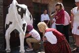 |
In der Kornkammer und in der Käserei des ehemaligen Landgutes von Sieksāte (Berghof) ist ein Museum (seit 1985) eingerichtet, wo man den Weg der Milchherstellung von der Kuh im Stall bis zu den fertigen Milchprodukten verfolgen kann. Jeder Besucher kann das Melken ausprobieren, Butter schlagen und das selbstgemachte Produkt verkosten. |
|
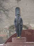 |
Opposite the tower of the Church of the Holy Trinity, the monument was designed by Arta Dumpe and commemorates Latvia’s first president, Jānis Čakste (1859-1927). It was consecrated on November 14, 2003, precisely 81 years after the statesman was elected to the important position. |
|
 |
Unweit von der Mündung des Flusses Kilmiņupe ins Meer befindet sich die sagenhafte Wallburg des Seeräubers Trommel – eine mittelalterliche Befestigungsanlage. Die ist etwa 100 m vom Hof „Kraujas” zu finden. Die 1977 hier während der archäologischen Ausgrabungen gefundenen Ziegelteile und Scherben von Ofentöpfen zeugen, dass die Befestigung schon im Mittelalter existierte. Dieser Ort ist mit den Sagen über den Seeräuber Trommel verbunden, der hier das Raubgut vergraben hat, deswegen sind an der Düne viele von den illegalen Archäologen ausgegrabene Gruben zu sehen. Eine Sage erzählt über den Seeräuber Trommel, der mit seinen Leuten die Schiffe in der Rigaer Meeresbucht von der Kurlands Küste bis zu der Insel Roņu raubte. Im Altertum ankerten hier viele Schiffe, die auf den günstigen Fahrwind warteten, um das Kap von Kolka umzugehen, aber der Seeräuber nutzte es mit einem eigensüchtigen Ziel aus. Er sammelte auch die Güter von den versunkenen Schiffen. Die Burg von Trommel wurde aus Stein gebaut. (Die Quelle: Roja TIZ) |
|
 |
Saldus ist in den historischen Quellen schon im Jahr 1253 erwähnt worden. Bis zum 13. Jh. befand sich hier die alte Burg der Kuren Salden, die auch im Wappen der Stadt dargestellt ist. Um 1341 hat der Livländische Orden unweit von dem Burgberg der Kuren eine Burg gebaut, an der sich eine Siedlung herausgebildet hat. Wie andere Ortschaften von Kurland hat Saldus ihre Blütezeit während der Regierungszeit des Herzogs Jacob von 1642 bis 1682 erlebt. Als das Gründungsjahr von Saldus wird das Jahr 1856 genannt, als mit den Erneuerungsarbeiten des im Nordischen Krieg zerstörten Ortes begonnen wurde. Am Ende des Zweiten Weltkriegs ereigneten sich in der Nähe der Stadt schwere Kämpfe, aber bis zum 8. Mai 1945 blieb die Stadt in dem Teil von Lettland, der von der deutschen Armee besetzt war. Heute zieht die Stadt Saldus mit ihren Veranstaltungen – mit den Stadttagen, mit dem Musikfestival Saldus Saule (Die Sonne von Saldus), sowie mit verschiedenen Sehenswürdigkeiten an, unter denen man die Druvas pārtika AG, wo man den Prozess der Eisherstellung beobachten kann, und die Saldus pārtikas kombināts GmbH nennen kann, wo man die leckeren Bonbons Gotiņa probieren und den Herstellungsprozess beobachten kann. |
|
 |
The territory has been established for protection of the bog and its habitat species. It is not appropriate for visits. North-east part of the bog can be slightly seen from the road Neveja – Lapmezciems on winter season. Further on Cirste direction is located on of most impressive oak trees in Latvia – Rigzemju ozols.
|
|
 |
Plungė ist berühmt für der Park der Fürsten Oginski. Der Park im gemischten Stil wurde im 18.-19. Jh. anstelle eines vormals heiligen Bannwalds eingerichtet. Prunkstück des Parks sind eine der ältesten und mächtigsten Donnereichen (Perkunaseiche) in Litauen, die legendenumwobene Weinende Weide, die fünfstämmige Esche. Auf Geheiß des Fürsten Oginski wurden 7 Teiche in Kaskaden angelegt, verbunden mit steinernen Schleusen-Brücken. Ein besonderen Akzent für die Landschaft setzt das durchfließende Flüsschen Babrungas. |
|
 8 Tagen
|
Wenn Sie einen aktiven Lebensstil genießen, ist diese Tour der perfekte Weg, um das im Gauja-Nationalpark verborgene Erbe aus verschiedenen Perspektiven zu genießen. Das Radfahren beginnt in Strenči und führt an zwei lokalen Brauereien in Brenguļi und Valmiermuiža mit schönen Cafés und gutem Bier vorbei. Sie wandern durch wunderschöne Wälder und entlang der Sandsteinklippe von Sietiņiezis in Richtung Cēsis mit seiner bezaubernden mittelalterlichen Altstadt. Kanufahren findet von Cēsis nach Līgatne statt, einem der schönsten Teile des Flusses Gauja mit seinen Sandsteinbänken, abgelegenen Gehöften und der altmodischen wasserbetriebenen Fähre. Das historische Zentrum von Līgatne ist mit der Entwicklung seiner Papierfabrik verbunden. Hier können Sie auch lokale Wein- und Handwerksproduzenten besuchen, die sich in einer der für die Region typischen künstlichen Höhlen befinden. Spazieren Sie auf den Līgatne-Naturpfaden, um lokale Wildtiere in einer Waldumgebung zu sehen. Am Ende radeln Sie von Līgatne nach Sigulda, einer der beliebtesten Sehenswürdigkeiten in Lettland. Sie sehen die mittelalterlichen Burgen von Turaida und Sigulda, die Gutman-Höhle und andere malerische Aussichten.
|
|
 |
„Pūpoli“ befindet sich an der Küste der Bucht von Riga, 50 Meter vom Meer entfernt. Die Besucher können dabei zusehen, wie Flunder, Zährten, Brachse, Barsch und andere Fische zubereitet und geräuchert werden, sie kaufen und verkosten. |
|
 |
Der Weg, der nach Biksere führt, erinnert an eine schmale Bergstraße mit einem tiefen Graben eines kleinen Flusses. Der frühere Namen von Biksere war Libes muiža (auch Lybei Hoff, Lybienhoff), die heute noch erhaltenen Gebäude gehörtem dem Gutsherrn Magnus. Der neogothische Turm des Herrenhauses wird in Kunstkenner-Kreisen als architektonische Kuriosität bezeichnet. Im Herrenhaus ist der Sitz der Gemeindeverwaltung von Sarkaņi. In der ehemaligen Scheune hat der Kunstliebhaber Andris Trečaks seine Antiquitätensammlung ausgestellt. Von der Scheune aus hat man einen wunderbar weiten Blick auf die tiefer gelegene Ebene von Lubāna. |
|
 7 Tagen
|
Auf dieser Tour erleben Sie, wie auf unterschiedlichen Weisen Milch als Lebensmittel oder als ein Produkt für Körperbehandlungen verwendet wird. Von Riga fahren Sie durch den historischen Kurort Jurmala bis Ziegenhöfen, wo Sie Käse, sowie ein exklusives Eis aus Ziegenmilch verkosten können. Danach besuchen Sie die Burg von Dundaga und verkosten Milchprodukte. In Roja erleben Sie örtliche Traditionen, indem Sie an einer Mahlzeit und Attraktionen mit Fischern teilnehmen. Weiter führt die Tour entlang der wilden Küste des Kaps von Kolka zu der gut gepflegten Stadt Ventspils, von der Sie weiter zu der malerischen Stadt Kuldiga mit ihrer gut erhaltenen hölzernen Architektur fahren. Diese Tour bietet die Möglichkeit an, den wunderschönen Milchhof kennenzulernen, wo Sie Spa-Behandlungen mit Milch genießen können. Hier befindet sich auch ein Milchmuseum, wo Sie den Weg der Milchherstellung von der Kuh bis zum Tisch verfolgen und auch einige altmodische Beschäftigungen wie z.B. Butterrühren ausprobieren können. Weiter wird die Tour süß. In Saldus besuchen Sie eine Fabrik, wo man traditionelle handgemachte Sahnebonbons verkosten kann. Danach ist auf der Speisekarte Eis in Druva. Als nächste Sehenswürdigkeit ist die Stadt Jelgava, die früher der Hauptsitz des Herzogs von Kurland war. Sie besuchen einen Käsehersteller in Eleja und vor der Rückfahrt nach Riga – das prachtvolle Schloss von Rundale, das als eine Perle des Baltikums angesehen wird. |
|
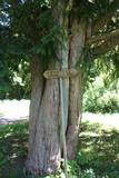 |
This is the thickest and tallest common ivy in Latvia. It is in the park of the Zentene Estate, opposite the mansion (which is now a school).
|
|
 |
No Vecās pasta ēkas ir redzama Sv. Jāņa kolonna. Domājams, ka tā celta 17. gs. un sākotnēji kalpoja kā blakus esošā tirgus laukuma „ziņojumu vieta”. Vēlāk kolonnu pārdēvēja Sv. Jāņa - zvejnieku aizbildņa vārdā, jo daudziem Traķu apkārtnes iedzīvotājiem zveja bija ikdienas dzīves sastāvdaļa. |
|
 13 Tagen
|
Die Strecke führt durch Jūrmala - den größten Kurort des Baltikums, den Nationalpark Ķemeri, eine urwüchsige Moor- und Sumpflandschschaft, und das Urstromtal der Abava (Naturpark). Entlang der Ostseeküste geht es weiter durch das zur Sowjetzeit nicht öffentlich zugängliche militärische Sperrgebiet (Liepāja Karosta - ehemaliger sowjetischer Kriegs- U-Boothafen) bis zur lettisch-litauischen Grenze. In Litauen führt die Strecke durch Žemaitija (Niederlitauen) bis Klaipeda am kurischen Haff. Von hier aus setzen Sie mit der Fähre auf die Kurische Nehrung über. Die Nehrung ist ein 98km langer Landstreifen zwischen dem kurischen Haff und der Ostsee mit den größten Wanderdünen Europas. Bahnfahrt Šiauliai - Rīga - größte Stadt des Baltikums - UNESCO-Weltkulturerbe. |
|
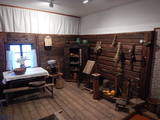 |
Die Exposition des Museums spiegelt drei Hauptbereiche wieder: Die Geschichte des ethnografischen Ensemble „Suitu sievas“, eine für die Region der Suiten typische Wohnzimmereinrichtung mit diversen Haushaltsgeräten, sowie alte Fotografien, die die Geschichte der Stadt wiederspiegeln. Auch für die Suiten typische Volkstrachten mit unterschiedlichen Details sind zu sehen. Dazu wurde eine Weberwerkstatt eingerichtet. (Der Name „Suiti“ kommt von dem der Jesuiten, Alsunga war die einzige katholische Region im ansonsten lutherischen Kurzeme. Viele ihrer Traditionen sind bis heute ungebrochen überliefert. Anm. d. Ü.) |
|


