
Reljefa formas
Kalni un pauguri
| Pārskats | Detaļas |
|---|---|
 |
Latvija
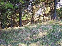
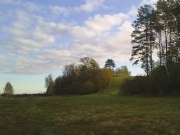
Nesaules kalnsDabas liegums veidots ar mežiem apaugušā lielpaugura – Nesaules kalna un tā apkārtnē esošo boreālo un mitro mežu aizsardzībai. Teritorija ir salīdzinoši grūti pieejama un nav labiekārtota apskates nolūkam.
|
 |
Latvija
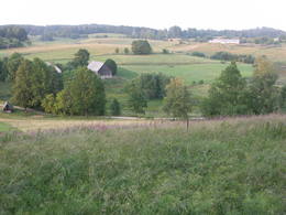
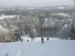
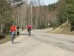
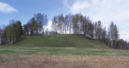
DēliņkalnsDabas liegums veidots Alūksnes augstienes augstākā lielpaugura – Dēliņkalna un tā nogāzēs esošo biotopu (nogāžu meži u.c.), kā arī apkārtējās ainavas aizsardzībai. Paugura nogāzēs izveidota kalnu slēpošanas trases un no tā dienviddaļas paveras izcila ainava. Dabas liegums atrodas Veclaicenes aizsargājamo ainavu apvidū (sk. sadaļu "Aizsargājamo ainavu apvidi").
|
 |
Latvija
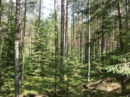
Numerenes valnisAp 25 km gara un līdz 1,5 m plata vaļņveida reljefa forma Adzeles pacēluma dienvidu malā, kas apaugusi ar skujkoku mežu. Latvijā reti biotopi un nozīmīga daudzu aizsargājamu augu un dzīvnieku sugu dzīves vieta. Numerenes valni var ļoti labi "izjust", braucot pa Kārsavas - Tilžas ceļu. Dabas parkā atrodas slēpošanas kalns "Nūmerene".

 320 320
Pakalpojumi
320km - Attālums no valsts galvaspilsētas |
 |
Latvija
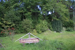
Šokolādes kalnsAtrodas ~ 1,5 km ziemeļos no Krāslavas centra, Jāņupītes krastā (ir norāde). Pēc atsevišķiem savrupatradumiem var spriest, ka pilskalns apdzīvots laikā no I g. t. pr. Kristus līdz vēlajam dzelzs laikmetam. Domājams, ka savu nosaukumu tas ieguvis šeit sastopamo mālu dēļ. Nelielas mālu ieguves vietas pilskalna nogāzēs ir redzamas arī šodien. Saglabājies nostāsts, ka grāfs Plāters šeit apraudājis savu sievu, kuru pats neuzticības dēļ licis iemūrēt pazemē. 265
Pakalpojumi
265km - Attālums no valsts galvaspilsētas |
 |
Latvija
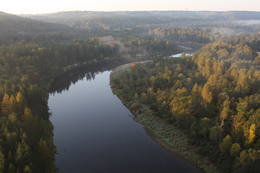
OliņkalnsDaugavas kanjons no Pļaviņām līdz Koknesei pirms appludināšanas bija viena no izcilākajām un skaistākajām Baltijas reljefa formām, bet Oliņkalns - viens no Latvijas lielākajiem pilskalniem, kura līdz 20 m augstā klints (Andreja klints) bija Daugavas kanjona sastāvdaļa. Pie Oliņkalna Daugavā pirms appludināšanas bija stipra krāce, kas apgrūtināja plostnieku darbu. Mūsdienās Oliņkalns ir neliela sala Pļaviņu HES ūdenskrātuvē (zinātājs pamanīs no Rīgas – Daugavpils šosejas (A 6) iepretim Stukmaņiem), ko no krasta atdala 0,3 km plata upes atteka, zem kuras dzelmē dus Dūņu leja. Uz salas saglabājies neliels pilskalna valnis, estrādes paliekas un dažus metrus augsts dolomīta atsegums – Andreja klints paliekas. Uzskata, ka Oliņkalnā 13. gs. atradusies Alenes pils. Pie Daugavas iepretim Oliņkalnam ir piemiņas akmens, ko 1989. g. uzstādīja Latvijas alpīnisti. 116
Pakalpojumi
116km - Attālums no valsts galvaspilsētas |
 |
Latvija
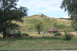
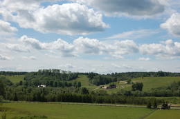
GaiziņkalnsGaiziņkalna apkārtne - Latvijas augstākā vieta ar Vidzemes augstienei raksturīgo pauguraino reljefu, izcila ainavu vieta, lai gan labu (vēl jo vairāk - labiekārtotu) skatu punktu nav nemaz tik daudz vai nav vispār. Parka „centrā” atrodas Gaiziņkalns – Latvijas augstākais un Baltijas otrs augstākais reljefa punkts (311,6 m vjl). Gaiziņkalna apskatei izveidota labiekārtota taka. Ziemas sezonā Gaiziņš ar apkārtni ir viena no Latvijas populārākajiem kalnu un distanču slēpošanas vietām. Kā licencētas makšķerēšanas vieta iecienīts ir Viešūra (Kaķīša) ezers. Teritorija ietilpst arī Vestienas aizsargājamo ainavu apvidū. Esot Gaiziņkalna dabas parkā, jāsecina, ka Latvijā ir liels ainavu potenciāls, kas šobrīd kā resurss praksē gandrīz netiek izmantots. Pakalpojumi
120km - Attālums no valsts galvaspilsētasPakalpojumi - atpūta
MakšķerēšanaViešūrā, Talejas u.c. ezeros saskaņā ar pastāvošo kārtību.

Kalnu slēpošanaGaiziņkalnā, "Lido kalnā".

Apvidus slēpošanaDistanču slēpošanas trase starp Kaķīša kalnu un Gaiziņkalnu, špūres Gaiziņkalna apkārtnē.

Slēpošanas inventāra noma
Dabas takaGaiziņkalna dabas taka (ap 2 km), Piekūnu klejojumu takas, Vestienas ekoloģiskā izziņas taka un dabas takas, kas izveidotas 2007. g./2008. g. mijā.

Dabas vērošanaG.k. ainavas vērošana, atsevišķās takās arī dabas - faunas un floras izziņa. |
 |
Latvija
Volzbaha kalnsVolzbahs ir stāva nogāze ar elpu aizraujošu skatu pāri gravai. Ziemā šeit pieejams vairāk nekā 100 m garš nobrauciens ar slēpēm, sniega dēli vai ragaviņām. Citos gadalaikos Volzbaha kalns ir lieliska atpūtas vieta- šeit ir labiekārtota vieta piknikam, pastaigām, foto sesijām. Rudenī Volzbaha kalns ir viena no labākajām vietām Vaiņodes novadā, kur vērot krāšņos rudens skatus. Volzbahs atrodas 2 km no Vaiņodes centra ZR virzienā. Kalnam ērti var piebraukt klāt ar automašīnām. Adrese: Vaiņodes pagasts, Dienvidkurzemes novads, LV-3435 Facebook: facebook.com/biedribavolzbahs Twitter: Volzbahs 190
Pakalpojumi
190km - Attālums no valsts galvaspilsētas |
 |
Latvija
Vīna kalns Daugavas ielejāAp 0,5 km ziemeļaustrumos no Stukmaņu muižas – Daugavas ielejas labajā krastā atrodas Vīna kalns – sens pilskalns. Tajā atrodas izpostītie Stukmaņu muižas īpašnieku kapi. Mazliet tālāk redzams klajš upes ielejas nogāzes posms, kurā savulaik darbojās slēpošanas trase. 114
Услуги
114km - Расстояние от столицы |
 |
Латвия
Karnicka kalnsKarņicka kalns pēc savas izcelsmes nav kalns, bet gan Daugavas ielejas nogāzes daļa ar labu skatu uz Krāslavas mazstāvu koka apbūvi. Ar šo vietu saistīts traģisks nostāsts par poļu virsnieka Josifa Karņicka un grāfa Plātera meitas mīlestību, kurai nebija lemts piepildīties tā laika „paražu” dēļ. Tā rezultātā abi nelaimīgie nolemj izdarīt pašnāvību. Virsnieks nošaujas, bet Emīliju pēdējā brīdī izglābj kalpone, neļaujot tai izlēkt pa pils logu. J. Karņicka pašnāvības vietā ir uzstādīts piemineklis. Nedaudz tālāk – rietumu virzienā guļ t.s. Austriņa akmens, pie kura 1909. gadā iedvesmojies un radījis latviešu rakstnieks Antons Austriņš. 262
Услуги
262km - Расстояние от столицы |
 |
Латвия
Grebla kalnsThis is another so-called hill left behind by the Ice Age – five kilometres long with a height of between 15 and 30 metres and with high hillocks and steep hillsides. Te most distinct part of the hill can be found between Lake Pinti and Lake Šeški. The pine forests on the hillocks are a habitat with many rare and protected species. A trail has been established to tour Grebļa Hill, as well as Āža Hill and Kausu Hill, but it is recommended that visitors travel the trail in the company of a guide. The biological diversity of the area is made clear if one knows, for instance, that more than 500 kinds of butterflies have been found in the restricted territory.
|
 |
Латвия
Гора Мицану-КиркасГора Мицану-Киркас. Маленький замок в Приежукалне в
1792 году был преобразован в лютеранскую церковь. До сих пор
гору называют „Кирха” (нем. Kirche – церковь). Пожилые люди
говорят, что под церковью был построен большой подвал, в котором хранились драгоценности семьи
Мантейфелей и церкви, в подвале находится семейный склеп Мантейфелей.
|
 |
Латвия
Горы Крачу (Крацкални)Горы Крачу (Крацкални) – цепь волнистых
холмов, сформировавшихся во времена
Литоринского моря под действием сильных
ветров. Прекрасный вид на Озеро лилий.
Напротив озера, с восточной стороны упомянутой
дороги по доломитной лестнице попадаем к
памятнику, установленному в честь 90 латышских
стрелков, которые пали в сражении 1917 г.
52
Услуги
52km - Расстояние от столицы |
 |
Латвия
Zviedru cepureSens pilskalns Abavas kreisā senkrasta nogāzē. Pēc sena nostāsta zviedru karavīri ar savām cepurēm to sabēruši virs sava ģenerāļa kapa. Tagad Zviedru cepures apkārtnē ziemā var braukt pa kalnu slēpošanas trasēm, bet vasarā – ar rodeļiem.
111
Услуги
111km - Расстояние от столицы |
 |
Латвия
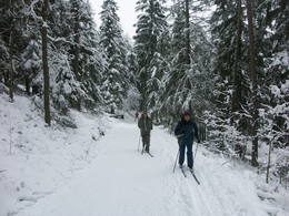
Ogres Zilie kalniThe nature park near the town of Ogre is a popular place for leisure, hiking and, in the winter, cross-country skiing. Most of the park is covered with coniferous trees that are on a long and comparatively narrow line of hillocks with steep sides – another element of nature left behind in Latvia by the Ice Age. Many different plants can be found here. The Jaunogres castle hill is one of the most distinct hillocks in the area. |
 |
Латвия
Urstromtal von GaujaEine der eindrucksvollen Reliefgestaltungen im Baltikum. Bei Sigulda erreicht das Urstromtal eine maximale Tiefe von 85 m ( Breite ung. 1 km). Schöne Sandsteinaufschlüsse aus dem Devon ist ein Anziehungspunkt. 40
Услуги
40km - Расстояние от столицы |
|
|
Латвия
Kvepenes pilskalnsIespaidīgs pilskalns ar izveidotu apskates taku. Blakus ūdenstūristu apmetne „Kvēpene”.
|
 |
Латвия
Zilais kalnsZilais (Blue) Hill is the highest point in the Idumeja highlands – it is a very distinct hillock covered by forest, and from it there is a “narrow” landscape featuring the northern part of the highlands, as well as the Burtnieks flatlands. The restricted area is there to protect habitats such as gullies, hillsides and the boreal (northern) forest of the area. Zilais Hill is a popular tourist destination.
|
 |
Латвия
ЛустужкалнсЛустужкалнс в 16 ст. на высоком холме
(72 м н.у.м.) находился охотничий замок
магистра Ливонского ордена Вальтера фон
Плетенберга. В свою очередь, построенный
во время Русской императрицы Екатерины
дворец развлечений, от которого и пошло
название и легенда о затонувшей золотой
карете в озере Валгума.
66
Услуги
66km - Расстояние от столицы |
 |
Латвия
Dievkalns HillWhere the little Rumbiņa river flows into the Daugava (on the left bank of the little river opposite the Lielvārde park), there is the Dievkalns castle hill that has been reduced by the waters of the Daugava. It is also known as the Cepure hill. According to antiquities that have been found here, representatives of Baltic tribes lived here from the first millennium BC to the 6th or 7th century AD. The level of the Ķegums hydroelectric power plant can be reached by a staircase from which the best view of this object can be found.
56
Услуги
56km - Расстояние от столицы |
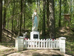 |
Латвия
Городище МилкасГородище Милкас находится на северном берегу залива западной
части озера Салайс, неподалеку от истока реки Малты. Гора поднимается
на 27 м над уровнем озера. Склоны городища крутые одинаково, только
восточная сторона более покатая. Местный предприниматель привел в
порядок городище и установил на нем статую Богоматери, свидетельству-
ющую о вере местных жителей Богоматери и убежденностью в существование Бога.
273
Услуги
273km - Расстояние от столицы |
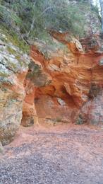 |
Латвия
Sarkanās klintis un RūcamavotsSarkanās klintis savu vārdu ieguvušas pateicoties sarkanajiem iežiem. Tieši sarkanā ir mīlestības krāsa, tāpēc sarkanās klintis ir romatiska pastaigas vieta mīlniekiem. Smilšakmens klintīs redzamas plaisas, kas sašķeļ sarkanīgos iežus, radot neparastu dabas mākslas darbu. To virsma ir diezgan izrobota, kas veido klintīs nelielas alas un nišas. Sarkanajās klintīs ir arī daudz dažādu avotiņu. Pazīstamākais no tiem ir Rūcamavots. Tam ir šāds nosaukums, jo tas, nākot ārā no zemes, izdod nelielu rūkoņu. 74
 1-12 1-12
Pakalpojumi
74km - Attālums no valsts galvaspilsētas
1-12 Aktīvie sezonas mēneši |
 |
Latvija
Kuršu pilskalnsArī Senču pilskalns, Baznīckalns un Velna gulta. Pirmo reizi minēts 1230. gadā kā viens no senās kuršu zemes Vanemas centriem. Ar šo objektu var sākt Abavas senlejas skaistāko skatu apzināšanu. Līdz pilskalna plakumam ved kāpnes, un no tā redzami senlejas vārti un upes ielejas kreisā krasta nogāze, kuras piekājē izvietojusies Jaunkandava.
97
Pakalpojumi
97km - Attālums no valsts galvaspilsētas |
 |
Latvija
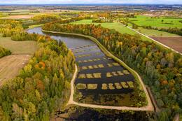
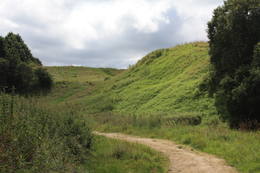
Lielie KangariVizuāli un ainaviski iespaidīgākais un lielākais Latvijas oss - ap 26 km gara, šaura un stāva, līdz ~ 27 m augsta, ledāja veidota vaļņveida reljefa forma pa kuras augšdaļu ~ 7 km garumā uzbūvēts Rīgas – Ērgļu ceļš. No Lielajiem Kangariem paveras skats uz Lielo Kangaru ezeru un Lielkangaru purva akačiem. Uz osa atrodas Ķoderu pilskalns - Lielā vīra gulta. Dabas liegums veidots osa un ar to saistīto biotopu un augu sugu aizsardzībai.
|
 |
Latvija
Rasnupļu (Opiņķu) pilskalnsRasnupļu (Opiņķu) pilskalns ir nozīmīga seno latgaļu apdzīvotā
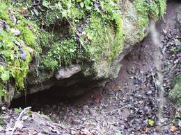
vieta tā pakājē. Vīces strauta labajā krastā izveidojusies Velna ala,
saukta arī par Latgales mazo Staburagu. Nelielā ala (garums 3 m, platums
2 m, augstums 0,6 m) ir ģeoloģiski unikāla, jo izveidojusies,
dabiski sacementējoties kvartāra perioda grants iežiem. Šādas alas
Latvijā ir tikai divas. Alā ir 5 – 6 cm gari stalaktīti.
|
 |
Latvija
Aizkraukles pilskalnsAtrodas Daugavas labajā krastā, ap puskilometru no Skrīveru Zemkopības institūta. Šajā vietā stāvo Daugavas ielejas krastu „pāršķeļ” dziļā Ašķeres strauta grava. Pilskalns bijis apdzīvots jau no 1. g. t. pr. Kr., par to liecina tajā atrastas latgaļu un lībiešu senlietas. 13. gs. pilskalnā slējās mūra pils, ko nopostīja 17. gs. Par tās esamību mūsdienās nekas vairs neliecina. No pilskalna, ko dēvē arī par Kraukļu kalniem, paveras viens no skaistākajiem Daugavas vidusdaļas skatiem. No tā (Rīgas virzienā) redzama Senbaznīcas vieta (attīrīts laukums ar baltu krustu). Gar Ašķeres strauta krastiem izveidota pastaigu taka. Tuvākā pilskalna apkārtne ir labiekārtota, kopumā ir izveidotas četras takas. Garākā no tām ir Daugavas taka (10 km). 81
Pakalpojumi
81km - Attālums no valsts galvaspilsētas |
 |
Latvija
Mazie KangariPēc izmēriem, salīdzinoši ar Lielajiem Kangariem, - mazāks oss. Ap 10 km garie un līdz 16 m augstie Mazie Kangari izlokas gar Buļļu purvu. Dabas liegums veidots osa, Buļļu purva, dažādu mežu tipu un reto augu sugu aizsardzībai. Uz osa izveidota auto apstāšanās vieta.
|
 |
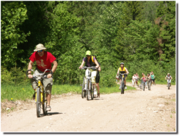
Latvija
Talsu pauguraineDabas parks ir izveidots Ziemeļkursas augstienes Vanemas pauguraines izteiktākās un ainaviskākās daļas – Talsu pauguraines aizsardzībai. Šis ir viens no ainavas ziņā skaistākajiem Kurzemes apvidiem, kur nelieli, bet izteikti pauguri mijas ar starppauguru ieplakām, kurās izvietojušies mazi, bet samērā dziļi ezeriņi – Ābeļu ezers, Čumals, Sirdsezers u.c., no kuriem daži atgādina dziļus krāterus. Teritorija piemērota aktīvā tūrismam – pārgājieniem, velobraucieniem u.c. Leistungen
115km - Entfernung von der HauptstadtLeistungen - erholung
RadrouteŠobrīd ieviešanas stadījā.
NaturpfadSkaņu takas Talsu mācītājmuižā, folkloras taka "Jāņkalni" (1,5 km), pastaigu takas Kamparkalnā un Vanagkalnā. Vēlams izmantot vietējo gidu pakalpojumus.
NaturbeobachtungAinavas vērošana no pauguru virsotnēm, skatu torņa.
|
|
|
Lettland
Pusenu kalnsОдна из наиболее высоких дюн нашего побережья. В советское время в дюне велись копательные работы, так как песок использовался для производства силикатного кирпича. В 80-е годы ХХ века копательные работы были прекращены. Самая высокая часть дюны (хороший вид) сохранилась и поросла сосновым лесом. Создана природная тропа горы Пусену. Находятся в Бернатском природном парке. 232
Leistungen
232km - Entfernung von der Hauptstadt |
 |
Lettland
Idena Castle moundĪdeņa Castle mound is located near Lake Lubāns. A beautiful view
to the lake and to the marshy meadows. The place was inhabited from
the 11th century.
|
 |
Lettland
The castle hill of SpringiThe castle hill of Spriņģi. It is located near Rēzekne town and it is
interesting with its peculiar shape of the ruins.Archeological monument of local significance.
|
|
|
Lettland
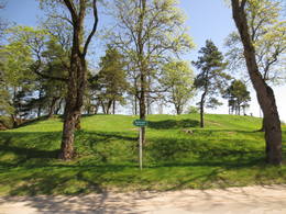
OpekalnsOpekalns (arī Apukalns, Opekols) ir paugurs Alūksnes augstienē, 235 metrus virs jūras līmeņa, Veclaicenes pauguraines viena no augstākajām virsotnēm. Tā virsotnē uzcelta Opekalna luterāņu baznīca (1774—1779), kas ir visaugstāk virs jūras līmeņa novietotais dievnams Latvijā. Opekalna ciemā dzimis leģendārais Dziesmu svētku virsdiriģents Haralds Mednis. 166
1-12
Leistungen
166km - Entfernung von der Hauptstadt
1-12 Aktive Saisonmonate |
 |
Lettland
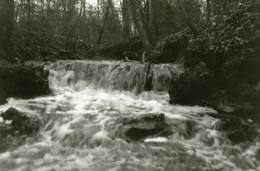
Kalamecu-Markuzu gravasHier gibt es einige “canyon-ähnliche” Schluchten zwischen den Dolomitablagerungen. Man findet interessante Aufschlüsse und kleine Wasserfälle im kleinen Flussbett.
|
 |
Lettland
Dizgabalkalns HillIs an ancient Courlandian castle hill and is found in the very centre of Alsunga. It was named in 1659 when General Berg from Kurzeme put cannons on it to attack Swedish forces that had fortified themselves in the Alsunga castle. The hill is 8 to 10 metres high and 24 x 54 metres wide, offering a lovely view of the St Michael Roman Catholic Church, as well as the Alsunga windmill lake that is alongside it. There is a distinct terrace around the hill, and it once was the foundation of wooden defensive structures. On the other side of the street, to the West of the castle hill, is a cemetery with fire graves of Courlandians that date back to the 11th to 13th century. Archaeologists examined the area during the middle part of the last century. The Suiti celebrate Easter and other holidays on the hill. 185
Leistungen
185km - Entfernung von der Hauptstadt |


