
| Нo | Название | Описание |
|---|---|---|
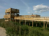 |
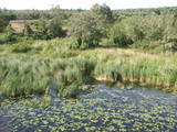
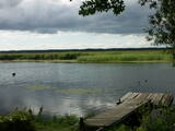
This is the only viewing platform in Latvia which is wheelchair-accessible. From the second level, you can see much of the restricted territory – areas of reeds, some wetlands, dunes and the estuary of the Daugava River. This is a good location for bird-watching.
|
|
|
|
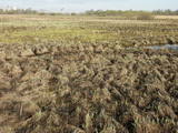
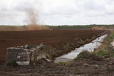
Atrodas Sedas purvā (Sedas dabas takas malā) ar plašu skatu uz izstrādātajām kūdras platībām. Sedas taku ieteicams izstaigāt vietējā gida pavadībā T: + 371 2636162. |
|
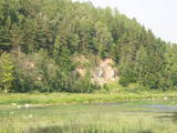 |
One of the most beautiful areas along the Venta River and its tributary, the Šķērvelis River. The river valleys and gullies along them are quite deep, and dolomite and sandstone cliffs can be spotted here and there. There are also rapids on the river. The largest cliffs in Kurzeme – the Ātraiskalns and Gobdziņi cliffs – can be seen on the banks of the Venta. The Lēni Catholic Church is near the restricted area. There are no tourist elements in the restricted territory at this time. The Venta is a popular destination for water tourists, however, from Nīgrande to Kuldīga. |
|
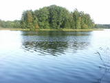 |
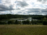
This restricted area protects Lake Jumurda, which is in the central part of the Vidzeme highlands, along with its three islands, the local broadleaf forests, and the surrounding landscapes.
|
|
 |
Along with the Nagļu ponds, these are Latvia’s largest fishing ponds. They were established on the flood-land peat areas of Lake Lubāns in the 1970s, when the hydrotechnical system of the lake was first established. The Lubāna-Gaigalava road bisects the Kvāpāni-Īdeņa ponds. There are three bird-watching towers on the dams of the ponds. The ponds are a major location for water bird nests, as well as places for migrating birds to rest. There are extensive bird-watching opportunities in the area.
|
|
 |
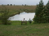
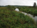
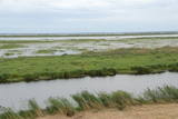
Natural flood-land meadows along the banks of the Lielupe before Jelgava. Many protected plants are found here, and birds nest and rest here during migration season.
|
|
 |
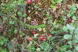
Nature restricted area is established to protect various wetland habitats – Big Kirba Bog and protected plant species within it. Only the West part of the Bog is a protected nature area. The rest of the bog is used mainly for intensive extraction of peat and large cranberry cultivation. Nature restricted area of the bog has no tourism infrastructure therefore is not useable for tourist visits.
|
|
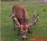 |
he wetland meadows that are around the Pededze River are the site of this 200 ha farm with some 350 red deer, other deer and wild boar. There are towers from which you can watch the graceful animals, and there are ponds for commercial fishing. Please contact the owner well in advance for a tour. |
|
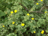 |
This is a swamp into which sulphurous waters flow, and it is on the left bank of the Abava River valley. This is the only place in Latvia where the protected shrubby cinquefoil is found in the wild. This bush covers approximately one-fifth of the restricted territory. It also includes forests, various kinds of meadows and sulphurous streams, including the one which is known as the Devil’s Eye. |
|
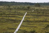 |
The tower is in the western part of the Vasenieki swamp, and an interesting nature trail with information stands and pathways was recently established there. The tower offers a look at unique swampland – visitors can survey the entire swamp. Wear proper footwear when it is damp outside!
|
|
 |
These are hillocks at the northern end of the Vidzeme highlands, and this is an important location for boreal (Northern) forests and swamps. Various kinds of swamps are found here, and the area is home to a variety of protected invertebrates.
|
|
 |
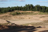
This territory covers the shoreline between the Ventspils-Liepāja highway and the Baltic Sea on both sides of the Užava River. The territory was established to protect shoreline biotopes such as the grey dunes, as well as a number of endangered plants. To the South of the mouth of the Užava River we find one of the most romantic lighthouses in Latvia – the Užava lighthouse, which is at the top of a steep dune. |
|
|
|
Atrodas Liepājā, E. Tisē un Lauku ielas krustojuma galā. Pa Ezera laipu (Liepājas ezera palieņu pļavas) var nokļūt līdz putnu vērošanas tornim, no kura labi pārlūkojama ezera ziemeļdaļa. Laba putnu vērošanas vieta. Ietilpst Liepājas ezera dabas lieguma teritorijā. |
|
 |
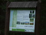
Palieņu pļavas starp Rūjienu un Rūjas ieteku Burtnieku ezerā, kurām raksturīga liela augu un putnu sugu daudzveidība. Tās robežojas ar bijušiem Rūjas zivju dīķiem, kas šobrīd aizaug ar mežu. Rūjas palienes var vērot gan braucot ar laivu pa Rūju, gan arī no ceļa, kas ved uz minētajiem dīķiem. Tur izvietots informācijas stends.
|
|
 |
This is a territory which regularly floods when the Lielupe River crosses its banks. These are flood-land meadows of importance to birds. The area can be surveyed from the Rīga-Liepāja highway and the Kalnciems road which runs along it. |
|
 |
The territory has been established for protection of the bog and its habitat species. It is not appropriate for visits. North-east part of the bog can be slightly seen from the road Neveja – Lapmezciems on winter season. Further on Cirste direction is located on of most impressive oak trees in Latvia – Rigzemju ozols.
|
|
 |
Ilziņš jeb Vestienas dzirnavezers pazīstams ar nostāstiem par tajā "periodiski uzpeldošām kūdras salām". Saskaņā ar vietējo iedzīvotāju sniegtajām ziņām, minētā parādība gan sen jau vairs nav novērota. Tajā pat laikā ezers un tā apkārtne ir nozīmīga daudzu aizsargājamu biotopu un sugu dzīves vieta. Ezers ietilpst Vestienas aizsargājamo ainavu apvidū. Ezeru var redzēt, braucot pa Ērgļu - Gaiziņkalna ceļu. Var pakāpties arī blakus esošajā paugurā (ziemeļos no minētā ceļa un ezera), no kura paveras plašāka skatu perspektīva.
|
|
 |
Dabas liegums atrodas dienvidaustrumos no Lubāna ezera un tas veidots purva un meža biotopu un tajos esošo sugu aizsardzībai. Gar teritorijas ziemeļu robežu iet Nagļu - Degumnieku ceļš (iekļaujas kopējā Lubāna dambju sistēmā), pa kuru apkārt Lubāna ezeram izveidots velomaršruts. Tas nozīmē, ka teritoriju var aplūkot arī "no malas", netraucējot tās dabiskās norises. Teritorija ietilpst arī Lubāna mitrāja kompleksā.
|
|
 |
This is a large set of coastal meadows, ancient rivers and areas of reeds. It is found at a location where the Daugava River used to flow – between Vecmīlgrāvis and Vecāķi. There are inland dune meadows here, complete with the very rare silver grass. Vecdaugava is an important location for nesting birds and several uncommon plant species. On the southern end of the Vecdaugava peninsula, at a place called Skanstnieki, one can find remnants of medieval Swedish fortifications. The Vecdaugava Regional Research and Fishing Museum is here, as well.
|
|
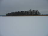 |
There are six islands in the Great Baltezers lake – the Auzu, Priežu, Mazā, Liepu, Ropažu and Meldru islands. These are distinguished by a great diversity of plants, including forests of broadleaf trees, black alders and pines. The territory can be surveyed quite well from the side of the Ādaži Lutheran Church. The Great Baltezers lake is a popular place for fishing, including ice fishing during the winter.
|
|


