
| Нo | Название | Описание |
|---|---|---|
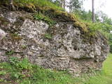 |
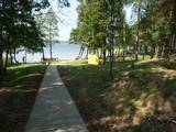
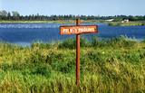
This is a segment of the Gauja River which is full of rapids in some places. It stretches from Vidaga and the place where the Vecpalsa River flows into the Gauja. Along the Gauja and its tributaries, dolomite outcrops can be seen on the shores, and the largest of these are the Randati cliffs. The restricted area was established mostly to protect various kinds of forests, meadows, outcrops and their habitats. This is an interesting part of the central section of the Gauja for people who enjoy beautiful landscapes and for those who are water tourists.
|
|
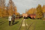 |
Sedas purva kājnieku maršruts atrodas dabas liegumā Sedas purvs, pārgājienu pa maršrutu iespējams apvienot ar Sedas pilsētas apskati, kas ir unikāls 20.gs. 50.–60. gadu pilsētbūvniecības un arhitektūras paraugs - kūdras purva strādnieku pilsēta. Maršrutam ir divi apļi - Jērcēnu aplis - 5,5 km un Sedas aplis - 4,2 km. Tajos apakatāms izstrādātais kūdras purvs, šaursliežu dzelzceļš, ritošais sastāvs, divi skatu toņi. Rudenī un pavasarī - putnu migrācijas lāikā - interesanta vieta putnu vērošanai. GPS koordinātes: Jērcēnu puses aplim: 57.7055987, 25.7001324; Sedas puses aplim: 57.6699587, 25.7514815. |
|
 |
Relatīvi grūti pieejama un cilvēka mazskarta teritorija kūdrā izstrādātajā Cenas tīreļa ziemeļaustrumu daļā, kur saglabājušies augstā purva biotopi ar purva ezeriem, kas kopumā veido nozīmīgu vietu ligzdojošām un migrējošām zosveidīgo, tārtiņveidīgo u.c. putnu sugām. Teritorija nav piemērota (un nav vēlams) tūrisma aktivitātēm.
|
|
 |
One of few places in Latvia (around 1 km to the North from Lapmezciems) where used to be beautiful juniper meadows. Since no agriculture activity (grass cutting, cattle grazing) has been implemented in the area, juniper meadows are overgrowing and disappearing. To save the area sustainable management is needed. Slitere National Park with Blue Mountain cliff and Slitere lighthouse is located in short distance from Kadiku nora (Juniper meadow).
|
|
 |
There is a small and relatively hard to reach area on the western shore of Lake Būšnieks which has been restricted to protect swamp habitats and several protected plants. Boat base is on the northern shore of the lake offers boat rental. From the plank-way good sites of eutrophic part of Lake Būšnieks can be seen. A well-appointed recreational facility (not included in the restricted area) is on the opposite shore of the lake. |
|
 |
The only island in Lake Ciecere has a more or less virgin forest of oak, linden and elm. Some of the oaks are huge. This is an important habitat for woodpecker-type birds. The island has not been improved. |
|
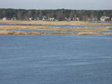 |
The restricted area protects the seashore meadows of the Lielupe River estuary, which are a very uncommon habitat in Latvia. The restricted area is on the left bank of the river, where one of the largest areas of wild swamp angelica is found. This is an important nesting area for birds. The territory is not improved for tourism, and it should be viewed from the Baltā (White) dune that is on the opposite bank of the Lielupe River. From there, the visitor will see a lovely landscape featuring the river estuary and the meadows which are around it.
|
|
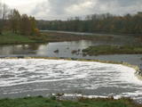 |
The recently renovated old brick bridge and the viewing area that is on the left bank of the Venta beyond the castle guard’s hut offers a lovely view of the widest and most impressive waterfall in Latvia – the Venta falls. It is worth visiting during the spring floods, when fish are migrating.
|
|
 |
This is one of the most impressive and extensive natural structures of its kind in Latvia in terms of appearance and landscape. The ice age left behind this wall-like terrain, which is up to 27 metres high and at the top of which the Rīga-Ērgļi road has been built. The Great Kangari hills offer a view of the Great Kangars lake and the Great Kangari swamps and ponds. The Ķoderi castle hill, also known as the “Big Man’s Bed” is found here. The restricted area was established to protect the structure and its related biotopes and plants.
|
|
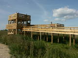 |
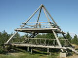
This is the only viewing platform in Latvia which is wheelchair-accessible. From the second level, you can see much of the restricted territory – areas of reeds, some wetlands, dunes and the estuary of the Daugava River. This is a good location for bird-watching.
|
|
 |
This structure is smaller than the Great Kangari hills – approximately 10 kilometres long and 16 metres high. This structure is near the Buļļi swamp, and the restricted area is meant to protect the structure, the swamp and the various forest types and rare plants that are in the area.
|
|
 |
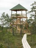
The wooden pathway which crosses the high swamp leads to the Teirumnīku swamp lake, which is right in the middle of the swamp. On the shores, there is a well-appointed place for leisure and relaxation. One can return to the starting point via a forest path. The trail is 800m long, and visitors will spend about an hour there. It is a part of the Tīrumnieki nature reserve.
|
|
 |
This is part of a hiking trail along the Cena bog. It is on the western side of the bog, at the centre of the 5-kilometre circular trail. You can see the vast swamp, as well as a military road that was installed during World War I and is marked by an “alley” of large pine trees. Alongside the tower is a fragment of the road that was installed more recently.
|
|
 |
A restricted area with a set of artificial ponds to the South-west of Saldus. The ponds attract many different kinds of birds during nesting and migration season. The location has not been improved for tourist purposes, but it is still an interesting place for some bird-watching. The forests around the ponds are also home to many protected birds and species of bat. |
|
 |
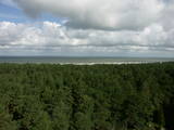
This is the only viewing platform of its kind. It is north of Pāvilosta, between the sea and Latvia’s largest gray dune. The second level of the platform offers a good view of the habitats which surround the dune, as well as the seashore and the largest seashore rock on the shores of the Baltic Sea – the Pāvilosta sea rock. You can also see the northern part of Pāvilosta. When it is windy outside, you’ll see kiteboard riders showing their tricks.
|
|
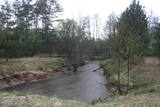 |
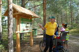
Nature restricted area is located to the South from former railroad Ventspils-Liepaja and includes approximately 6 km of Uzava River (and the old drainage system). The territory was used for agriculture during Soviet time, now it starts overgrow by scrubs. The protected nature values – rare bird species, including corncrakes, variety of grassland habitats and plant species. Territory is not useable for tourism activities. There is a possibility to get good insight into the North part of restricted area from the road Alsunga – Berzkalns where information stand is located.
|
|
 |
Augstā un purva vidusdaļā - pārejas tipa purvs, putniem nozīmīga vieta. Apmekļējumiem nav piemērota infrastruktūras trūkuma un sugu aizsardzības nolūkā. |
|
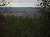 |
This is an area that is full of legend and tale. There is a stiff hillock, which stands about 66 metres above the surrounding land. From its southern side, you can see the Burtnieki lowlands. The tower, however, is not open to the public.
|
|
|
|
A diverse stand of forest that is bisected by the Vidzeme highway and the Rīga-Lugaži railroad line. This is a place where the largest endangered bird in the world – the European roller – can be found. Between one-quarter and one-fifth of the Latvian population of the crow is found here. This, too, is one of the last nesting places for the green woodpecker.
|
|
 |
38-метровая башня стены Овишского маяка (сигнальный фонарь расположен на высоте 33 метров) построена в 1814 году и без особых изменений функционирует до сегодняшнего дня. Это самый старый действующий маяк Латвии, в котором размещена экспозиция, посвященная Латвийским маякам. |
|


