
| No | Name | Description |
|---|---|---|
 |
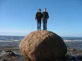
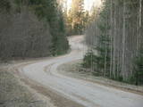
The Kaļķupe River valley was established as the Pilsupe River (formed by Kaļķupe River and Mazupe River) crossed the Blue hills of Šlītere to the South of Vīdale and Kaļķi. The distinct river valley has a branched network of gullies in which Devonian sandstone has been uncovered and can be seen in some locations. Puiškalns Hill (located at confluence of Kaļķupe River and Mazupe River), which was used as a castle hill and as a sacred location long in the past, is one of the most distinctive parts of the area. It is a popular tourist destination in the Talsi District. Hillside forests, various kinds of meadows and a wide range of plants are also of value in the local environment. |
|
 |
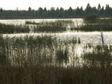
Periodically flooded flood-land meadows on the eastern and southern shores of Lake Burtnieks are an important nesting location for the rarely seen corncrake. A nature and information trail has been established at Vīsrags with directions, information stands and a viewing tower.
|
|
 |
The Staburags cliff of Rauna has been Latvia’s most distinct travertine cliff since the great Staburags cliff of the Daugava River sank under the waves during the construction of a hydroelectric power plant nearby. The cliff is approximately 8,000 years old and is still being formed as lime settles on moss and other plants. The Staburags cliff of Rauna is cited as the only location in Latvia of the Alpine butterwort, but it has not been seen there for the last 15 years. That is probably because of the many people who tramp across the cliff each year. The streams which deliver lime to the cliff are a biotope that is of priority at the EU level.
|
|
 |
Labi redzams no Kornetu centra. Līdz tornim var nokļūt pa taku, kas ved pāri pļavai uz uzlokas pa stāvā Dzērves kalna nogāzi. No torņa paveras viens no skaistākajiem Vidzemes un Latvijas skatiem. Redzams Dēliņkalns, blakus esošie Dzērves un Ievas ezeri, Hānjas augstiene un Lielais Munameģis (acīgākiem vērotājiem). |
|
 |
Dabas liegumā ietilpst divi aizauguši ezeri ar grūti pieejamiem krastiem - Lielais un Mazais Asūnes ezers, kas atrodas dienvidos no Asūnes ciema. Abus ezerus var vērot, atrodoties ārpus lieguma teritorijas - no blakus esošo pauguru augstākajām daļām, kas atrodas austrumos no abiem ezeriem. Ja līdzi būs paņemts tālskatis, iespējams, izdosies iztālēm novērot šeit esošās aizsargājamās putnu sugas, piemēram, melno zīriņu. |
|
 |
Covered with rocks and with small capes and inlets, this is the eastern shore of the Bay of Rīga and the only place in Latvia where sandstone outcrops are found. These are the result of the abrasive effects of waves between Tūja and Vitrupe. Among the most distinguished of these outcrops are the Veczemi cliffs, which are less than half a kilometre long and up to four metres high. The area has been improved for tourists. It has to be said that this part of the shoreline changes very often, particularly after large storms.
|
|
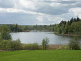 |
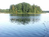
This restricted area protects the eutrophic Lake Istra and the biotopes that are alongside it – various kinds of forests and meadows. This is a particularly lovely part of the Latgale region. Interestingly, the so-called system of “rope farms” can still be seen in the nature park.
|
|
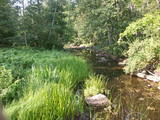 |
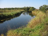
A distinct area of the lower reaches of the Vitrupe River, with small sandstone cliffs and many rare species of plants and molluscs. Visitors can visit the Ķirbiži Forest Museum and its information and botany trail. It weaves along both banks of the river and allows people to look at the most typical examples of flora in the region. The noble Vāloži oak tree is a key element there.
|
|
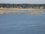 |
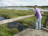
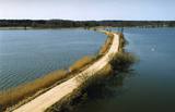
The restricted area protects the seashore meadows of the Lielupe River estuary, which are a very uncommon habitat in Latvia. The restricted area is on the left bank of the river, where one of the largest areas of wild swamp angelica is found. This is an important nesting area for birds. The territory is not improved for tourism, and it should be viewed from the Baltā (White) dune that is on the opposite bank of the Lielupe River. From there, the visitor will see a lovely landscape featuring the river estuary and the meadows which are around it.
|
|
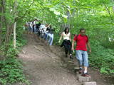 |
The Little Sigulda of Pilskalne is a place for longer or shorter hikes. Here you will find a number of trails – the Sprīdītis trail (1.6 km, featuring wooden sculptures of characters from fairy tales by Anna Brigadere), the Forest landscape educational trail (3.8 km), and the Highland landscape trail (8 km in each direction). The trails are in a sub-glacial depression with a number of little lakes and swamps that are connected by streams. This is a restricted environmental area aimed at protecting the landscape and its treasures. At the beginning of the trails (near Pilskalne) there is the Melnaiskalns (Rāmavas) castle hill, which is around 30 m high. |
|
 |
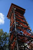
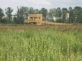
The tower is at the western end of the Seda swamp, accessed from the side of Jērcēni. Transport is limited here. The tower is in the area of the swamp where peat moss is extracted. It offers a broad view of the ponds of Seda and a boat rental facility that is nearby. It is an appropriate location for bird-watching during the season of migration. There is another bird-watching platform near the town of Seda. This is part of the ZBR. |
|
 |
Augstā un purva vidusdaļā - pārejas tipa purvs, putniem nozīmīga vieta. Apmekļējumiem nav piemērota infrastruktūras trūkuma un sugu aizsardzības nolūkā. |
|
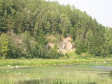 |
One of the most beautiful areas along the Venta River and its tributary, the Šķērvelis River. The river valleys and gullies along them are quite deep, and dolomite and sandstone cliffs can be spotted here and there. There are also rapids on the river. The largest cliffs in Kurzeme – the Ātraiskalns and Gobdziņi cliffs – can be seen on the banks of the Venta. The Lēni Catholic Church is near the restricted area. There are no tourist elements in the restricted territory at this time. The Venta is a popular destination for water tourists, however, from Nīgrande to Kuldīga. |
|
 |
This structure is smaller than the Great Kangari hills – approximately 10 kilometres long and 16 metres high. This structure is near the Buļļi swamp, and the restricted area is meant to protect the structure, the swamp and the various forest types and rare plants that are in the area.
|
|
 |
This restricted area protects Lake Jumurda, which is in the central part of the Vidzeme highlands, along with its three islands, the local broadleaf forests, and the surrounding landscapes.
|
|
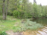 |
The most important aspect of the Sasaļi forest is the eutrophic Lake Sasalis, as well as the unusual Lake Melnezers. Also of importance are various types of forestland in the area. Lake Sasalis is a popular place for leisure and swimming.
|
|
 |
This territory is to the North of Skrunda, and it is an important location for water birds during their migration. Northern swans nest in the ponds, and sea eagles and other birds such as falcons and plovers use them for feeding. This is a good place for bird-watching, although it has not been particularly structured for that purpose. |
|
 |
Peat moss has been extracted from the Seda heath since the middle of the last century, but it is nevertheless one of the most important NATURA 2000 territories in Latvia, with a great diversity of landscapes, biotopes and biology – birds in particular. This is a good place for bird-watching during migration season, and viewing towers have been set up on the edge of the swamp for this purpose.
|
|
 |
This is one of the most interesting protected territories in the city of Rīga, and its aim is to protect coastline biotopes – dune and coastal meadows and the birds and plants which are found there (among them, 29% of the species of orchids). There is a marked information trail with a bird-watching tower. This is the only outdoor viewing tower in Latvia that has been adapted for the needs of people in wheelchairs.
|
|
 |
Palieņu un mitrās pļavas abos Dubnas upes krastos, kuras nelielā posmā var vērot no Rožupes - Vārkavas ceļa. Piemērotā laikā šeit dzirdēsiet griezes balsi, kas ir Eiropā izzūdoša putnu suga.
|
|


