
| Нo | Название | Описание |
|---|---|---|
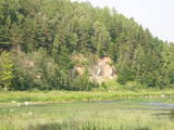 |
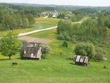
One of the most beautiful areas along the Venta River and its tributary, the Šķērvelis River. The river valleys and gullies along them are quite deep, and dolomite and sandstone cliffs can be spotted here and there. There are also rapids on the river. The largest cliffs in Kurzeme – the Ātraiskalns and Gobdziņi cliffs – can be seen on the banks of the Venta. The Lēni Catholic Church is near the restricted area. There are no tourist elements in the restricted territory at this time. The Venta is a popular destination for water tourists, however, from Nīgrande to Kuldīga. |
|
 |
This is a diverse territory in terms of biotopes and landscapes, and the restricted area was established to protect nesting and migrating birds in the area. One part of the swamp has a cranberry farm – one of the first artificially established farms of its type in Latvia.
|
|
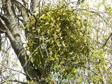 |
This is a mostly forested territory which is home to one of the largest areas of the white mistletoe, which is a semi-parasitic plant. It is best to observe this unique plant when it has no leaves. Latvia is the northern limit to the white mistletoe, which is why it is not all that common. It is interesting that even more of this rare specie can be seen outside of the nature restricted area. |
|
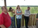 |
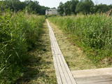
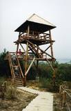
The tower is beyond the Oleri estate, in the small Oleri swamp, where at the end of a wooden footpath you can step upward a bit and learn about the landscape of a transitional swamp. This is part of the ZBR.
|
|
 |
One of the most distinct sub-glacial depressions in Latvia, with 11 lakes of various sizes and depths. This is a magnificently lovely territory, with particularly good views from the Drusku castle hill. On a clear day, one can even see the Hanja highlands of Estonia. The restricted territory was set up to protect boreal and hillside forests I the area.
|
|
 |
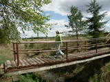
Near the Lielauce manor house start of a wooden pathway which crosses the transition-type swamp that is on the shore of Lake Lielauce to a boating facility near the open part of the lake. Boating and fishing are possible – here, too, the population of fish is regularly restored. The area is a part of the Vīķi swamp restricted zone. |
|
 |
The Staburags cliff of Rauna has been Latvia’s most distinct travertine cliff since the great Staburags cliff of the Daugava River sank under the waves during the construction of a hydroelectric power plant nearby. The cliff is approximately 8,000 years old and is still being formed as lime settles on moss and other plants. The Staburags cliff of Rauna is cited as the only location in Latvia of the Alpine butterwort, but it has not been seen there for the last 15 years. That is probably because of the many people who tramp across the cliff each year. The streams which deliver lime to the cliff are a biotope that is of priority at the EU level.
|
|
 |
The restricted area was set up to protect Nesaule Hill, which is a forested hillock in the area and features boreal and damp forests.
|
|
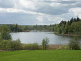 |
This restricted area protects the eutrophic Lake Istra and the biotopes that are alongside it – various kinds of forests and meadows. This is a particularly lovely part of the Latgale region. Interestingly, the so-called system of “rope farms” can still be seen in the nature park.
|
|
 |
This is a territory which regularly floods when the Lielupe River crosses its banks. These are flood-land meadows of importance to birds. The area can be surveyed from the Rīga-Liepāja highway and the Kalnciems road which runs along it. |
|
 |
Relatīvi grūti pieejama un cilvēka mazskarta teritorija kūdrā izstrādātajā Cenas tīreļa ziemeļaustrumu daļā, kur saglabājušies augstā purva biotopi ar purva ezeriem, kas kopumā veido nozīmīgu vietu ligzdojošām un migrējošām zosveidīgo, tārtiņveidīgo u.c. putnu sugām. Teritorija nav piemērota (un nav vēlams) tūrisma aktivitātēm.
|
|
 |
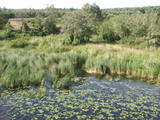
There is a small and relatively hard to reach area on the western shore of Lake Būšnieks which has been restricted to protect swamp habitats and several protected plants. Boat base is on the northern shore of the lake offers boat rental. From the plank-way good sites of eutrophic part of Lake Būšnieks can be seen. A well-appointed recreational facility (not included in the restricted area) is on the opposite shore of the lake. |
|
 |
Līčiem, pussalām un salām bagāts ezers ar izrobotu krasta līniju, kas savienots ar Zvejnieku un tālāk - citiem Latgales augstienes ezeriem. Ozolu un platlapju meži, kas aug uz ezera salām un pussalās ir ne tikai aizsargājami, bet arī Latvijas mērogā nozīmīgi biotopi. Tiesa, to vērtību apzināsies tikai vides speciālisti. No Jašas ezera var uzsākt laivu braucienu pa vienu no Latgales ezeru "kēdēm". Ezera austrumu krastā atrodas Geļenovas parks.
|
|
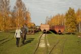 |
Sedas purva kājnieku maršruts atrodas dabas liegumā Sedas purvs, pārgājienu pa maršrutu iespējams apvienot ar Sedas pilsētas apskati, kas ir unikāls 20.gs. 50.–60. gadu pilsētbūvniecības un arhitektūras paraugs - kūdras purva strādnieku pilsēta. Maršrutam ir divi apļi - Jērcēnu aplis - 5,5 km un Sedas aplis - 4,2 km. Tajos apakatāms izstrādātais kūdras purvs, šaursliežu dzelzceļš, ritošais sastāvs, divi skatu toņi. Rudenī un pavasarī - putnu migrācijas lāikā - interesanta vieta putnu vērošanai. GPS koordinātes: Jērcēnu puses aplim: 57.7055987, 25.7001324; Sedas puses aplim: 57.6699587, 25.7514815. |
|
 |
Salīdzinoši liela un cilvēka mazskarta teritorija ziemeļos no Lubāna ezera, kas izceļas ar lielu purvu un mitro mežu, kā arī tajā dzīvojošo organismu daudzveidību. Cauri teritorijas austrumu daļai tek Aiviekste. Dabas liegums ir grūti pieejams, tajā nav izveidota ar tūrismu saistīta infrastruktūra, tādēl vislabākais veids ir to aplūkot no Lubānas - Gaigalavas ceļa, kā arī putnu vērošanas torņa pie Gomeļa ezera (Gūmelis), kurš gan 2007. g. rudenī bija cietis no apmeklētāju vandālisma. Teritorija ietilpst Lubāna mitrāja kompleksā.
|
|
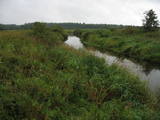 |
Palieņu pļavas starp Rūjienu un Rūjas ieteku Burtnieku ezerā, kurām raksturīga liela augu un putnu sugu daudzveidība. Tās robežojas ar bijušiem Rūjas zivju dīķiem, kas šobrīd aizaug ar mežu. Rūjas palienes var vērot gan braucot ar laivu pa Rūju, gan arī no ceļa, kas ved uz minētajiem dīķiem. Tur izvietots informācijas stends.
|
|
 |
38-метровая башня стены Овишского маяка (сигнальный фонарь расположен на высоте 33 метров) построена в 1814 году и без особых изменений функционирует до сегодняшнего дня. Это самый старый действующий маяк Латвии, в котором размещена экспозиция, посвященная Латвийским маякам. |
|
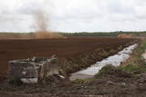 |
Nature restricted area is established to protect various wetland habitats – Big Kirba Bog and protected plant species within it. Only the West part of the Bog is a protected nature area. The rest of the bog is used mainly for intensive extraction of peat and large cranberry cultivation. Nature restricted area of the bog has no tourism infrastructure therefore is not useable for tourist visits.
|
|
 |
A small and forested territory with sulphurous springs, among which the most popular one is the Ellīte sulphur spring. It has sulphurous water with a low level of minerals, and the water supposedly has medicinal properties. The area around the stream is well-appointed, and a pathway leads to it. The stream is considered to be the source of the Iecava River. The restricted area is there to protect biotopes and protected plants which are in the area.
|
|
 |
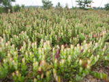
Similar as Alsungas mezi (Alsunga forests) – is not intended and appropriate for visits. A narrow path of the restricted area can be seen from the gravel road – Saka-Apriki. Nature restricted area established mainly for protection of Erica tetralix (often called "cross-leaved heath") and it is one of the most important growing places.
|
|


