
| Нo | Название | Описание |
|---|---|---|
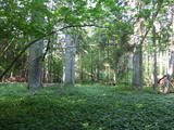 |
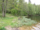
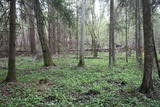
The Ukri forest on the border of the Dobele district is what is known as a vast forest. It has oak trees (including many huge ones), linden trees, oak trees (large stands of oak are uncommon in Latvia), and other deciduous trees. A small area of the forest can be toured in the company of a guide to look at the animals of the area and their importance in the flow of nature. The restricted area protects forest habitats, plants and animals, including many that are typical of the southern areas of Latvia. |
|
 |
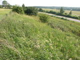
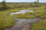
One of few places in Latvia (around 1 km to the North from Lapmezciems) where used to be beautiful juniper meadows. Since no agriculture activity (grass cutting, cattle grazing) has been implemented in the area, juniper meadows are overgrowing and disappearing. To save the area sustainable management is needed. Slitere National Park with Blue Mountain cliff and Slitere lighthouse is located in short distance from Kadiku nora (Juniper meadow).
|
|
 |
A diverse stand of forest that is bisected by the Vidzeme highway and the Rīga-Lugaži railroad line. This is a place where the largest endangered bird in the world – the European roller – can be found. Between one-quarter and one-fifth of the Latvian population of the crow is found here. This, too, is one of the last nesting places for the green woodpecker.
|
|
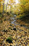 |
The lime gully that emerged as the Baltic ice lake receded is crossed by the powerful streams of Mežmuiža, and the water from these streams contains a high concentration of lime salts. The water from the streams flows into a mill pond that has a very interesting colour. The sculptor Teodors Zaļkalns once lived in the travertine mill that is alongside the pond. Wood pathways have been installed for those who wish to visit the streams.
|
|
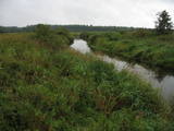 |
Palieņu pļavas starp Rūjienu un Rūjas ieteku Burtnieku ezerā, kurām raksturīga liela augu un putnu sugu daudzveidība. Tās robežojas ar bijušiem Rūjas zivju dīķiem, kas šobrīd aizaug ar mežu. Rūjas palienes var vērot gan braucot ar laivu pa Rūju, gan arī no ceļa, kas ved uz minētajiem dīķiem. Tur izvietots informācijas stends.
|
|
 |
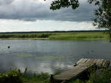
The most important aspect of the Sasaļi forest is the eutrophic Lake Sasalis, as well as the unusual Lake Melnezers. Also of importance are various types of forestland in the area. Lake Sasalis is a popular place for leisure and swimming.
|
|
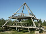 |
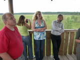
This is the only viewing platform of its kind. It is north of Pāvilosta, between the sea and Latvia’s largest gray dune. The second level of the platform offers a good view of the habitats which surround the dune, as well as the seashore and the largest seashore rock on the shores of the Baltic Sea – the Pāvilosta sea rock. You can also see the northern part of Pāvilosta. When it is windy outside, you’ll see kiteboard riders showing their tricks.
|
|
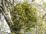 |
This is a mostly forested territory which is home to one of the largest areas of the white mistletoe, which is a semi-parasitic plant. It is best to observe this unique plant when it has no leaves. Latvia is the northern limit to the white mistletoe, which is why it is not all that common. It is interesting that even more of this rare specie can be seen outside of the nature restricted area. |
|
 |
This swampy territory used to be part of a Littorena Sea lagoon, and it is a place where many rare and protected birds such as woodpeckers live and nest. Territory is hard to reach although some of the territory can be surveyed from the Tukums-Kolka road. Wet meadows is called "lankas" in Kurzeme region. |
|
 |
The tower is beyond the Oleri estate, in the small Oleri swamp, where at the end of a wooden footpath you can step upward a bit and learn about the landscape of a transitional swamp. This is part of the ZBR.
|
|
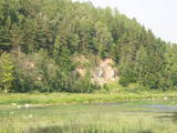 |
One of the most beautiful areas along the Venta River and its tributary, the Šķērvelis River. The river valleys and gullies along them are quite deep, and dolomite and sandstone cliffs can be spotted here and there. There are also rapids on the river. The largest cliffs in Kurzeme – the Ātraiskalns and Gobdziņi cliffs – can be seen on the banks of the Venta. The Lēni Catholic Church is near the restricted area. There are no tourist elements in the restricted territory at this time. The Venta is a popular destination for water tourists, however, from Nīgrande to Kuldīga. |
|
 |
This is a large set of coastal meadows, ancient rivers and areas of reeds. It is found at a location where the Daugava River used to flow – between Vecmīlgrāvis and Vecāķi. There are inland dune meadows here, complete with the very rare silver grass. Vecdaugava is an important location for nesting birds and several uncommon plant species. On the southern end of the Vecdaugava peninsula, at a place called Skanstnieki, one can find remnants of medieval Swedish fortifications. The Vecdaugava Regional Research and Fishing Museum is here, as well.
|
|
 |
There is picnic area and information stand at the end of the forest path leading from Muiznieki to Klanu Bog. Klanu Lake was formed in the place of Littorina marine lagoon. Nature restricted area was established to protect biotopes in the area of Klanu, Dziru and Stavu Lakes. There is wide information about the area available on the information stand.
|
|
 |
This territory protects the shore of the onetime Baltic lake of ice, which most significant part stretches for 10 kilometres on the eastern side of the Grobiņa-Ventspils highway from Kapsēde till Vērgale bus stop. From the top of this ancient shoreline there is a lovely view of the Piejūra lowlands, but no specific viewing areas or information stands have been installed. There are protected species and habitats in the territory. |
|
 |
Augstā un purva vidusdaļā - pārejas tipa purvs, putniem nozīmīga vieta. Apmekļējumiem nav piemērota infrastruktūras trūkuma un sugu aizsardzības nolūkā. |
|
 |
One of the rare places (see also Rucavas ivju audze) in Latvia where two rare and protected wild tree species grow - yew-tree and Baltic ivy. Territory is not marked on site with information signs or stands therefore it is hard for visitors to find. Not usable as tourism object.
|
|
 |
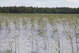
Along with the Nagļu ponds, these are Latvia’s largest fishing ponds. They were established on the flood-land peat areas of Lake Lubāns in the 1970s, when the hydrotechnical system of the lake was first established. The Lubāna-Gaigalava road bisects the Kvāpāni-Īdeņa ponds. There are three bird-watching towers on the dams of the ponds. The ponds are a major location for water bird nests, as well as places for migrating birds to rest. There are extensive bird-watching opportunities in the area.
|
|
|
|
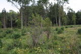
The restricted area was set up to protect Nesaule Hill, which is a forested hillock in the area and features boreal and damp forests.
|
|
 |
Very wide territory for a nature restricted area where extensive forests and several bogs can be found. The territory is important living space for many bird species. Vasenieku bog path with observation tower is the most attractive sites of the restricted area and offers unique landscape of the bog for its visitors. Waterproof shoes are recommended for visitors as the first 500 m of the path is molded turf rampart. Information stands are significant source of information along the path. It is suggested to visit also Stikli (Glass) village where glass factory used to be. Chandelier of Stende church has been made in this factory (by memory of Inese Roze).
|
|
 |
This territory covers the shoreline between the Ventspils-Liepāja highway and the Baltic Sea on both sides of the Užava River. The territory was established to protect shoreline biotopes such as the grey dunes, as well as a number of endangered plants. To the South of the mouth of the Užava River we find one of the most romantic lighthouses in Latvia – the Užava lighthouse, which is at the top of a steep dune. |
|


