
| Нo | Название | Описание |
|---|---|---|
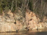 |
Boaters along the Gauja will see the Velnala cliffs, which are the last mighty wall along the banks of the Gauja River valley – approximately 15 m high. From the opposite shore of the river, where there are leisure facilities, once can spot the Krimulda Devil’s cave, which is in the centre of the cliff, is some 19 m deep, and is 4.7 m high. There were once wooden structures which allowed people to visit the cave, but that stopped in 1980 for safety reasons. If you head toward Turaida along the lower part of the basic Gauja River shoreline from the Velnala cliffs, then, particularly when the trees are bare, you will see the mighty sandstone Piķene cliff. At its foot is the Piķene beaver trail, which is approximately 1 km long. On quiet evenings, you may well spot a beaver at work. Along the path you will see the Small Devil’s cave (5 m deep) with the Wisdom Stream that flows out of it. The Aunapiere cave is almost as deep. Between the cliff and the Gauja are several small rivulets which are of enormous importance in preserving the diversity of the surrounding environment. |
|
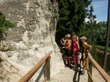 |
In terms of shape, this is one of the most diverse areas of uncovered sandstone in Latvia. Found on the right bank of the Gauja river, the Sietiņiezis is up to 15m high. Small holes that can be seen in the cliff face are created by single and protected insects, which carve tiny caves in the cliff for their caterpillars. A circular and well appointed trail, with stairs, has been installed. It is 1.5 km in length and will take an hour or so to traverse. Objects are in the Gauja National Park.
|
|
 |
This trail offers education about the forest for children of all ages, families with children, and friends of the environment. The trail is located in the Īle Parish of the Auce Administrative District, 2 km from the Pokaiņu forest. |
|
 |
Болото Бажу – самое большое болото в Слитерском национальном парке –
зона строгого режима, нахождение в которой запрещено.
|
|
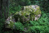 |
Līdz akmenim aizved (ir norādes) skaista taka, kas līkumo pa Rogāļu strauta izrauto gravu. Strauta kreisā krasta nogāzē, ~ 0,1 km pirms tā ietekas Daugavā, iegūlis 6,5 m garais, 4,6 m platais un līdz 3,7 m augstais Rogāļu akmens, kura tilpums ir novērtēts ap 40 m³. Blakus tam atrodas liela atlūza. |
|
 |
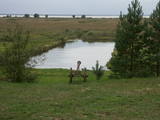
This is one of the most impressive and extensive natural structures of its kind in Latvia in terms of appearance and landscape. The ice age left behind this wall-like terrain, which is up to 27 metres high and at the top of which the Rīga-Ērgļi road has been built. The Great Kangari hills offer a view of the Great Kangars lake and the Great Kangari swamps and ponds. The Ķoderi castle hill, also known as the “Big Man’s Bed” is found here. The restricted area was established to protect the structure and its related biotopes and plants.
|
|
 |
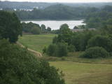
The main goal of the Vestiena protected landscape area is to protect the landscape values in the Vidzeme highlands. The protected area is in the middle of the Vidzeme highlands with the highest and most prominent relief, including Gaiziņkalns, the highest spot in the country. The many lakes found in the area - Viešūrs, Talejas, Kāls, Pulgosnis and others – not only add to the variety of the landscape, but also offer tourism and recreation options. The Vestiena protected landscape area encloses several other especially protected/Natura2000 sites – the Gaiziņkalna nature park, the island of the lake Kāla, the lake Ilziņa restricted natural area. Among the most interesting tourist attractions are the Vestiena estate, the Piekūnu wandering trails, the Gaiziņkalna nature trail. The area is rich in landscapes, however, there are no viewing spots or towers installed to observe the landscape. On the top of the Gaiziņkalns, the Latvia’s highest spot, there still stands the wreck of the former viewing tower.
|
|
 |
В пейзажном стиле парк был создан во второй половине 18-го века и начале 19-го века. Инициатором создания парка был владелец Алуксненского имения барон Отто Герман фон Фитингоф. В обширном пейзажном парке можно осмотреть значимые малые архитектурные формы – павильон Александра, храм древнегреческого бога ветров Эола, Пальмовый дом, гранитный обелиск О. Г. фон Фитингофу, установленный в 1799-м году, мавзолей рода баронов, бассейн фонтана, сделанный из одного гранитного куска и гранитные скамейки. Алуксненский дворцовый парк считается одним из красивейших парков в Видземе. |
|
 |
Известное еще со времен Курземского герцогства как самое северное место, где выращивали и делали кисловатое вино герцогства. С 1999 г. ежегодно, во второй половине июля, в Сабиле проходит Праздник вина. С Винной горы приоткрывается прекрасный вид на провинциальный город, который расположился на берегах древней долины Абавы. |
|
 |
Along with the Nagļu ponds, these are Latvia’s largest fishing ponds. They were established on the flood-land peat areas of Lake Lubāns in the 1970s, when the hydrotechnical system of the lake was first established. The Lubāna-Gaigalava road bisects the Kvāpāni-Īdeņa ponds. There are three bird-watching towers on the dams of the ponds. The ponds are a major location for water bird nests, as well as places for migrating birds to rest. There are extensive bird-watching opportunities in the area.
|
|
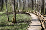 |
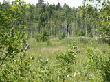
The excessively damp forests at this place include the Vēršupīte River bog, and this is one of the most diverse biotopes in Latvia in terms of the number of species that can be found here. The fact that the area is regularly flooded is shown by the fat roots of black alders – indeed, the place looks like a stand of mangroves. The wooden pathway that is the Dumbrāju trail starts at the Forest House for those who wish to examine the bog. The most impressive views are seen during spring floods or rainy seasons at other times of the year. The little river breaks out of its bed and floods a large territory. The Lake Sloka hiking trail is another place where you can study the Vēršupīte bog. The circular trail is 3 km long, and its beginning is at the Lake Sloka bird watching tower. |
|
 |
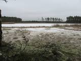
Relatīvi grūti pieejama un cilvēka mazskarta teritorija kūdrā izstrādātajā Cenas tīreļa ziemeļaustrumu daļā, kur saglabājušies augstā purva biotopi ar purva ezeriem, kas kopumā veido nozīmīgu vietu ligzdojošām un migrējošām zosveidīgo, tārtiņveidīgo u.c. putnu sugām. Teritorija nav piemērota (un nav vēlams) tūrisma aktivitātēm.
|
|
 |
Самый молодой национальный парк Латвии (2007 г.) находится в „Крае голубых озер” – в Латгальском крае. Одной из задач создания парка было сохранение самого полноводного Латвийского озера - Разнас, самого богатого островами озера – Эжезерс, и других водоемов, а также сохранение характерного для Латгалии холмистого пейзажа и культурно-исторической среды. В настоящее время одним из самых популярных объектов национального парка является Маконькалнс с прекрасным видом на озеро Разнас. В настоящее время в этом сравнительно молодом парке пока только планируется и производится его туристическое благоустройство - создание троп, маршрутов и т.д., поэтому желательно посещать уже законченные объекты. |
|
 |
This is an uncommon landscape for the Kurzeme region with a protected biotope – open inland dunes with meadows of silver grass and forests of deciduous trees, including the common hornbeam. Tourists can visit the Muiža (Lejas) sacred stream on the right bank of the Sventāja valley, above which they will find Latvia’s most noble bird-cherry trees. A nice reed pergola has been installed above the stream. Wide are of Sventāja River valley can be overseen from the road before the stream. |
|
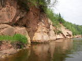 |
Eine der malerischen Sandsteinaufschüssen in Lettland. Die Länge beträgt ung. 500 m, die Höhe – 43 m. Gegenüber befindet sich die Ķūķu-Schnelle. |
|
 |
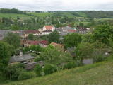
We recommend that you walk through the town of Kandava not only to enjoy the charm of a small town, but also to find fantastic viewing locations where you can see the town and the shores of the ancient Abava River valley from the Kurši (Ancestor) castle hill, Lielā Street, the Bruņinieki castle hill and Zīļu Street (School Hill), as well as from the area of the Ozolāji open-air stage.
|
|
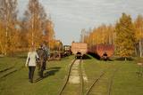 |
Sedas purva kājnieku maršruts atrodas dabas liegumā Sedas purvs, pārgājienu pa maršrutu iespējams apvienot ar Sedas pilsētas apskati, kas ir unikāls 20.gs. 50.–60. gadu pilsētbūvniecības un arhitektūras paraugs - kūdras purva strādnieku pilsēta. Maršrutam ir divi apļi - Jērcēnu aplis - 5,5 km un Sedas aplis - 4,2 km. Tajos apakatāms izstrādātais kūdras purvs, šaursliežu dzelzceļš, ritošais sastāvs, divi skatu toņi. Rudenī un pavasarī - putnu migrācijas lāikā - interesanta vieta putnu vērošanai. GPS koordinātes: Jērcēnu puses aplim: 57.7055987, 25.7001324; Sedas puses aplim: 57.6699587, 25.7514815. |
|
 |
This swampy territory used to be part of a Littorena Sea lagoon, and it is a place where many rare and protected birds such as woodpeckers live and nest. Territory is hard to reach although some of the territory can be surveyed from the Tukums-Kolka road. Wet meadows is called "lankas" in Kurzeme region. |
|
 |
The tower is beyond the Oleri estate, in the small Oleri swamp, where at the end of a wooden footpath you can step upward a bit and learn about the landscape of a transitional swamp. This is part of the ZBR.
|
|
 |
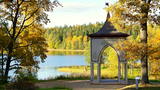
This park is located along the shores of the Tērvete River Valley. It is a vast forested area which has been adapted successfully for travellers. In 2004, it was nominated as the most family - friendly destination in the land. There is a web of trails for one-day hikes. Viewing tower on the shore of the Tērvete River, views also from the Tērvete castle hill and Zviedru (Swedish) Hill.
|
|


