
| Нo | Название | Описание |
|---|---|---|
 |
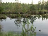
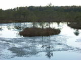
This wooden pathway will introduce the visitor to a high-type swamp and a unique habitat – a place where sulphur streams flow into the Raganu swamp. The little lakes in the swamp are unique – they are the result of sulphur bacteria, and there is a special range of species in those lakes. The landscape is interesting, and the smell of sulphur pervades, mostly from sulphur ponds. The trail is 800m long and will require 20 minutes to an hour to traverse. The object is on the border of the Zemgale and Vidzeme regions.
|
|
 |
This territory is around 9 square kilometres in size and is found to the North of the village of Kūdra, where the so-called old peat quarries are found. Peat was extracted here during the first period of Latvian independence. Today the territory is overgrown, preserving the old and flooded quarries which offer a very unusual landscape. The best way to examine them is on foot or bike, taking the road from the Kūdra railroad station which leads to Lake Sloka. |
|
 |
Taka atrodas Riekstusalas pussalā, netālu no putnu vērošanas torņa. Uz peldošiem pontoniem celtā laipa iepazīstina ar Kaņiera ezeru „tuvplānā”. Var iepazīt niedrājus, to putnus, labi redzamo ezera gultni ar zivju mazuļiem un kalcifilām augu sabiedrībām. Laipa aizved līdz salai, uz kuras aug kadiķi. |
|
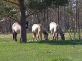 |
Für den Zweck der Bewirtschaftung der Niederungsauen des Pape-Sees und der Vermehrung der biologischen Vielfalt sind hier Konik-Wildpferde angesiedelt wurden. Die kann man mit einem örtlichen Guide kennenlernen. |
|
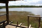 |
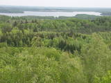
This is on the north-western shore of Lake Lielezers of Limbaži, at the start of the Lielezers nature trail. The tower opens up a view of the lake and its lovely shores. It is worth walking the trail, which is several kilometres long, because it is an interesting one. This is part of the ZBR. |
|
 |
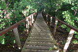
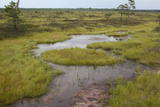
Познать уникальную природу заповедникaТейчи можно, отправившись на экскурсию под руководством гида по тропе Силду, которая была реновирована в 2013 году. Маршрут протяженностью примерно в 3 км пролегает по удобным деревянным мосткам. Вам откроется удивительный вид на нетронутый болотный ландшафт. Вы ознакомитесь с разными типами болота (верховые моховые, переходные и травяные), сможете увидеть окнища и мочажины с прочного основания мостков, а также посмотреться в зеркала двух болотных озер (Силду и Дзервитес) и посетить болотный остров Сиксала (Siksala). Тропу можно посетить только с сопровождением сотрудника Агентства по охранe природы с 1 июня по 31 октября. |
|
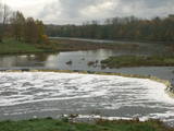 |
The recently renovated old brick bridge and the viewing area that is on the left bank of the Venta beyond the castle guard’s hut offers a lovely view of the widest and most impressive waterfall in Latvia – the Venta falls. It is worth visiting during the spring floods, when fish are migrating.
|
|
 |
This is another so-called hill left behind by the Ice Age – five kilometres long with a height of between 15 and 30 metres and with high hillocks and steep hillsides. Te most distinct part of the hill can be found between Lake Pinti and Lake Šeški. The pine forests on the hillocks are a habitat with many rare and protected species. A trail has been established to tour Grebļa Hill, as well as Āža Hill and Kausu Hill, but it is recommended that visitors travel the trail in the company of a guide. The biological diversity of the area is made clear if one knows, for instance, that more than 500 kinds of butterflies have been found in the restricted territory.
|
|
 |
Круговая тропа длиной 1,2 км рядом с маяком Шлитере ведет вниз с Голубых гор или древнего берега Балтийского ледового озера и продолжается вдоль лесов и болот прилегающей равнины. |
|
 |
The mouth of the most beautiful river of Vidzeme. On the seashore between the mouths of River Gauja and River Daugava, one of the largest dune ranges in Latvia with distinctive parabolic dunes overgrown with forest (wooded dunes) is situated. The Mouth of River Gauja is unique as it is one of the few major rivers in Latvia and in EU countries to flow into the sea naturally. There is no harbour or other hydro-engineering construction. It is a popular recreation area in the vicinity of Riga and Saulkrasti while, unfortunately, the lack of infrastructure makes it suffer from anthropogenic load. Not far from the rivermouth, hidden in dunes, there are pillboxes which were built in 1920 or 30ies as anti-airborne barriers. There was a whole range of them along the coastline from the mouth of the River Lielupe to the mouth of the River Gauja forming a part of the Daugavgrīva Fortress fortifications. The pillbox is made of concrete, ca 1.5m thick. Every year, on the 3rd Sunday in August, a lamprey festival takes place in Carnikava town by the Gauja rivermouth. Carnikava is called the Lamprey Capital as it is famous for its lamprey fishing tradition and generous catches. The Mouth of the River Gauja is a good bird-watching area, especially in spring and autumn when one can observe the highest variety of species. Just few of the many bird species that can be observed near the Gauja rivermouth |
|
 |
One of few places in Latvia (around 1 km to the North from Lapmezciems) where used to be beautiful juniper meadows. Since no agriculture activity (grass cutting, cattle grazing) has been implemented in the area, juniper meadows are overgrowing and disappearing. To save the area sustainable management is needed. Slitere National Park with Blue Mountain cliff and Slitere lighthouse is located in short distance from Kadiku nora (Juniper meadow).
|
|
 |
The Grey Dune of Pāvilosta nature reserve covers 42 hectares of land and has been designated to protect Latvia’s widest dune (1.5 km parallel the seacoast, and 812m in the direction from the sea to inland) and the biotopes and species found there. A two-storied watching platform is built to savour the scenery. In Soviet time, local fishermen used to dry seaweed in dunes for production of agar, and thus rich vegetation developed in the dune. The Gray Dune is part of a unique landscape with the sea view, the traditional architecture of Pāvilosta fishing town, and biotopes, including protected, which border the nature reserve: pine forest, embryonic dunes, white dunes, and wet beech where once can find springs. Biotope 2130, “Fixed dunes with herbaceous vegetation (grey dunes)” is found here. At present, pines are taking over the biotope, therefore some maintenance activities are required. The Grey Dune is most beautiful in the second half of July and in August when the blossoming Breckland Thyme (Thymus serpyllum) and Narrowleaf Hawkweed (Hieracium umbellatum) colour the dune in shades of yellow and violet. The most typical species here are Pasqueflower (Pulsatilla pretense), Grey Hair-grass(Corynephorus canescens), Blue Hair Grass (Koeleria glauca), Sand Pink (Dianthus arenarius). The Gray Dune earned wide recognition when a group of enthusiasts actively campaigned for six years to achieve the status of the nature reserve. Guna Grimsta, a group representative remembers that they organised events and activities throughout Latvia involving large part of the society, prominent personalities, church parishes, NGOs, school youth and university students. The activists were writing letters, making videos, doing research articles, composing music, collecting signatures and submitting proposals to achieve official status of the Grey Dune as an especially protected nature site. They organised seminars, concerts, art plenaires and exhibitions, educational excursions, joint-work, musical church services, meetings with high officials and their on-site visits to the Gray Dune. In 2006 the group received the title „Proudness of Latvia” awarded by the national TV3 broadcasting company and daily paper „Diena”. |
|
 |
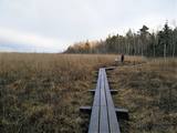
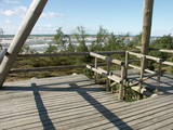
Very wide territory for a nature restricted area where extensive forests and several bogs can be found. The territory is important living space for many bird species. Vasenieku bog path with observation tower is the most attractive sites of the restricted area and offers unique landscape of the bog for its visitors. Waterproof shoes are recommended for visitors as the first 500 m of the path is molded turf rampart. Information stands are significant source of information along the path. It is suggested to visit also Stikli (Glass) village where glass factory used to be. Chandelier of Stende church has been made in this factory (by memory of Inese Roze).
|
|
 |
Старейший дендрарий Латвии (основан в 1891 г.), посадки которого спланировал и сформировал владелец Скриверской господской усадьбы Максимилиан фон Сиверс (1857 – 1919 гг.). Сейчас в парке насчитывается примерно 300 видов и сортов растений. Насаждения сгруппированы по месту их естественного роста - для различных мировых геоботанических районов. Для удобства посетителей проложены дорожки, а рядом с растениями находятся дощечки с названиями. Фонтан работает со вторника по воскресенье. На другой стороне шоссе Рига – Даугавпилс (А6) находится Скриверский лесной парк с прогулочными тропами. |
|
 |
This territory is meant to protect the large hillocks and lakes of the Augšzeme highlands – Lake Svente, Lake Medums, Lake Ilga and others, with their islands, landscapes and species. The nature park which has been established around Lake Svente and Lake Medums is part of this territory, and there are several areas that are restricted for environmental reasons – Lake Bardinskis, Lake Skujine, and the islands of Lake Medums and Lake Svente. There is a viewing tower on Egļukalns Hill, along with downhill ski routes. |
|
 |
Construction on the lighthouse was initially completed in 1879. The structure suffered damage during both world wars and was restored several times. The structure is 19 metres high and stands 46.5 metres above the wavy sea. Here you will find one of the loveliest views of the shores of the Baltic Sea.
|
|
 |
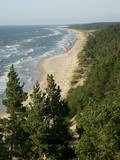
The trail climbs up and down along the bluffs of lower River Pilsupe and reveals a fascinating sight of three white dune exposures (the largest is called the White Dune). The dune range has formed in the period of the Littorina Sea several thousands of years ago. The time required to walk the trail is ~0.3 h. Evidence of Stone Age settlements have been found in the vicinity. |
|
 |
One of the few places in Latvia where there are so many well-organised pathways. The region is known for castle hills, the location where the great Latvian author Anna Brigadere (1861-1933) lived and worked, the storybook character figures that are scattered around that area, a great forest, an arboretum, a museum of history, a viewing tower, landscapes, etc. This has been recognised as the most family-friendly place in the country.
|
|
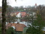 |
The town of Talsi is known as the “town of the nine hillocks,” and it is worth touring the location on foot. You’ll find the best views from the Talsi castle hill (views of Lake Talsi and Ķēniņkalns Hill), Sauleskalns (Lake Talsi, the castle hill, Ķēniņkalns Hill), and the hiking trails of Ķēniņkalns (Lake Talsi, the castle hill, the historical town centre).
|
|
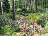 |
Проект по развитию дендрария начался в 1996 году, когда дендрологи Саласпилсского ботанического сада Раймондс Циновскис, Инара Бондаре и представители самоуправления Руцавы договорились о создании экспериментальных посадок на холме усадьбы Руцава. Посадка насаждений была начата в 1998 году. В дальнейшем, посадка растений проводилась также в центре Руцавы и у начальной школы. Посадки ежегодно пополняются новыми и экзотическими экземплярами растений со всего мира. Праздник сада традиционно проводится в мае, во время цветения рододендронов и магнолий. |
|


