
| Нo | Название | Описание |
|---|---|---|
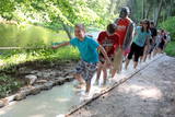 |
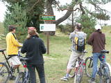
The first barefoot trail created in the Baltic States in the recreation complex "Valguma pasaule", which is located on the forested shores of Lake Valguma. When walking on the path, the feet "massage" sand, wood chips, clay, peat, gravel, cones and various other materials. |
|
 |
This tree is the one in Latvia and perhaps the Baltic States that has the densest foliage. Its crown measures 33 x 31 metres.
|
|
 |
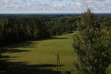
This is a view worth a journey from a distance. This is an impressive terrain for Latvia, and here you will see as far as the Hanja highlands of Estonia, where the Great Munameģis Hill – the highest surface in the Baltic States – can be found.
|
|
 |
This is one of the most impressive and extensive natural structures of its kind in Latvia in terms of appearance and landscape. The ice age left behind this wall-like terrain, which is up to 27 metres high and at the top of which the Rīga-Ērgļi road has been built. The Great Kangari hills offer a view of the Great Kangars lake and the Great Kangari swamps and ponds. The Ķoderi castle hill, also known as the “Big Man’s Bed” is found here. The restricted area was established to protect the structure and its related biotopes and plants.
|
|
 |
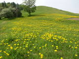
These meadows are of distinction because of the curvy Slampe River, which has caused a gradual recovery of damp meadows, complete with species of plants and animals that are typical of such areas. Domestic animals adapted for life in the wild can be seen here, and a bird watching tower on the location will offer you an excellent opportunity to view them. You can get to the meadows via a narrow corridor known as the Melnragu throat. The gravel road will lead to a hillock called Kurgāns from which you can have an excellent view of the surrounding landscape. |
|
|
|
Atrodas pie Jēkabpils – Rēzeknes autoceļa (A 12), - autostāvlaukuma malā. No torņa redzama samērā plaša Teiču purva daļa ar atsevišķām salām (kokiem apauguši paaugstinājumi) augstā purva ainavā. Teiču purvam ir dabas rezervāta statuss, tādēļ apmeklējams ir tikai tornis. |
|
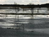 |
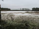
This is an open territory which is 3.5 km long and 2 km wide. It is located on the left bank of the Lielupe River between the village of Pavasari and the Odiņi homestead. The polder was established during the Soviet era to obtain farmland, and back then it was used very intensively. Today, it is slowly becoming overgrown, and despite this, this is one of the most important locations in Europe for corn-crakes. A gravel road crosses the polder from the North to the South, and this is an excellent place to hear the songs of the corn-crake. |
|
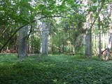 |
The Ukri forest on the border of the Dobele district is what is known as a vast forest. It has oak trees (including many huge ones), linden trees, oak trees (large stands of oak are uncommon in Latvia), and other deciduous trees. A small area of the forest can be toured in the company of a guide to look at the animals of the area and their importance in the flow of nature. The restricted area protects forest habitats, plants and animals, including many that are typical of the southern areas of Latvia. |
|
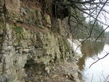 |
This is a unique geological object of paleontological importance. Up to four metres high, the cliff has yielded up fossils of ancient invertebrates and fish.
|
|
 |
The most important aspects of this park are a shallow lagoon-type lake – Lake Pape, with its flood land meadows, the shore of the Baltic Sea, the Nida swamp, and the more than 270 different types of birds that have been spotted here. The oldest bird ringing station in Latvia (est. 1966) is found between Lake Pape and the Baltic Sea. Birds and bats are caught and ringed there. Lake Pape is the first place in Latvia where so-called “wild” horses (the “Konik” breed) were released with the aim of managing the flood land meadows.
|
|
 |
This is a route for hikers and bicyclists, starting at the village of Vaidava and then moving along the eastern shore of the narrow Lake Vaidava, which has steep cliffs around it. The trip covers the Veļķi baronial estate, the “Swedish pine”, the famous Vaidava (Metimne) hillfort, a series of streams, the great Rubene rock, the Vaidava baronial estate on the western shore of the lake. After that, the trail leads the visitor back to the starting point.
|
|
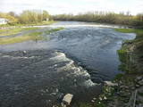 |
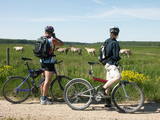
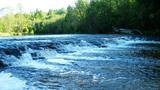
Above and below the town of Kuldīga, the Venta River is distinguished by a variety of biotopes – hillside forests, sandstone and dolomite cliffs, meadows, protected plants and animals, and diverse landscapes. There are popular tourism objects in this part of Kurzeme – the Venta dam, the stone bridge of Kuldīga, the Veckuldīga castle hill, etc. An ecological tourism trail runs along the banks of the Venta, and a bicycling trail has been installed on its left bank. |
|
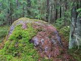 |
Комултенский валун находится в волости Сакстагалс, в
смешанном лесу, в 700 м от автомагистрали Екабпилс – Резекне,
на северо-востоке от деревни Комултени. Его плоский верх и бока
покрыты трещинами. Камень состоит из полосатого маг-
матического гнейса. Окружность камня 15 м, длина 5 м, ширина 3 м, высота 1,8 м; объем около
20 куб.м.
|
|
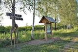 |
Kokneses dabas taka (5,65 km) ved gar Daugavas un Pērses krastiem un savieno Kokneses parku un Likteņdārzu. Pastaigā pa dabas taku var doties no jebkuras sevis izvēlētas vietas, kas vijas cauri Kokneses parkam. Takā izveidotas laipas, tiltiņi, informācijas stendi un norādes. |
|
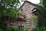 |
Atrodas Kraujā – Daugavas ielejas krasta malā un nogāzēs. Atrodama informācija, ka šajā vietā Livonijas kara laikā atradusies krievu karaspēka nometne. Muižas nosaukums cēlies no vācu Hof zum Berg – „Kalnu muiža”. Pēdējie muižas īpašnieki līdz 1. pasaules karam bija grāfu Šahno dzimtas pārstāvji. Viens no tiem – Marians Šahno 1910. gadā uzceļ muižas pili, kas bija būvēta eklektisma formās. Daļēji nojaukta tā pārdzīvo padomju laikus, līdz 2002. gadā nodeg. Līdz mūsdienām saglabājušās vien ēkas sienas, kuras slēpj biezs augājs. Var tikai iedomāties, kādi skati šeit kādreiz pavērušies uz Daugavas ieleju! Muižas parks ir vietējo iedzīvotāju pastaigu vieta. |
|
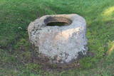 |
Находится около Улмалес, примерно в 300 м от шоссе Лиепая - Вентспилс (есть указатели). Очень красивый и ярко выраженный камень с углублением, в верхней части которого продолблено углубление глубиной 15 см и диаметром до 61 см. Предположительно, что здесь (особенно в 16 - 18 вв.) было старинное культовое место. |
|
 |
35 m wide and 0.5 m high, the
|
|
 |
One of the richest sources of sulphurous water in Latvia.
|
|
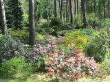 |
Проект по развитию дендрария начался в 1996 году, когда дендрологи Саласпилсского ботанического сада Раймондс Циновскис, Инара Бондаре и представители самоуправления Руцавы договорились о создании экспериментальных посадок на холме усадьбы Руцава. Посадка насаждений была начата в 1998 году. В дальнейшем, посадка растений проводилась также в центре Руцавы и у начальной школы. Посадки ежегодно пополняются новыми и экзотическими экземплярами растений со всего мира. Праздник сада традиционно проводится в мае, во время цветения рододендронов и магнолий. |
|
 |
This is the highest church tower in Latvia, and from it you can see views of the Alūksne highlands. The view to the South is particularly impressive.
|
|


