
Dabas objekti Igaunijā

Что особенного в природе в Эстонии?
В Эстонии стоит самая впечатляющая каменная стена в Балтии - так называемый северо-эстонский «глинт» (от эстонского языка). У Эстонии есть своя «Земля островов» - регион Лахемаа с национальным парком, «Земля островов» - остров Сааремаа и архипелаг Монцунд. Залив Матсалу является одной из наиболее значительных остановок для отдыха птиц во время их миграции. В Эстонии есть один из самых заметных ударных кратеров в Европе, самые большие водопады и валуны в Балтии, холм Мунамаги - самая высокая точка в Балтии, Чудское озеро - 5-е по величине озеро в Европе, - с длинной Постоянные рыболовные традиции и великое разнообразие природы с запада на восток, с севера на юг.
Действуй ответственно - следуй Зеленому совету!
| Pārskats | Detaļas |
|---|---|
 |
Igaunija
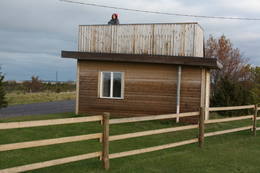
Perispeas pussala (Pärispea poolsaar)Perispeas pussalas piekrastē ir izvietojušies gan bijušie zvejniekciemi, gan Padomju armijas kara bāzu atliekas. Viena no pussalas savdabībām ir arī grandiozie ledāja atnestie dižakmeņi: nezinātājam ne visai viegli atrodamais un grūti pieejamais (jūrā) Odakivi, Purekari raga (Purekkari neem) galā starp citiem akmeņiem guļošais Purekari akmens (Purekkari rändrahn), jūras apskalotie Mehu akmeņi (Mähu kivid), Vīnistu (Viinistu) ciema krastmalā guļošais Melnais akmens (Must kivi), pāri niedru galotnēm savu „virsotni” izslējušais Kuhjakivi, visnotaļ iespaidīgais Painuva kivi, līdz kuram var nokļūt tikai peldus un savā ziņā nepārspējamais Jaani – Tooma suurkivi. Četri no pieminētajiem akmeņiem ir sasnieguši vai pat pārsniedz piecu metru augstumu! Akmeņiem bagāts ir Turbunēmes (Turbuneeme) ciems. Būs nepieciešams patiess entuziasms un laiks, lai visus uzskaitītos milžus atrastu un iemūžinātu savā fotokolekcijā. Perispeas pussala beidzas ar tālāko Igaunijas sauszemes ziemeļu punktu – Purekari ragu, kas ir ļoti ainaviska vieta.  74 74
Pakalpojumi
74km - Attālums no valsts galvaspilsētas |
 |
Igaunija
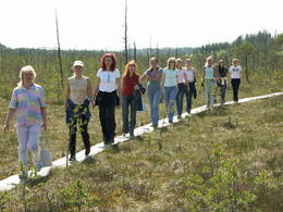
Ignatsi pārgājienu taka (Ignatsi matkarada)Taka iesākumā ved pa mežu ieskautu bijušo šaursliežu dzelzceļa līniju, pa kuru pagājušā gadsimta vidū izveda kokmateriālus. Tās tālākā daļa izmet nelielu loku pa Suistna purvu (Suistna raba), kur uzcelts skatu tornis ar izcilu sūnu purva ainavu ar nelieliem ezeriņiem. Takas garums vienā virzienā ir 4,5 km. |
 |
Igaunija
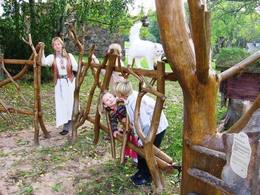
Meža večas ģimenes parks (Metsamoori Perepark)Meža večas ģimenes parks izveidojies starp Kaikas kupolveidīgajiem pauguriem, un sastāv no vairākām viensētām, kas piedāvā uzzināt par dabai tuvu, veselīgu dzīvesveidu un tautas medicīnu. Katrai viensētai ir sagatavota sava programma, kur apmeklētāji var iepazīties ar ārstniecības augiem, ārstēšanu ar dēlēm, bišu un sēņu noslēpumaino pasauli, izjust buramvārdu un meditāciju vietu ietekmi uz sevi. Te māca gatavot ēdienus no nezālēm, cept maizi un taisīt garšaugu maisījumus. Ar viensētām var iepazīties arī individuālie apmeklētāji. 275
 5-9 5-9
Pakalpojumi
275km - Attālums no valsts galvaspilsētas
5-9 Aktīvie sezonas mēneši |
 |
Igaunija
Majakivi akmens (Majakivi)Izmēru ziņā (584 m3, ~7 m augsts, apkārtmērs pie zemes – 32 m) Majakivi ir trešais lielākais Baltijas dižakmens. Tā tulkojums no igauņu valodas - „Mājas akmens” uzskatāmi pamato akmens izmērus. Majakivi ir iegūlis pārpurvotā mežā, kur to slēpj biezā koku lapotne. Akmens apskati ir jāapvieno ar pārgājienu pa Pikanõmme – Majakivi taku (4,5 km gara). Tās sākums ir meklējams Āblas purva (Aabla raba) rietumu malā, kur augstas ar priežu mežu apaugušas kāpas galā ir uzcelts skatu tornis ar lielisku sūnu purva ainavu. Pāri purvam un mitrākās vietās ir izveidotas laipas. Takas otrs „gals” meklējams pie Lēsi – Virves (Leesi – Virve) ceļa malas. 60
Pakalpojumi
60km - Attālums no valsts galvaspilsētas |
 |
Igaunija
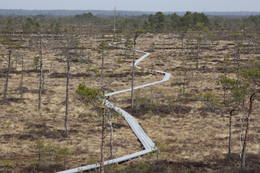
Hjupasāres pārgājienu taka (Hüpassaare matkarada)Iepazīstina ar Somā nacionālā parka lielākā purva – Kureso (Kuresoo) ziemeļaustrumu daļu, kur redzamas purva ezeriņu un lāmu ainavas. Takas sākumā atrodas igauņu komponista, ērģelnieka un folkloras vācēja Marta Sāra (Mart Saar) (1882. – 1963.) dzimtās mājas. To apkaimē pļavas apsaimnieko aitas. Lokveida takas garums ir 4,2 km. 169
Pakalpojumi
169km - Attālums no valsts galvaspilsētas |
 |
Igaunija
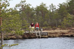
Ērdi taka (Öördi rada)1,2 km gara taka, kas pa purvainu mežu aizved līdz Ērdi purvam (Öördi raba) un tā austrumu daļā esošajam Ērdi ezeram (Öördi järv), pie kura izveidota atpūtas un peldvieta. |
 |
Igaunija
Kīdevas (Kiideva) putnu vērošanas platformasPirmā ir uzcelta uz vienstāvīgā apmeklētāju centra jumta. No tās paveras plašs skats uz Kīdevas ciemu, ostu un niedrēm apaugušo Matsalu līča ziemeļdaļu. Austrumos no šīs atrodas vēl viena - divstāvīga putnu vērošanas platforma. No Kīdevas līdz Puisei gar Matsalu līča var doties pārgājienā pa 5 km garo dabas taku. To izejot, novēroto putnu sugu klāsts noteikti būs lielāks! |
 |
Igaunija
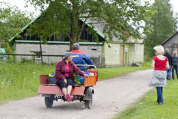
Kihnu salaUNESCO Pasaules mantojuma sarakstā iekļautā Kihnu kultūrtelpa (www.kultuuriruum.ee) ir savdabīgs mūsdienu un pagātnes sakausējums. Kihnu muzejā ir atrodami dažādi ar ikdienas dzīvi saistīti priekšmeti – darbarīki, apģērbi, rokdarbi, mēbeles. Metsamā tautas mantojuma sēta ir tradicionāls lauku sētas komplekss, kurā ir atspoguļota salas ikdienas dzīve. Šeit atradīsiet Kihnu salai raksturīgus mājsaimniecības darbarīkus, tautas tērpus un rokdarbus. Ekskursijas pa salu organizē Kihnurand AS (www.kihnurand.ee). 180
1-12
Pakalpojumi
180km - Attālums no valsts galvaspilsētas
1-12 Aktīvie sezonas mēneši |
 |
Igaunija
Skatu platforma Puises ciemāPuises „centrā” uz vienstāvu koka mājiņas jumta izveidota skatu platforma. No tās paveras laba ainava uz ciemu, ostu un piekrastes kadiķu laukiem. 121
Pakalpojumi
121km - Attālums no valsts galvaspilsētas |
 |
Igaunija
Rannajē putnu vērošanas tornis (Rannajõe linnutorn)Divstāvīgs skatu tornis pie Laikjula (Laiküla) – Hāpsalu ceļa, no kuras paveras plaša ainava uz Matsalu līcī ietekošo upīšu palieņu pļavām. Te var vērot migrējošās dzērves un zosis, bet pavasaros varbūt laimēsies redzēt vai dzirdēt ķikutu Gallinago media. Viens no retajiem torņiem, kas ir pielāgots cilvēkiem ar īpašām vajadzībām. |
 |
Igaunija
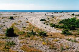
Osmusāre„Nomaļa” sala Somu līcī - 9 km attālumā no Dirhami ostas. Tās „vizītkarte” ir kadiķu lauki, akmeņaini – zāļains jūras krasts, ~ 2 km garš un dažus metrus augsts kaļķakmens atsegums – Osmussaare pank salas Z un A daļā.
|
 |
Igaunija
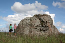
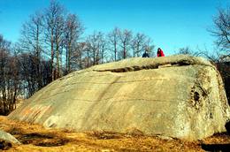
Tammispeas akmens (Tammispea kivi)Tikpat iespaidīgs, taču ne tik populārs tūrisma objekts kā netālu esošais Jāņa – Toma akmens. Tammispeas akmens iegūlis mežā, tāda paša nosaukuma nelielā ciemā, kas atrodas Eru līča (Eru laht) dienvidu krastā. Tilpuma ziņā (262 m3) – 16. lielākais Igaunijas dižakmens. Tā garums ir 10,7 m, platums – 6,5 m, augstums – 7,5 m, bet apkārtmērs – 27,8 m. Iespaidīgas ir arī šī akmens atlūzas. Ar šī akmens attēlu noteikti ir jāpapildina sava lielāko Baltijas dižakmeņu fotokolekcija. 70
Pakalpojumi
70km - Attālums no valsts galvaspilsētas |
 |
Igaunija
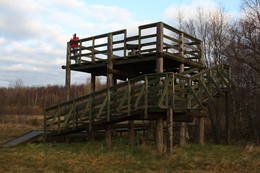
Mēkonnu skatu tornis (Mäekonnu vaatetorn)Viens no diviem nacionālā parka skatu torņiem, kas atrodas ~ 1,5 km ziemeļos no Ehijerva ezera (Ähijärv). Tornis ir veiksmīgi „nomaskēts” nelielā priežu pudurī, tādēļ tas „nebojā” izcilo dabas un kultūrainavu, kas paveras no tā skatu platformas. Pie autostāvlaukuma ir izveidota labiekārtota atpūtas vieta. |
 |
Igaunija
Tuhalas dabas centrs un Raganas aka (Nõiakaev)Tuhalas apkārtne ir apdzīvota vismaz 3000 gadus. Šeit ir atrastas 11 senas apmetnes, 30 kulta akmeņi, 3 akmens senkapi, 4 svētbirzes u.c. Tuhalas lieguma teritorijā atrodas unikālā Nõiakaev (Raganas aka), kas palu laikā “vārās” un izmet 100 litrus ūdens sekundē, kā arī pieci Igaunijas spēcīgākie enerģijas stabi. Pa pastaigu ceļu, kas šķērso Tuhalas karsta procesu teritoriju (2,5 km), var iet kājām, vai braukt ar velosipēdu un automobili. Šis ceļš ir piemērots pastaigām kopā ar ģimeni. 32
1-12
Pakalpojumi
32km - Attālums no valsts galvaspilsētas
1-12 Aktīvie sezonas mēneši |
 |
Igaunija
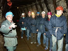
Degslāneklis jeb degakmensDegslānekli – Igaunijas enerģētikas un ķīmiskās rūpniecības galveno izejvielu mūsdienās iegūst atklātos karjeros vai pazemes šahtās. Šis nogulumiezis sācis veidoties Ordovika periodā (pirms ~ 450 - 480 mlj. g.) no tā laika augu un dzīvnieku atliekām. Kohtla – Nõmme piepilsētā vienā no izstrādātajām šahtām gida pavadībā var aplūkot gan šo nogulumiezi (Baltijas valstīs atradnes tikai Igaunijā), gan arī iepazīt tā ieguves veidus un vēsturi.
PakalpojumiPakalpojumi - atpūta
Dabas vērošanaSavukārt, Kivieli (Kiviõli) ciemā var uzkāpt Vecajā degakmens izdedžu kalnā (Vana tuhamägi), no kura paveras viena no savdabīgākajām Igaunijas ainavām. Informācija: www.kivioli.ee |
 |
Igaunija
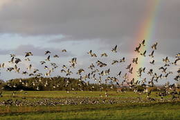
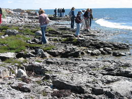
Matsalu nacionālais parksViena no iecienītākajām Igaunijas putnu vērošanas vietām, kur pavasara un rudens migrāciju laikā ir novērojama liela sugu daudzveidība un zosveidīgo putnu bari, kas atpūšas un barojas Matsalu līča un Kazari (Kasari) upes palieņu pļavās un seklajos piekrastes ūdeņos.
Pakalpojumi
1-12 Aktīvie sezonas mēnešiPakalpojumi - atpūta
Izbraukumi ar kuģīti/laivuOrganizēti braucieni pa Matsalu līci un Kazari upi 
Dabas takaKiideva – Puise pārgājienu taka (5 km), Penijõe taka (3 km), Salevere izziņas taka (1,5 km)
Dabas vērošanaPutnu vērošana- visā parkā, īpaši – piekrastē, palieņu pļavās, tīrumos; Putnu vērošanas torņi vai platformas meklējamas: Puise, Kiideva, Haeska, Rannajõe, Kasari jõgi, Penijõe, Suitsu, Keemu. Apmeklētāju centrs atrodas Matsalu ciemā. Informācija: www.matsalu.ee |
 |
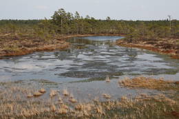
Igaunija
Mēnikunno purvsAugstā purva masīvs ar vairākiem purva ezeriņiem, kura DA daļā izveidota laipu taka.
|
 |
Igaunija
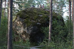
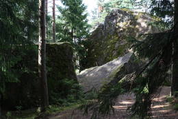
Mūgas Kabelikivi akmensPēc tilpuma (728 m3) - otrs lielākais Baltijas dižakmens. Baltijā vienīgais akmens ar šādu formas un izmēra apvienojumu. Tā augstums ir 7 m, garums – 19 m, platums – 11 m, bet apkārtmērs – 58 m. Kabelikivi atgādina līdz pusei zemē ieraktu milzu klints gabalu. Ledājs to „atnesis” no Somijas D daļas. Pēc sastāva - rapakivi granīts. Tam blakus atrodas vēl 2 visnotaļ iespaidīgi dižakmeņi.
|
 |
Igaunija
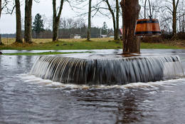
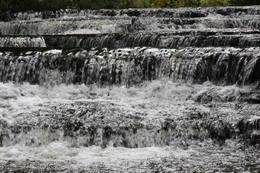
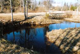
Joaveski ūdenskritumi (Joaveski joastik)Krāčains Lobu upes (Loobu jõgi) posms pie Joaveski ciema, kur ~ 160 m garumā upes gultnē, tai šķērsojot Ziemeļigaunijas glintu, izveidojušās izmēros nelielas, tomēr ļoti ainaviskas un skaistas 0,5 – 1 m augstas ūdenskritumu kaskādes. 1898. g. šeit uzcēla hidroelektrostaciju, kuras atliekas ir redzamas upes labajā krastā. Iecienīta pavasara laivotāju treniņu vieta. |
 |
Igaunija
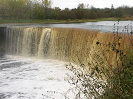
Jegalas ūdenskritumsViens no izcilākajiem Baltijas ūdenskritumiem – ap 8 m augsts un līdz 70 m plats (iespaidīgāks pavasaros un pēc lietavām). Ūdenskritums un tam sekojošais ~ 300 m garais kanjons veidojies Ordovika perioda kaļķakmeņos, kuros zinātājs saskatīs galvkāju u.c. fosīlijas. Mazūdens periodā drosmīgākie mēģina šķērsot upes straumi gan virs ūdenskrituma, gan arī zem tā, kur kaļķakmens pārkares un krītošais ūdens ir izveidojuši savdabīgu „tuneli”.
|
 |
Igaunija
Hiiumaa salaOtra lielākā Igaunijas sala ar plašiem mežu masīviem, smilšainām un akmeņainām pludmalēm un vienu no Eiropas vecākajām bākām. 132
Pakalpojumi
132km - Attālums no valsts galvaspilsētas |
 |
Igaunija
Voremā drumlinu lauksTabivere ciems. Drumlinus veidojis ledājs un tie orientēti ledāja kustības virzienā. Pēc izskata drumlini atgādina klaipveida paugurus. No to „mugurām” paveras skaisti skati uz drumlinu lauka ainavu un ieplakās esošajiem ezeriem. Apmeklētāju centrs atrodas Äksi ciemā.
|
 |
Igaunija
Nemmeveski ūdenskritums (Nõmmeveski juga)No vairākiem parka ūdenskritumiem noteikti ir jāapmeklē divi. 1,2 m augstais vienpakāpes Nemmeveski ir izveidojies uz Valgejegi upes (Valgejõgi), vietā kur tā šķērso Ziemeļigaunijas glintu. Šeit Valgejegi atgādina krāčainu (īpaši – pavasaros) kalnu upi, kas plūst pa vairākus metrus augstu klinšu ieskautu kanjonu. Palu laikā šo upes posmu ir iecienījuši ekstrēmie ūdenssporta veidu cienītāji. Pie ūdenskrituma un tālāk pa upi lejup redzamas ap 1920. g. celtās hidroelektrostacijas konstrukciju paliekas. |
 |
Igaunija
Vilsandi nacionālais parksVeidots Vilsandi salu arhipelāga (~ 100 mazas saliņas) aizsardzībai. Lielākā no salām – Vilsandi ir 6 km gara un līdz 2 km plata. Līdz Vilsandi var nokļūt ar savu vai īrētu laivu, kā arī piemērotos apstākļos ar kājām, - veicot neparastu ~ 5 km garu pārgājienu pa jūru un mazām saliņām no Kuusnõmme pussalas Z gala.
Pakalpojumi
255km - Attālums no valsts galvaspilsētasPakalpojumi - atpūta
Izbraukumi ar kuģīti/laivuBrauciens ar jūras laivu vai jūras kajaku pa arhipelāga salām (Vaikas salas un Nootamaa sala ir dabas rezervāti un to apmeklējums ir aizliegts!);
Dabas takaPārgājienu maršruts Loona – Kuusnõmme (8 km), pārgājiens pa Vilsandi salu (~ 12 – 15 km), pārgājiens pa Harilaid pussalu (~ 10 km);
Dabas vērošanaPutnu vērošana Vaikas salās (Vaika saared) no Vilsandi R krasta (Vaikas salu apmeklējums aizliegts!); Skatu tornis Kuusnõmme pussalas Z galā. Apmeklētāju centrs atrodas Lonas muižā (Loona mõis). |
 |
Igaunija
Tuhalas karsta lauks, Raganu akaViens no lielākajiem Igaunijas karsta laukiem. Tā interesantākais dabas veidojums ir unikālā Raganu aka, pa kuru pavasara palos (ne katru gadu un salīdzinoši īsu laika brīdi!) izplūst pazemes upes ūdeņi, veidojot neparasti spēcīgu karsta avotu, kura izvirstais ūdens daudzums var sasniegt 100 l/s.
|
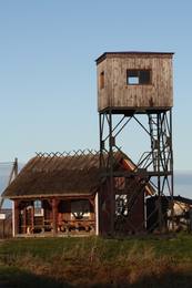 |
Igaunija
Kēmu skatu tornis (Keemu vaatetorn)Meklējams Matsalu līča dienvidu krastā pie Kēmu ostas (Keemu sadam). Blakus sešus metrus augstajam metāla – koka tornim uzcelts neliels apmeklētāju centrs. Tāpat kā no Haeskas torņa, arī no šī paveras viena no izcilākajām Matsalu līča un tā piekrastes ainavām. Laba putnu vērošanas vieta migrāciju laikā. 129
Pakalpojumi
129km - Attālums no valsts galvaspilsētas |
 |
Igaunija
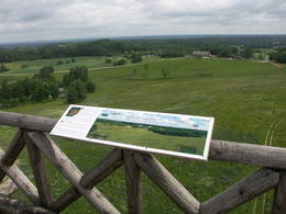
Torņa kalns (Tornimägi)Karulas augstienes augstākais reljefa punkts (137 m.vjl.), kas virs tuvākās apkārtnes paceļas par ~ 60 m. Torņa kalnā ir uzbūvēts skatu tornis ar ļoti plašu apkārtskatu. Uz tā platformas ir novietoti panorāmas fotoattēli, kuros atzīmēti zīmīgākie plašākā apkaimē redzamie objekti – apdzīvotas vietas, pilskalni, baznīcu torņi u.c. Turpat izveidota atpūtas vieta un meklējams Rebases ainavu takas sākums. 260
Pakalpojumi
260km - Attālums no valsts galvaspilsētas |
 |
Igaunija
PīrisārePīrissāre ir 7,5 km² liela pastāvīgi apdzīvota Peipusa ezera sala. Pārsvarā šeit uz dzīvi ir apmetušies krievu vecticībnieki, kas vairākus gadsimtus rūpējas par savas savdabīgās kultūras saglabāšanu. Iedzīvotāji galvenokārt nodarbojas ar zvejniecību. Uz lauksaimniecībai piemērotas zemes audzē dārzeņus, visvairāk – sīpolus. Uz Pīrisāri no Lāksāres ostas var nokļūt ar prāmi "Koidula" (tālr.: +372 527 2974, www.veeteed.com). 262
1-12
Pakalpojumi
262km - Attālums no valsts galvaspilsētas
1-12 Aktīvie sezonas mēneši |
 |
Igaunija
Tolkuse purvsCauri purvam un augstākajam Igaunijas kāpu masīvam izveidota izziņas taka. Skatu tornis ar skatu līdz pat Kihnu salai. 175
Pakalpojumi
175km - Attālums no valsts galvaspilsētas |
 |
Igaunija
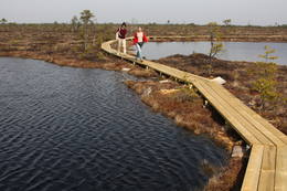
Soomā nacionālais parks1993. gadā dibinātais Soomā nacionālais parks aizsargā lielo purvu masīvus, palienes pļavas un mežus. Parka apmeklētāju centrā ir pieejama informācija par pārgājienu takām un vietējiem pakalpojumiem. Pieejamas vairāk kā 10 dabas takas un skatu torņi. Šeit varat iepazīties ar pastāvīgo ekspozīciju un doties tematiskā mācību pārgājienā par bebru dzīvi. Soomā ir plaši pazīstams vērienīgo plūdu (martā un aprīlī) dēļ, ko sauc par piekto gadalaiku. Plūdu laikā pa Soomā mežiem, pļavām un upēm tiek organizēti pārgājieni ar kanoe laivām un vienkocēm (www.soomaa.com). Te var apgūt vienkoču grebšanas prasmi un piedalīties nometnēs. Pakalpojumi
150km - Attālums no valsts galvaspilsētas
1-12 Aktīvie sezonas mēnešiPakalpojumi - atpūta
Makšķerēšana
Apvidus slēpošanaApvidus slēpošana un purva šķērsošana ziemā. Apmeklētāj centrs atrodas Tõramaa. Informācija: www.soomaa.com, www.soomaa.ee
Izbraukumi ar kuģīti/laivuBraucieni ar kanoe laivām pa applūdušajām teritorijām un nacionālā parka upēm.
Dabas takaWalking tours in the park
Dabas takaGidēts pārgājiens „purva kurpēs”, Riisa purva taka (5 km) ar skatu torni , Ignatsi pārgājienu taka (4,5 km) ar skatu torni , Bebru izziņas taka (3 km), Tõramaa taka (2,5 km) ar skatu torni u.c. takas un maršruti.
Dabas vērošanaBebru safari, dzīvnieku vērošana gida pavadībā. |


