
Dabas objekti Igaunijā

Что особенного в природе в Эстонии?
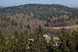
В Эстонии стоит самая впечатляющая каменная стена в Балтии - так называемый северо-эстонский «глинт» (от эстонского языка). У Эстонии есть своя «Земля островов» - регион Лахемаа с национальным парком, «Земля островов» - остров Сааремаа и архипелаг Монцунд. Залив Матсалу является одной из наиболее значительных остановок для отдыха птиц во время их миграции. В Эстонии есть один из самых заметных ударных кратеров в Европе, самые большие водопады и валуны в Балтии, холм Мунамаги - самая высокая точка в Балтии, Чудское озеро - 5-е по величине озеро в Европе, - с длинной Постоянные рыболовные традиции и великое разнообразие природы с запада на восток, с севера на юг.
Действуй ответственно - следуй Зеленому совету!
| Pārskats | Detaļas |
|---|---|
 |
Igaunija
Vehandu upes senlejaViena no skaistākajām Igaunijas upju senlejām – 12 km gara ar gandrīz 40 ainaviskiem Devona perioda smilšakmens atsegumiem, no kuriem īpaši jāpiemin Viira müür, Kalamatu müür un Põdramüür.
|
 |
Igaunija
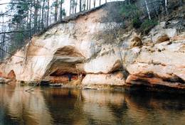
Turisalu klintsLīdz 30 m augsts smilšakmens (lejasdaļā) un kaļķakmens (augšdaļā) atsegums (Ziemeļigaunijas glinta daļa) Somu līča krastā – populārs tūrisma objekts un skatu vieta. Ieteicams pārgājiens gar klinšu lejasdaļu (akmeņains liedags) vienā virzienā un pa tās augšdaļu – atpakaļ (~ 2 km). No klints augšas pārskatāma plaša piekrastes teritorija līdz pat Tallinai. Izveidota skatu vieta. |
 |
Igaunija
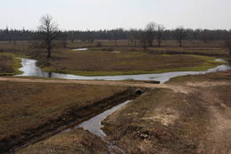
Penijē tornis (Penijõe torn)Lai nokļūtu līdz šim tornim, ir jāveic apmēram 20 – 30 min ilgs pārgājiens pa dabas taku no Penijē muižas gar Penijegi (Penijõgi) kreiso krastu. Te redzami bebru darbi un to celtās zaru mājas. No torņa paveras skats uz Kazari deltu, kas dabā izpaužas kā monolīts un nepārskatāms niedrājs. To vairākās daļās sadala Kazari un mazāka izmēra upītes. Katrai deltas daļai ir savs vēsturiskais nosaukums: no torņa pa kreisi no Penijegi redzama Lihula meri (Lihulas „jūra”), bet tās labajā pusē - Kloostri meri (Klostri „jūra”). Putnu vērotāji var iziet garāku (7 km) dabas takas loku, kas ved pa palieņu pļavām. Jārēķinās, ka pavasaros būs nepieciešami piemēroti apavi! Pļavas ierobežotās platībās apsaimnieko mājdzīvnieki, tādēļ neaizmirstiet aizvērt vārtiņus aiz sevis un netraucējiet to ikdienas gaitas! No maršruta nav atļauts novirzīties, lai netraucētu putnus. |
 |
Igaunija
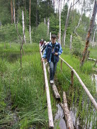
Viru purva taka (Viru raba matkarada)3,5 kilometrus gara taka, kas Viru purvu šķērso dienvidu – ziemeļu virzienā. Takas sākums ir jāmeklē pie Vahastu – Loksas (Loksa) ceļa. Viru purvā ir uzcelts koka skatu tornis, no kura atklājas tipiska sūnu (augstā) purva ainava ar nelielu ezeriņu, lāmu un akaču kopu. Taka nav lokveida, tādēļ ir jāpadomā par šī maršruta veikšanas loģistiku! Tās apskatei būs nepieciešama ~ 1h. Jāpiebilst, ka šī ir viena no interesantākajām nacionālā parka takām!  56 56
Pakalpojumi
56km - Attālums no valsts galvaspilsētas |
 |
Igaunija
KasariPiektā lielākā Igaunijas sala. Dabas takas, putnu vērošanas tornis, Kassari kapela (18. gs.) un Sääre tirp oļu strēle, pa kuru var doties 3 km garā pārgājienā. Ar Hījumā to savieno divi dambji, pa kuriem uzbūvēts autoceļš. Pakalpojumi
150km - Attālums no valsts galvaspilsētasPakalpojumi - atpūta
VelomaršrutsKäina – Orjaku – Kassari – Esiküla – Käina (22 km); 
Dabas takaOrjaku dabas izziņas taka (līdz 2 km), Sääre tirp – gājiens pa 3 km garu akmeņainu zemes strēli Kasari D daļā 
Dabas vērošanaKeinas (Käina) līcī (jūraskraukļu kolonija, ūdensputni u.c.) un pārējā salas piekrastē; Orjaku putnu vērošanas tornis, skatu platforma pie Vemlas līča (Vaemla laht). |
 |
Igaunija
Tahkuna ragsTālākais Hiiumaa salas ziemeļu punkts. Igaunijas augstākā čuguna bāka (1873. – 1875. g.) un piemineklis kuģa „Estonia” bojā gājušo piemiņai. 175
Pakalpojumi
175km - Attālums no valsts galvaspilsētas |
|
|
Igaunija
Otepää pilskalnsĻoti izteikta un cilvēka apdarināta reljefa forma ar plašu skatu uz apkaimi. Tā virsotnē atrodas 1224. g. bīskapa Hermaņa celtās pils drupas. Izrakumos atrasts pasaulē vecākais šaujamierocis. 225
Pakalpojumi
225km - Attālums no valsts galvaspilsētas |
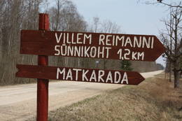 |
Igaunija
Paunas taka (Pauna rada)Kultūrvēsturiska taka (garums ~ 2 km) Tipu (Tipu) ciemā, kas iepazīstina ar vairākiem interesantiem objektiem: veco skolu (1931. g.), Hallistes upi, pirti un Paunas saimniecību, kurā dzimis viens no Igaunijas nacionālās kustības līderiem Villems Reimans (1861. – 1917.). |
 |
Igaunija
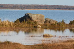
Nēri akmeņi (Näärikivid)Trīs lielāka izmēra laukakmeņi – aizsargājami dabas pieminekļi, kas atrodas Matsalu līča krastā starp Sāstnas (Saastna) un Metskjulas (Metsküla) ciemiem. Tuvējā ceļa malā ir izvietots informācijas stends un norādes, bet līdz akmeņiem var nokļūt pa iezīmētu taku. Pēc kāda tautas nostāsta, lielas vētras laikā, kas notikusi Jaungada naktī, lielais akmens sašķēlies trīs daļās. No tā arī cēlies vietvārds. Apkārtnē redzamās pļavas ir nozīmīga daudzu augu sugu dzīves vide un svarīga putnu ligzdošanas un atpūtas vieta. Šī iemesla dēļ taku drīkst apmeklēt tikai no 1. jūlija līdz septembra beigām. Akmeņi ir arī labi redzami no minētā ceļa. Tie ar ledāju atceļojuši no Turku (Somija) apkārtnes. 129
Pakalpojumi
129km - Attālums no valsts galvaspilsētas |
 |
Igaunija
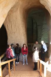
Piusas upes senleja un Piusas alas~ 15 km garš Piusas senlejas posms starp Vana - Vastseliina un Ignasõ ciemiem, kur upei novērojams liels kritums, ātras straujteces un skaisti Devona perioda smilšakmens atsegumi, no kuriem Hermas siena (Härma müür) ir augstākais (ar senlejas nogāzi – 43 m) smilšakmens atsegums Igaunijā. Piusas ciemā atrodas Piusas raktuvju alas. Tikai pavisam neliela daļa no > 10 km garās Piusas raktuvju sistēmas ir eksponētas un labiekārtotas kā apskates objekts.
PakalpojumiPakalpojumi - atpūta
Izbraukumi ar kuģīti/laivuIzbraukums ar laivu pa Vana - Vastseliina - Ignasõ (1 diena, ekstrēms, tikai palu laikā). Informācija: www.piusa.ee.
Dabas takaPārgājiens gar upi visā senlejas garumā (~ 20 km). |
 |
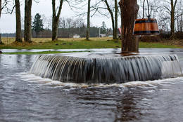
Igaunija
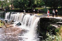
Keilas ūdenskritumsViens no Igaunijas ainaviskākajiem ūdenskritumiem – līdz 6 m augsts un līdz 50 m plats. Straujā Keilas upe aiz ūdenskrituma izveidojusi klinšainu kanjonu un tecējumu ar lielu kritumu, tādēļ pa Keilas parku vērts aiziet līdz ~ 1 km attālajam Somu līča krastam un atgriezties gar upes otru krastu.
|
|
|
Igaunija
Otepää slēpošanas centrsLielākais Baltijas valstīs. Tartu maratona trase, mākslīgo klinšu siena un velomaratorna trase. Slēpju muzejs. Tehvandi tramplīnā – skatu platforma. 225
Pakalpojumi
225km - Attālums no valsts galvaspilsētas |
 |
Igaunija
Vikingu ciematsUnikālais tematiskais parks pirmatnējās Piritas upes krastā ir izveidots ar mērķi apmeklētājiem raisīt interesi par seno vikingu diženumu. Iespējas: vikingu pils, buršanās slietenis, smēde, senlaiku spēles, teatralizēti uzvedumi, izbrauciens vikingu kuģi pa Piritas upi bagātību meklējumos, vizināšanās vienkoču laivās, kaujas ar akmeņu metamām ierīcēm, loka šaušana, cirvja mešana, alas un melnā pirts, foreļu makšķerēšana, ekstrēma nakšņošana, ēdināšana u.tml.  30
30
 1-12 1-12
Pakalpojumi
30km - Attālums no valsts galvaspilsētas
1-12 Aktīvie sezonas mēneši |
 |
Igaunija
Tēramā taka (Tõramaa matkarada)Divarpus kilometrus gara taka (vienā virzienā) aizved līdz Hallistes palieņu pļavām, kur Hallistes upes labajā krastā ir uzcelts divstāvīgs koka skatu tornis. No tā paveras visaptverošs skats uz atjaunotajām (izcirsti krūmi) Hallistes palieņu pļavām. Pavasara palu laikā no torņa redzamā apkārtne un tornis atrodas ūdenī. |
 |
Igaunija
Kostiveres karsta lauksIgaunijas vizuāli izteiksmīgākais karsta lauks 125 ha platībā ar dažādām karsta procesu izpausmēm – pazemes strautiem, Jēlehtmes (Jõelähtme) upes sausgultni, karsta avotiem, piltuvēm, gravām, alām, pamatiežu atsegumiem, savdabīgu akmens „sēni” u.c. Pavasaros tas applūst, bet mazūdens periodā labi apskatāmas minētās karsta formas.
|
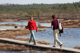 |
Igaunija
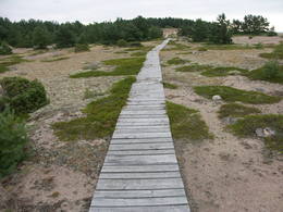
Rīsas purva taka (Riisa rabarada)Izcila lokveida taka (4,5 km), kuras lielākā daļa (koka laipas) ved pa Rīsas purvu (Riisa raba). No takas un divstāvīgā koka skatu torņa ir vērojami purva ezeriņi, lāmas, un purvaini meži. Ja nacionālā parka apskati sāk no ziemeļu puses, tad šī taka ir labs ceļojuma iesākums! |
 |
Igaunija
The Haanja Nature ParkThis park was set up to protect the landscape and cultural environment of the Haanja highland. At the central part of the park are the two highest hills in the Baltic States – Suur Munamägi, which stands 318 m above sea level, and Vällamägi, which is 304 m above sea level. The ancient Rõuge River valley (Rõuge ürgorg) is found in the western part of the park. It is 7.5 km long and up to 60 m deep. The valley dates back to the Ice Age, and it has seven lakes, including the deepest one (38 m) in Estonia – Lake Rõuge Suurjärv.
УслугиСервисы - отдых
ВеломаршрутBike the route Rõuge-Nursi-Tindi-Rõuge (15 km).
Природная тропаThe Vällamäe nature trail (2.2 km) is the highest trail in terms of elevation in the Baltic States. You may hike the wooden trail of the Hinni canyon and the hiking route of the Rõuge River valley (10 km), or the trail of Lake Kavadi (Kavadi järv) (4.5 km).
Наблюдение за природойThere are viewing towers at Suur Munamägi and on the eastern shore of Rõuge Suurjärv. For more information: www.haanjapark.ee (only in Estonian). |
 |
Эстония
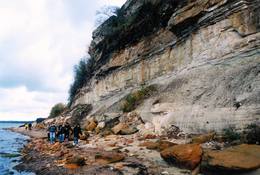
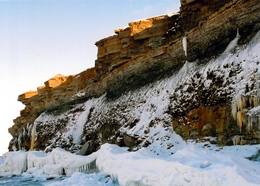
Felsen PakriDie mächtigste Steilküste im Baltikum (bis zu 24 m hoch). In den kalten Winter werden hier phantastische Gletscherstürze entstanden. Pakri Leuchtturm. 50
Услуги
50km - Расстояние от столицы |
 |
Эстония
Rebases ainavu taka (Rebäse maastikurada)Ap 7 km garš lokveida pārgājienu maršruts (marķēts), kas ved pa dažādiem biotopiem – mežiem, mitrājiem un pļavām, mezdams līkumus pa stāvo pauguru nogāzēm. Takas malās ir izvietoti informācijas stendi un norādes. Rebases ainavu taka ir domāta tiem, kurus nebaida garāka iešana un orientēšanās pa ļoti dabisku un mazapdzīvotu apvidu. |
 |
Эстония
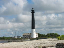
Mohni sala (Mohni saar)Igaunijas jūras ūdeņos ir saskaitīta 1521 sala! Salu sarakstā pēc platības (63 ha) ~ 2,5 km garā Mohni sala ieņem 38. vietu. Lai saudzētu salas trauslo veģetāciju (vietām nedaudz atgādina krūmainu tundru), tās vidusdaļā ir izveidotas koka laipas. Salas dienviddaļā atrodas sašaurinājums, kuru tāpat kā blakus esošo jūras krastu klāj viens no savdabīgākajiem Igaunijas akmeņu laukiem. Salas ziemeļos esošās Mohni bākas (Mohni tuletorn) celtniecība pabeigta 1871. g. un tās gaisma ir redzama 10 jūras jūdžu attālumā. Šī ir viena no skaistākajām Ziemeļigaunijas bākām! Līdz Mohni salai var nokļūt ar laivu (iepriekšēja pieteikšanās) no ~ 5 km attālās Vīnistu ostas (Viinistu sadam). Ar jūras laivu vai kajaku piemērotos apstākļos būs ~ 1h ilgs brauciens. Jārēķinās, ka uz salas nav pastāvīgo iedzīvotāju! Vīnistu ciemā apskatāms 2002. g. izveidotais Vīnistu mākslas muzejs (Viinistu kunstimuuseum). Apmeklētājus iespaidos ne tikai tā āriene, bet arī tapšanas vēsture. 76
Услуги
76km - Расстояние от столицы |
 |
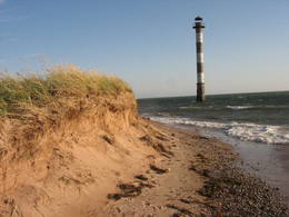
Эстония
Sõrve säärDie Südspitze der Insel Saaremaa – eine aus Geröll in der Irbenstraße langgestreckte Landzunge. Militärbefestigungen, Leuchtturm (1960), Vogelbeobachtungsort. 270
Услуги
270km - Расстояние от столицы |
 |
Эстония
Saaremaa IslandThe biggest sea island in Estonia. In translation - "Land of The Islands". A bridge, where cyclists can drive connects Saaremaa island to Muhu island . 160
Услуги
160km - Расстояние от столицы |
 |
Эстония
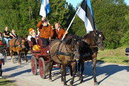
Туристический конный хутор Тихусе и тропа древней культурыТуристический конный хутор Тихусе предлагает размещение и конные прогулки(от езды на коляске до конных прогулок). У хутора начинается учебная тропа древней культуры, которая уводит нас в те времена, когда человек связывал себя с силами природы, где можно познакомиться с обычаями и традициями прежних времен. Стены хуторского чайного дома украшают фотографии различных мест Мухумаа, связанных с древней культурой. 148
1-12
Услуги
148km - Расстояние от столицы
1-12 Месяцы активного сезона |
 |
Эстония
Mejekoses pargajienu taka (Meiekose matkarada)~ 3 – 5 km gara taka, kas ved pa veco ceļu gar Tēramā upes (Tõramaa jõgi) kreiso krastu. Takas malās izvietoti interaktīvi elementi bērniem, kas palīdz labāk uztvert dabā notiekošo. Taku ieskauj mitrie meži un palieņu pļavas, kas palu laikā atrodas zem ūdens. Tēramā (Tõramaa) ciemā apkārtnē atrastas cilvēka darbības pēdas jau no akmens laikmeta. 149
Услуги
149km - Расстояние от столицы |
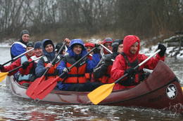 |
Эстония
Приключенческая фирма 360 градусовКомпания занимается организацией природных походов: летом морские походы на байдарке, осенью на болотоступах по болоту, зимой походы на снегоступах и весной на каноэ по рекам. 37
1-12
Услуги
37km - Расстояние от столицы
1-12 Месяцы активного сезона |
 |
Эстония
Oksas (Oksa) takaBijušā piecstāvīgā metāla skatu torņa apkaimē plešas Lemmjegi upes palieņu pļavas. Netālu atrodas kādreizējā Oksas kroga (Oksa kõrts) vieta, kur saglabājies iespaidīgs manteļskurstenis. Apkaimes apskatei izveidota 0,8 km gara koka laipu taka. 175
Услуги
175km - Расстояние от столицы |
 |
Эстония
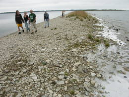
Harilaidas pussala (Harilaid)Sāmsalas ziemeļrietumu daļā jūrā iestiepjas iespaidīgā Tagameizas pussala (Tagamõisa poolsaar). Tās ziemeļrietumu daļā meklējama mazāka – ap 5 km garā Harilaidas pussala (Harilaid). Pussalas vidusdaļā viļņojas Lajalepas ezers (Laialepa järv) - bijušais jūras līcis, kas zemes garozai ceļoties, kļuvis par iekšēju ūdenstilpi. Arī pati Harilaida (igauniski „laid” nozīmē „saliņa”) vairāk nekā trīs gadsimtus atpakaļ bijusi sala. Harilaidu iecienījuši ne tikai migrējošie putni, bet arī roņi, kurus piesaista vientuļi līči un akmeņainās sēres. Harilaidu var apmeklēt tikai ar kājām vai ar divriteni, bet spēkrati ir jāatstāj autostāvlaukumā. No tā ~ 1 km attālumā atrodas vieta, kur pēc 17. gs. radies Harilaidas savienojums ar Sāmsalu. Šeit paveras nepierasti klaja un akmeņaina ainava. Pārējā Harilaidas daļa ir apmežota pirms ~ 40 gadiem. Kopumā būs jāveic ~ 10 km garš pārgājiens. 273
Услуги
273km - Расстояние от столицы |
 |
Эстония
Domberg TartuVom 19. Jh. ist der Domberg ein offentlicher Park mit Pfaden, Gehwegen, Brücken (Engelsbrücke, Teufelsbrücke) und den Denkmälern für die Wissenschaftler der Tartu Universität. Hier befinden sich die Domkirche, das Anatomicum, das Observatorium u.a. interessante Objekte. 185
Услуги
185km - Расстояние от столицы |
|
|
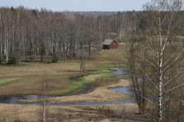
Эстония
Lemmje pargajienu taka (Lemmjõe matkarada)Taka, kas izveidota Lemmjegi (Lemmjõgi) un Raudnas (Raudna jõgi) satekas vietā, iepazīstina ar palieņu pļavām un veciem pārmitriem mežiem, kas ir vieni no lielākajiem Igaunijā. Takas sākumā dominē atklātas lauku ainavas. Viens no 4,9 km garās lokveida takas apskates objektiem ir Lemjē dižozols. Mitrā laikā noderēs ūdensizturīgi apavi. 155
Услуги
155km - Расстояние от столицы |
 |
Эстония
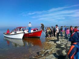
Туристическая фирма Heritage ToursПредприятие организует природные походы, целью которых является знакомство с природой (наблюдение за тюленями, пешие, велосипедные и лыжные природные походы, на резиновых лодках по островкам национального парка Вилсанди, вылазки к орхидеям и т. д.) и культурным наследием (мыза, сельская и городская жизнь, сегодняшний день Эстонского ремесла, морское наследие). В находящемся на территории национального парка Вилсанди лесном парке Мику можно познакомиться со старинными работами в лесу и даже поучаствовать в них. 200
1-12
Услуги
200km - Расстояние от столицы
1-12 Месяцы активного сезона |


