
| No | Name | Description |
|---|---|---|
 |
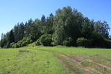
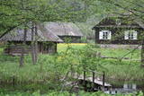
The Smārde saloon has a very long history,
and food is served here. There is a car park, and
approx. 100 m to the East is a cemetery and
monument to commemorate soldiers who fell
during World War II.
|
|
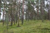 |
This may be an ancient cult object, and today it is a little hill in the dunes that is a bit larger than other local hills. It is said that a church once sank into the dune. This tale suggests that there was a Christian or pagan prayer place here at one time. (Source: Roja TIC) |
|
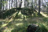 |
Near the place where the Kilmiņupe River flows into the sea is the legendary Trommel castle hill, which was a Medieval fortification. It is some 100 m from the Kraujas homestead. An archaeological dig in 1977 found fragments of bricks and pot-bellied stoves, which suggests that the fortifications date back to the Middle Ages. The location also is linked to stories about a pirate, Trommel, who buried his loot here. The holes in the area have been left behind by treasure hunters. Trommel supposedly robbed ships in the Bay of Rīga from the shores of Kurzeme to Roņu Island. Many ships docked here in ancient times, waiting for better winds so that they could pass by Cape Kolka. The pirate made use of this fact, also pillaging property from sunken ships. It is said that Trommel lived in a stone castle. (Source: Roja TIC) |
|
 |
Tiek uzskatīta par vecāko alus darītavu Ziemeļeiropā. Tā tika uzcelta 1878. gadā, un tās pirmais īpašnieks bija grāfs Emanuels fon Zīverss (Sievers), Cēsu pils muižas saimnieks. Savukārt 1922. gadā alus darītavu pārpirka Cēsu uzņēmēji un sāka tur ražot arī vīnu, sulas un minerālūdeni. Uzņēmums "Cēsu alus" šeit alu un atspirdzinošus dzērienus ražoja no 1976. līdz 2001. gadam, bet šobrīd tas ir pārcēlies uz jaunām telpām. Šobrīd ēkā tiek organizētas dažādas izstādes, kā arī ēku var apskatīt no ārpuses. |
|
 |
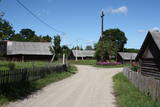
A haven for Russian Old Believers. Mustvee village has held fairs for the past two centuries. It is also a traditional fishing town. |
|
 |
Stupeļu Hill is 3 km to the South of the Vecumnieki-Ilūkste road. There are no signs, so the castle hill might be difficult to find. The Great Stupeļu Rock, which is discussed further on in this guidebook, is also hard to find when there is vegetation. Stupeļu Hill is approximately 30 m high, and it was one of the highest castle hills in the historical district of Selonia. Archaeologists say that it was first abandoned at the beginning of our era and then populated again during the late Iron Age. It is interesting that iron was extracted and processed near the castle hill. Archaeologists believe that this is the site of one of the earliest “cities” in the region. To the West of the hill is the Great Stupeļu Rock, which is 6.7 m long, 5.6 m wide and up to 2.7 m high. Above ground, it is 35 m3 large, and it may have been a cult location. During archaeological digs in the late 1970s, antiquities from the 10th to the 13th century were found here. |
|
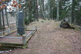 |
The Middle Ages and the beginning of the last century cemetery at the church of Mazirbe. It is surrounded by a moss-covered stone fence. There you can find a number of interesting sights-Werewolf's Tomb, Old Taizelis Tomb, Grand Pine, etc.. |
|
 |
Musteikas pirmsākumi ir meklējami jau 18. gs. Līdz Musteikai no Marcinkones puses var nokļūt pa grantētu ceļu, kas ved gar bijušajiem kolhoza zivju dīķiem. Automašīnu var atstāt ciema sākumā un izstaigāt to ar kājām, izjūtot veco ēku smaržu un šarmu. Musteikā atrodas Dzūkijas biškopības vēsturei veltīts „dzīvs” muzejs, kur stropos dzīvo bites, bet tā saimnieks ir biškopis pēc aicinājuma un būtības. Ja palūgsiet, viņš demonstrēs – kā ar krama, metāla un posas piepes palīdzību senos laikos ieguva uguni. |
|
 |
A straight street which runs through Ķemeri in the northwestern-southeastern direction. The street's name is a proof that it is the former historical boundary between the regions of Vidzeme and Kurzeme. Near the intersection of Robežu and Tukuma streets, you can notice the former pharmacy building-the memory of the former resort of the all-union significance. On the walls there has survived the pharmacy-related symbolism. |
|
 |
One of the most interesting objects in Bigauņciems, the road begins at the seashore, crosses the Vecslocene River (there is no bridge, but hikers and bikers can get across it), and then continues as a forest road to Lake Melnezers. |
|
 |
Vāldamõ – a residential building that is yellow and has natural roofing materials. It was built as a new farm at the beginning of the last century. Virgo is the next homestead to the North from Vāldamõ, and it was established as a new farm in the 1920s. The house (1930) features interesting wood carvings. Next to the North is Fīlmaņi, which has a building that appears antique, but was built in the early 20th century as a single roof. Silkalni is the homestead that we find if we turn to the right toward Pitrags at the crossroads. The yellow building was built around 1906 as a single room. Norpiedagi is to the South from Silkalni – a brown and larger house than the previous one. The home was built around 1906 as a one-room granary by the active Liv public activist and boat builder Diriķis Volganskis (1884-1968). His son, Edgars Valgamā, who was also a Liv cultural activist and worked as a pastor in Finland, was born here. Anduļi can be found at the aforementioned crossroads. This is one of the largest old farms in the village, and it is owned by the village elder. The history of the homestead was first recorded in 1680, when it was called Kūkiņi. The homestead includes a residential building (c. 1909), a threshing barn (1905), a granary (mid-19th century), and a smokehouse made of a boat that was cut in two. Under the part of the threshing barn which is on the back of the dune, there is the medieval, so-called Plague cemetery. Žoki is a homestead that is on the other side of the road from Anduļi. The building that is there now was built on the foundation of an older one. In the mid-19th century, Žoki was home to the first reading school for Liv children from the seashore villages of the Dundaga region. Liv Nika Polmanis (1823-1903) worked there as a teacher. Next to the North of Žoki is the Tilmači homestead, with several buildings that were built in the late 19th and early 20th century – a brown residential building, a stable and part of a granary. When the residential building was restored, the owner found a board reading "1825. Kurlyandskaya gubernya." The seven historical homesteads and buildings were at one time considered for listing on the UNESCO list of world heritage. |
|
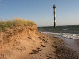 |
Harilaidas galā no jūras ūdens paceļas 26 m augstā Kīpsāres bāka – viena no neparastākajām Igaunijas bākām. Tā celta 1933. g., kad jūra no bākas atradās ~ 100 m attālumā. Krastu noskalošanas rezultātā tā tagad ir viļņu ieskauta. |
|
 |
To the North-west from the Pitrags Baptist church (in the direction of the sea) is a fishing and farming homestead, Kurgati, which was established in the 1930s. This brought new building elements to the Liv Shore – a split roof end which was not typical of buildings in Liv villages. |
|
 |
Temple Hill is steep (with artificially created steepness) and about 30 m high, and it is opposite Marijas Island. It is an ancient Lettigalian castle hill, 80 m long and 40 m wide, with several artificial ramparts. One of the oldest objects found in the region is an axe from the 2nd to 3rd millennium BC. Archaeologists believe that the island was populated at that time. There was a Lettigalian castle on the hill during the 10th and 11th century, but it was sacked by the Holy Crusade. The surface of the castle hill was transformed comparatively recently in 1807, when a granite rotunda was built there in honour of Russian Field Marshall Sheremetev and Swedish captain Wulff. The view of Lake Alūksne and the town is one of the most beautiful ones in all Vidzeme. The Sun Bridge (1937) is also worth a look. A wooden viewing platform is nearby. |
|
 |
The Lašu castle hill is 0.2 km from the Vecumnieki-Ilūkste road at Laši. It is an ancient Selonian castle hill, and it was populated between the 1st millennium BC and the 10th or 12th century. Very little remains of the old Veclaši (Tiesenhausen) Estate, which had an impressive mansion designed in the Neo-Gothic style in the late 19th century. What remains are an ancillary building, the foundations of the mansion, fragments of the gates, and a park. Until 1920, the estate belonged to the Pshezdzetski dynasty, and before that it was owned by the Tiesenhausen and Fittinghoff dynasties. Before visiting the location, look for photographs of the old mansion on the Internet. Sadly, the important cultural monument has not experienced any major improvements over the past 20 years.
|
|
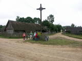 |
Ein der ethnografischen Dörfer in Dzūkija mit Holzgebäuden und Kruzifix. |
|
 |
Vijciema čiekurkalte savu darbību uzsāka 1895. g. pēc plašiem apkārtnes meža ugunsgrēkiem. Šobrīd tā ir vecākā Latvijā un viena no vecākajām Eiropas čiekuru kaltēm. Pēc ceturtdaļgadsimta dīkstāves to atjaunoja 1992. g. Vienreizējais kultūrvēstures piemineklis ir saglabāts pilnīgā darba kārtībā. Ēkā atrodas 19. gs. beigās ražotā autentiskā iekārta un aprīkojums. Arī mūsdienās to izmanto čiekuru žāvēšanai. Ekskursijas laikā apmeklētāji var iepazīties pilnu čiekuru (g.k. – priedes) apstrādes ciklu. Ziemā, kad ir īstais čiekuru žāvēšanas laiks, te demonstrē kaltēšanas procesu. Vijciema čiekurkalte ir iekļauta Eiropas kultūras mantojuma objektu sarakstā. |
|
 |
Salos, Vaišnoriškė, Strazdai, Šuminai sind die bewohnten Dörfe im Augštaitija- Nationalpark, in denen historische Einzelgehöfte mit Holzgebäuden erhalten sind. |
|
|
|
Beliebte und eine der ältesten Straßen in Jurmala zwischen Dzintari und Majori. Die 1,1 km lange Straße mit Wirtshäusern, Sommercafés und Souvenirladen. |
|
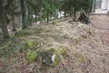 |
A place fraught with many legends and ghost stories about the old burial mound at the church of Mazirbe, an ancient tomb covered by stones– the only known grave of warewolves in Latvia. |
|

