
| No | Name | Description |
|---|---|---|
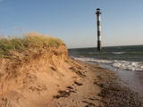 |
Harilaidas galā no jūras ūdens paceļas 26 m augstā Kīpsāres bāka – viena no neparastākajām Igaunijas bākām. Tā celta 1933. g., kad jūra no bākas atradās ~ 100 m attālumā. Krastu noskalošanas rezultātā tā tagad ir viļņu ieskauta. |
|
 |
The Lašu castle hill is 0.2 km from the Vecumnieki-Ilūkste road at Laši. It is an ancient Selonian castle hill, and it was populated between the 1st millennium BC and the 10th or 12th century. Very little remains of the old Veclaši (Tiesenhausen) Estate, which had an impressive mansion designed in the Neo-Gothic style in the late 19th century. What remains are an ancillary building, the foundations of the mansion, fragments of the gates, and a park. Until 1920, the estate belonged to the Pshezdzetski dynasty, and before that it was owned by the Tiesenhausen and Fittinghoff dynasties. Before visiting the location, look for photographs of the old mansion on the Internet. Sadly, the important cultural monument has not experienced any major improvements over the past 20 years.
|
|
 |
Ein zweistöckiges Holzhaus auf dem Uošvės-Hügel mit wunderschönem Blick aufs Haff. Hier hat drei Sommer der Träger des Nobelpreises, deutscher Schriftsteller Thomas Mann (1875 – 1955) verbracht. |
|
 |
Old Believers, who fled persecution from the Russian Orthodox church because of their refusal to adapt to church reforms, settled down on the western shore of Lake Peipsi in the 17th and 18th centuries. |
|
 |
The Apakšceļs road – a lonely, forested and ancient road between
Košrags and Dūmele, with lots of interesting stories about the old Pitragupe
windmill, which never did grind any grain (the foundations are still there), and
about the boiler of a wrecked ship which a local baron used to produce tar.
This used to be a horse path which crossed the Bažas swamp. The great rock
of Dūmele is impressive, indeed.
|
|
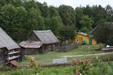 |
Grūti iedomāties, ka vēl joprojām Eiropā ir apdzīvotas vietas, kuru sasniegšanai ir labu laika sprīdi jābrauc pa neapdzīvotu mežu ieskautu smilšainu ceļu, kur tikai paretam var redzēt kādu sēņotāju vai ogotāju! Tāpat kā Zervinos ciemam, arī šim ir piešķirts kultūras mantojuma pieminekļa statuss, jo Linežeris ir viens no dažiem nacionālā parka etnogrāfiskajiem ciemiem. Linežerī ir aplūkojamas 19. – 20. gs. mijā celtās ēkas un apskatāms tā laika ciema plānojums. Šejieniešu tāpat kā citu dzūku galvenā nodarbošanās bija mežistrāde un meža velšu vākšana. Nelielā mērā – arī lauksaimniecība. Apceļojot nacionālā parka etnogrāfiskos ciemus, rodas pamatots jautājums: „Ar ko mūsdienās te nodarbojas cilvēki. Kā viņi spēj dzīvot tik nomaļā vietā”? Jāatzīst, ka lielākā daļa te ierodas tikai vasaras laikā. Neskatoties uz to, etnogrāfiskie ciemi ir ļoti sakopti un joprojām „dzīvi”! |
|
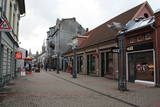 |
Pirmā Liepājas gājēju iela. 140 m garā iela par gājējiem piemērotu tika pārveidota mūzikas festivāla “Mēs Liepājai” (1988. g.) laikā savāktajiem līdzekļiem. Daudzo veikalu un kafejnīcu dēļ iela ir dzīva, tāpēc vietējo iedzīvotāju un viesu iecienīta. |
|
 |
A haven for Russian Old Believers. Mustvee village has held fairs for the past two centuries. It is also a traditional fishing town. |
|
 |
Atrodas Tērvetē, Dobeles – Elejas ceļa malā, 0,2 km dienvidrietumos no Tērvetes pilskalna. Ar mežu apaugušais paugurs ir sena apmetnes vieta, kas bijusi apdzīvota jau 1. g.t. pr. Kr. Teika stāsta, ka kalnā bijis klosteris, kura mūki pēc klusēšanas pārkāpuma saulgriežu laikā kopā ar visu celtni nogrimuši kalna dzīlēs. |
|
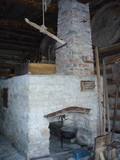 |
In Metsanurme Village Centre you can see restored old threshing barn, limestone barn oven and few tools that were used ages ago. You could be also interested in seeing an outdoor exhibition which focuses on historical agricultural tools. All of this is made to look interesting to not only locals but also visitors. |
|
|
|
The Cemetery of the Brethren of
Lāčukrogs offers a final resting place to
men who fell during World War I.
|
|
 |
This partly forested hillock stands 40 metres above the surrounding area and offers impressive views. The fact that this was once a castle hill is attested by the presence of a moat and remnants of defensive fortifications. It is thought that Lettigalian tribes settled here in the 10th century AD. You can climb the hillock to take a look at the surrounding landscapes. |
|
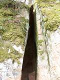 |
The Vējupīte ravine is meant for those who are not afraid of long and steep wooden stairs of the type that lead you up and down the ravine. From the Līvkalns guesthouse, you can climb the stairs downward, where you will find a shallow (3.6 m) but high (6.1 m) cave – the Pēters Cave. It is something of a gap or a niche. Another 10 minutes or so downstream (toward the Gauja) will lead you to the deep Pūces ravine and its Kraukļupīte River. The Satezele castle hill is at the confluence of the two rivers (90 x 75 m). A wooden castle was there during the feudal era in the early 13th century. Its main entrance was on the western side of the castle hill. You can get to the hill from the depths of the ravine via a wooden staircase. The Kraukļi ravine, in turn, is accessible if you climb down the same stairs and continue on your way toward the Gauja. The ravine is found on the left bank of the Vējupīte, and its sandstone walls are up to 11 m high. The Kraukļi cave, which is 5.2 m deep, is on the wall. Another 10-15 minutes (crossing the Vējupīte on a wooden bridge), and you will find another staircase leading you to Paradīze Hill (see the description above). |
|
 |
Near Mākoņkalns hill there is a trail that is mowed in the summer and leads to several historical rocks – Plakanais (Flat) rock, Āža muguras (Ram's Back) rock (on which you can clamber), and the Jaunstašuļi Velna pēdas (Devil's Footprint) rock, on the surface of which is a shape similar to a human footprint. There are signs along the side of the road leading to the trail. |
|
 |
Atrodas 0,3 km ziemeļos no Vecpiebalgas pilsdrupām. Ap 10 m augsto, bet visnotaļ izteiksmīgo Grišku kalnu sauc arī par Piebalgas, Balgas un Veļķu pilskalnu. 13. gs. šeit bijusi svarīga apmetnes vieta ar mākslīgi nostāvinātām nogāzēm un dziļu aizsarggrāvi. Vēstures notikumi ir atstājuši ap metru biezu kultūrslāni. Bezlapu laikā no kalna paveras skats uz Vecpiebalgas baznīcu un pilsdrupu vietu. Pilskalna piekājē ir aka ar Griškavotu. |
|
 |
Swedish scanst (Kuce Hill, Jumprava Hill). Medieval fortification. The monument of national meaning
is located in the village Stari 450 m from Atspuki mill, 70 mto the Southeast from the ruins of Jumpravmuiža.
The territory is 0,7 – 1 m deep outside and 1 – 1,5 m high inside. The new road to the ruins of Jumpravmuiža
leads through the West side of the fortification.
|
|
 |
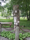
Marking of the Jānis Lībietis Alley in the
Ķemeri Park – Lībietis directed the institution
which managed the Ķemeri sulphurous springs
from 1928 until 1944, and the monument to
him is at the end of the Jānis Lībietis Pathway
|
|
 |
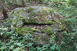
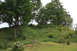
Stupeļu Hill is 3 km to the South of the Vecumnieki-Ilūkste road. There are no signs, so the castle hill might be difficult to find. The Great Stupeļu Rock, which is discussed further on in this guidebook, is also hard to find when there is vegetation. Stupeļu Hill is approximately 30 m high, and it was one of the highest castle hills in the historical district of Selonia. Archaeologists say that it was first abandoned at the beginning of our era and then populated again during the late Iron Age. It is interesting that iron was extracted and processed near the castle hill. Archaeologists believe that this is the site of one of the earliest “cities” in the region. To the West of the hill is the Great Stupeļu Rock, which is 6.7 m long, 5.6 m wide and up to 2.7 m high. Above ground, it is 35 m3 large, and it may have been a cult location. During archaeological digs in the late 1970s, antiquities from the 10th to the 13th century were found here. |
|
 |
The site of the Oak tree of love, which was
once a symbol of the growth of Ķemeri on the
left bank of the Vēršupīte.
|
|
 |
Neliela apdzīvota un ainaviska vieta plašajā Skrobļa (Skroblus) strauta ielejā. Ciema austrumu pusē atrodas Lietuvas mērogā unikāls objekts – klēts - rija, kur no 1929. g. vietējie cilvēki uzveda un skatījās lauku teātra izrādes. Netālu no tās (uz abiem objektiem ir norādes) atrodas Skrobļa avoti (Skroblaus versmės), kas iztek no dziļas starppauguru ieplakas. Avotu gan ir appludinājis bebru uzceltais dambis. Dienvidos no ciema atrodas vecs grants karjers, kas ir viena no retajām vietām Baltijā, kur dabā ir atrodami krama ieža gabali, kas atnesti ar ledāju. |
|
