
| No | Name | Description |
|---|---|---|
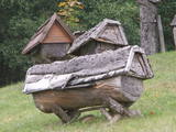 |
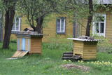
Das bekannteste Museum der Geschichte der Bienenzucht Litauens mit den Bienenhäusern verschidener Arte, der Arbeitsmittel der Bienenzüchter, Holzskulpturen und Hönigankauf. |
|
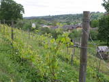 |
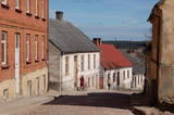
Already in the 10th century, an ancient village was located at the Sabile hill fort. After the division of Course land, Sabile was won by the Livonian Order, which built a stone castle (not preserved) here. Sabile is first time mentioned in written sources in 1253. During the 15th century an urban area started to develop at the castle. Town right was awarded to Sabile in 1917. Today Sabile is a small town, surrounded by many notable monuments. Roma culture is an integral part of Sabile and therefore, Sabile is also known as the Latvian capital city of Roma. Sabile has long been known for its wine-growing and oenological traditions, which have been reborn and enjoyable during the Sabile wine festival. |
|
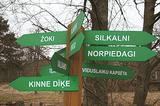 |
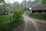
is seen as the newest village along the Livonian coastline. It was established during the 17th century. Košrags had 78 residents in 1826. The first reading school for Livonian children in the Dundaga seashore villages was opened at the Žoki homestead in 1832. One of the teachers was Nika Polmanis, who was the first Livonian to have completed a professional education. He also translated the Gospel of Matthew into the Eastern Livonian dialect. Košrags had a windmill, water mill and boat building facility. During the spring, job seekers from Saaremaa stopped here. A port was installed in 1932, and a breakwater to collect sea fertiliser followed in 1938. During the 1930s, Košrags was regularly visited by Finnish and Estonian linguists to study the folklore of the Livonians. The Norpiedagi homestead was built by Livonian activist Didriķis Volganskis (1884-1968). His son, Livonian cultural worker and pastor (in Finland) Edgars Vālgamā (Volganskis, 1912-2003) was born there. He translated the Andrejs Pumpurs epic "Lāčplēsis" into Finnish. Košrags today is a cultural monument of national importance. |
|
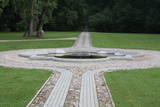 |
A small settlement on the banks of the River Daugava, between Aizkraukle and Jaunjelgava. Skriveru region is associated with the life and work of popular Latvian author A. Upitis. Near Skriveri lies the oldest arboretum in Latvia. Its establishment in 1891 was started by the owner of Skriveru manor Maximilian von Siverss. In the park there are about 400 plant species, varieties and forms. One of the finest views of the Daugava will open from the so-called Krauklu Mountains – steep upper part of the right riverbank, which is an ancient hill fort. |
|
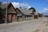 |
The wooden buildings with few floors emerged in the 19th century. Tourists can look at typical closed yards, verandas, wooden elements and decorations. The city suffered from fires in 1866 and 1938. The Market Square is the historical centre of Ludza, while the Ludza castle hill dominates the region. The streets of the city were established around the hill, which had an ancient Lettigalian wooden castle late in the 14th century. The Livonian Order replaced with the mightiest brick castle in Latgale. It was sacked in 1654 by the forces of Tsar Alexei Mikhailovich. The castle hill offers a lovely view of Latgale and the oldest city in Latvia and its historical centre. |
|
 |
Ein einzigartiges Örtchen beiderseits des Flusses Minija, wo der Fluss eine „Hauptstraße” ist. Litauens Venedig. |
|
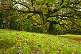 |
was first mentioned in written form in 1582. A census in 1736 found two farms, Lekši and Žonaki. A census in 1935 found that there were 106 people in Vaide, including 40 Livonians, 60 Latvians and a few Estonians and Germans. In 1939, there were 21 homesteads in the village. Nika Polmanis (1823-1903) was born at the Lāži homestead. He was the first educated Livonian and lived in the region for all his life. Livonian poet Alfons Bertholds (1910-1993) wrote a poem about a noble oak tree that grows alongside the homestead. The vast Berthold family is linked to Žonaki -- Livonian storyteller Marija Šaltjāre, yacht captain Andrejs Bertholds (USA), his son, library scholar Artūrs Benedikts Bertholds (USA), Livonian poet Alfons Bertholds, Livonian language specialists Paulīne Kļaviņa and Viktors Bertholds, Swiss doctor Marsels Bertholds, globally renowned pianist Arturs Ozoliņš (Canada), and Livonian language storyteller and poet Grizelda Kristiņa (1910-2013), who was the last native speaker of Livonian. The Ozolnieki homestead is also linked to the Bertholds family. Paulīne Kļaviņa (1918-2001), a specialist in the fields of Livonian traditions and language, and her mother, Livonian storyteller Katrīna Zēberga, both lived there. Paulīne collected ethnographic objects that can be seen at the Latvian Ethnographic Open Air Museum in the granary of the Livonian Dēliņi farm. The Purvziedi homestead in Vaide is owned by forest ranger Edgars Hausmanis, who has a collection of forest animal horns and antlers. |
|
 |
Until 13th century, Smiltene region was a part of Talava country, inhabited by Latgalians. After Crusaders invasion it was won by the Archbishop of Riga, and he built a stone castle on the steep river bank of Abuls in 1370. The following wars and epidemics did not spare the development of settlement, nor the people. Present shape of the town began to emerge in 19th century along with the vigorous activities of owner of Smiltene manor first Lieven. Until the World War I, wood working factory, hydroelectric power plant (established in 1901, first in the Baltics), and other companies were operating in Smiltene. In 1944 when the German forces retreated, much of the Smiltene historical buildings were destroyed in the fire. |
|
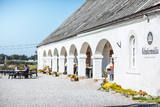 |
Located in the northern part of Valmiera, the Valmiermuiža Estate mansion (Neo-Baroque Style) was built between 1764 and 1771 by Prince August Friedrich of Schleswig, Holstein and Soderburg. Over the course of time it has been owned by other people. According to modern evidence, the mansion was a one-story building with a Baroque tower and a two-story addition in the early 20th century, which made it appropriate as a summer home and hunting lodge. The building burned down in 1918. Two years later, Valmiermuiža became a prison camp for captured soldiers. Later the addition to the mansion was restored and used as an elementary school. In 1936, the building became a prison, and it was once again a prison camp for captured soldiers during World War II. Later the building burned down again, and the ruins were removed. Still surviving is the Valmiermuiža tower, with ceiling paintings that are a cultural monument, as is the surrounding park. The Valmiermuiža brewery is alongside the historical monument, thus providing second wind for the whole region. |
|
 |
Ja mērķis ir savākt pilnvērtīgu etnogrāfisko ciemu fotokolekciju, ir jāapskata Strazdi (no lietuviešu valodas strazdai tulkojumā nozīmē strazds), kas ir pavisam neliela apdzīvota vieta Balošas (Baluošas) ezera ziemeļu krastā. Strazdi pirmoreiz rakstos minēti 1783. g. un ciema nosaukums cēlies no kādas mežziņu dzimtas uzvārda. |
|
 |
The Slutiški village is a very ethnographic village with a layout and buildings typical of the Latgale region, complete with decorated windows and facades. The Slutiški Old Believers House features a museum focusing on the cultural environment and traditions of the Old Believers. One of Latvia’s most unusual landscapes can be seen from the ancient banks of the Daugava River. |
|
 |
This is an ancient populated area. There were 50 homesteads here during the 1930s, with only ten remaining in 1990. The Livonian scholar and entomologist Kārlis Princis (1893-1978) was born in Oviši. In 1944, he emigrated to Sweden. The Oviši lighthouse (1814) is 38 metres high and is the oldest functioning lighthouse in Latvia. There are lovely views from the top of the lighthouse. The building in which employees of the lighthouse used to live was erected in 1905 and has been preserved. A narrow-gauge train station was in the building at one time. The Oviši Lighthouse Museum is nearby, as is the metal Tree of Austra. Opposite Cape Oviši is a great place for bird watching. |
|
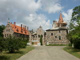 |
Cesvaine was first mentioned in written sources in 1209. For each traveller in Latvia, the town is associated with the family of Baron Woolf, who bought the Cesvaine estate in 1815. Cesvaine experienced the economic boom after establishment of Plavinas Gulbene railway. Town suffered significantly during the World War II. At the end of 2002, the Cesvaine Castle was struck by the tragedy - a fire, which damaged most of the castle. Cesvaine Castle is "recovering" by means of large public, state and local government support and still keeps the status as a significant tourism attraction in a scale of Vidzeme and Latvia. |
|
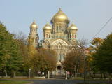 |
The city of wind, amber and musicians. In the literature sources Liepaja was mentioned for the first time in 1253. The city strived as a trade harbour already at the end of the 16th century. Especially important was the ruling period of Kurzeme Dukes Jacob and Friedrich, when the export and import of Lithuania and Kurzeme goods was provided through Liepaja harbour. Instead of the Līva River that was filled with dune sand a channel was excavated and wharf was formed. The growth of the city continued in the 18th century also after the Northern War and the plague epidemic. When in 1795 Kurzeme was added to the Russian Empire, as one of the most important western harbours of the Empire the harbour of Liepaja developed even more rapidly. From the end of the 18th century until the 19th century Liepaja also became a popular recreation place for the aristocrats of Petersburg. At the end of the 19th century the construction works of War Port and fortress begun. The city became a military strategic place. It suffered hard during World War II. In 1967 the sea trade harbour terminated its operation in Liepaja and Liepaja became a closed city where the War Port was "a city within a city". Today the War Port and its offer is one of the top tourism spots in Latvia. |
|
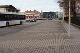 |
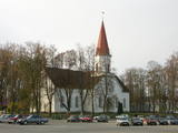
Ap 200 m garajā un izstieptās formas laukumā no 16. – 20. gs. atradās Liepājas tirgus. Laukuma malās tolaik bija izveidojusies vienstāvu apbūve – iebraucamās sētas, viesnīcas un dārzi. Līdz ar Pētertirgus izveidi 1910. gadā, izmainījās arī laukuma apveidi un to ieskaujošā apbūve. Laukuma DA malā slejas iespaidīgā Liepājas Svētās Annas Luterāņu baznīca. |
|
 |
It is believed that at the Kezberkalnins of Limbazi has been Lemisele castle of Metsepole Liv district. It is also found in the reports that merchants travelled to this place from the sea by Svētupe and Dunezers until the 16th century. In 1223 Bishop Albert built a stone castle in Limbazi. Like Valmiera, Limbazi became the member of Hanseatic League. At the beginning of 16th century it economic role declined significantly since Svētupe and Dunezers became unusable for shipping. Between the 16th and 18th centuries, the town and its people suffered from wars, diseases and fires. As a result, the population reached its utmost fall - eight people. In the turn of 19th and 20th century and in the beginning of 20th century the economic life of the town was renewed. |
|
 |
Liela meža masīva vidū gleznainās Būkas (Būka) upes krastos starp kokiem ieslēpies teiksmainais Vaišnoriškes ciems. Šis ir viens no skaistākajiem nacionālā parka etnogrāfiskajiem ciemiem. Vaišnoriške kā apdzīvota vieta sākusi veidoties 1756. g., kad šeit sena vēsturiska ceļa malā darbojies krogs. Pirmā viensēta ciematā ir zināma no 1830. g. Šodien redzamā apbūve ir tapusi g.k. 20. gs. sākumā. Ciems ir palicis cilvēku atmiņās ar liepu medu, jo meža velšu vākšana un biškopība bija viena no galvenajām šejieniešu nodarbēm. Tagad ciemā ir piecas sētas. No Vaišnoriškes var uzsākt laivu braucienu pa seklo un dzidro Būku. |
|
 |
Kandava is first mentioned in the articles in 1230. In 1253 the Livonian Order built a stone castle at the upper part of Abava valley shore, at the foot which of an urban area formed. In the 17th century Kandava became an important trading centre. The plague epidemic and developments of World War I hit the town and its people hard. Kandava got the town rights in 1917. During soviet Soviet times, Sports Complex of Jaunkandavas agricultural Technical School became a popular training venue. |
|
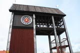 |
Tāpat kā Ventspils Rātslaukums, arī Tirgus laukums ir uzskatāms par pilsētas vēsturiskā centra nozīmīgu daļu, kura apkaimē ir saglabājies senais ielu plānojums. Kādreizējā Rātsnama vietā tagad slejas kariljonu zvana pulksteņu tornis. Tas zvana katru stundu, bet 12:33:44 un 00:33:44 ar īpašu melodiju ieskandina astronomisko Ventspils laiku. Tirgus laukumā ir aka, kas saulainā laikā darbojas arī kā Saules pulkstenis. Monētu automātā var izkalt īpašu piemiņas monētu. |
|
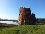 |
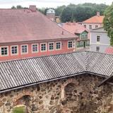
Piltene is one of the smallest and oldest cities in Latvia, first mentioned in 1295, and being granted the rights of a city in 1557. Between the 14th and 16th century, Piltene was the administrative centre for the Bishopric of Kurzeme. The historical streets that surround the castle ruins feature wooden buildings from the first half of the 19th century. The bishop’s castle in Piltene was built at the turn of the 14th century and used until the 16th century. Only its foundations and fragments of its tower on the banks of the Vecventa River survive. |
|
