
| No | Name | Description |
|---|---|---|
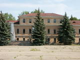 |
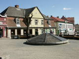
1275 is considered as a year of foundation of Daugavpils. This is the time when the Master of Livonian Order Ernst von Ratceburgs built Dinaburg castle at the Naujene hill fort. It suffered several Lithuanian and Russian invasion until in 1577 the castle was destroyed by Russian troops under the command of Ivan the Terrible. After this event Dinaburg was restored 17 km further on the right bank of the river, where now the town of Daugavpils is located. From 1810-1833a new fortress was built. In 1826 started the building of what is now the historic centre of the town. During the World War I the major industrial companies with workers were evacuated to Russia. During first Latvian Republic, the cultural life in Daugavpils flourished. Most part of the town was destroyed during World War II – in the July of 1944. Nowadays the town is the second largest town in Latvia and is an important economical centre of Latgale historic region. Restoration of Daugavpils Fortress was launched recently; this project can be considered as a unique on the European scale. |
|
 |
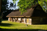
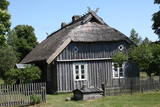
This village is at the place where the Irbe (Dižirve, Īra) River flows into the sea, and it is on both shores of the river (sea side and land side). The name of Irbe was recorded for the first time in a 1310 border agreement between the bishop of Kurzeme and the Rīga Dome Capitol. The name of Lielirbe (Irvemūnde) was recorded for the first time in a document from an arbitration court in 1387. At the end of the 19th century, the small port at Lielirbe was an active centre for the sale and transport of timber materials. In the late 19th and early 20th centuries, the largest number of sailing ships among villages on the western shore of Kurzeme was built there. In 1939, the village had some 300 residents, more than 70 houses and a Baptist church which is now at the Ventspils Open Air Museum. A narrow-gauge railroad passed through the village, which had a post and telegraph office, two grocery stores, an elementary school, a choir and a brass band. Lielirbe was one of the largest villages to disappear after World War II. Cultural historian Valda Marija Šuvcāne (1923-2007) was born in Lielirbe, and her daughter, Baiba Šuvcāne, is continuing her mother's work by writing important papers about life along the Livonian coastline. By 2019, a bridge is to be reinstalled across the Irbe River. |
|
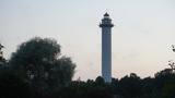 |
(formerly Pize and Pizā in Livonian). The current name of the village comes from a lighthouse (Mihailovskii majak) that was built during the age of the Russian Empire and named for the nephew of Tsar Alexander II. The lighthouse that is there now is the third one to be built on the site. It was built in 1957 and is the highest lighthouse in Latvia (57 m, can only be viewed from the outside). The Lutheran church in Mikeļtornis was built in 1893, and nearby is the Pize Saloon (1857), which is terrible condition. The saloon has a typical design from the 19th century and is the only venue of its type on the Livonian coastline. The first Livonian cultural activist, Jānis Princis (1796-1868), was born in Miķeļtornis, and he and son Jānis translated the Gospel of Matthew into the Western Livonian language. The two of them also wrote a collection of poetry, "Holy Songs and Prayers for Sailors." The only poetry book in Latvia prior to that was published by Blind Indriķis. A student of Vilhelms Purvītis, Livonian painter Andrejs Šulcs (1910-2006), was born at the Olmaņi homestead in Miķeļtornis. A monument to Livonian poets was installed at the local cemetery in 1978 and was the first monument dedicated to Livonians. There are plans to open an environmental object by artist Ģirts Burvis, "Century of Sailing Ships", in 2019. |
|
 |
This is an ancient Liv village, known as Mustanumm is the last village in the south-easterly direction, and during the mid-20th century, just a few Livonians lived there. Of 307 inhabitants in 1935, only 15 were Livonians. At the beginning of the 19th century, there were six farms and a lagoon here, but at the end of the century there were 63 farms. The valley of the Baķupīte River and the sea had remnants of pilings that provided evidence about a Medieval port. Legends say that the sea robber Trommel had a castle on the left bank of the river during the 14th century. Sailing ships were once built in the region, as well. Two locations of cultural and historical importance in Melnsils are the ancient cult location that is the Baķi castle hill, and the castle hill of a sea pirate Trommel. |
|
 |
Third biggest island in Estonia. Full of beautiful grown junipers, little dolomite outcrop on the coast of the sea and fishermen villages on the coastline. |
|
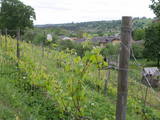 |
Already in the 10th century, an ancient village was located at the Sabile hill fort. After the division of Course land, Sabile was won by the Livonian Order, which built a stone castle (not preserved) here. Sabile is first time mentioned in written sources in 1253. During the 15th century an urban area started to develop at the castle. Town right was awarded to Sabile in 1917. Today Sabile is a small town, surrounded by many notable monuments. Roma culture is an integral part of Sabile and therefore, Sabile is also known as the Latvian capital city of Roma. Sabile has long been known for its wine-growing and oenological traditions, which have been reborn and enjoyable during the Sabile wine festival. |
|
 |
Die zentrale und auch schönste Straße in Trakai mit bunten Holzhäusern. Eins der seltenen Kenesa-Gebetshäuser der Welt – ein eingeschossiges Holzhaus mit einem bläulichen Dach. |
|
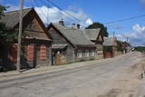 |
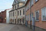
The wooden buildings with few floors emerged in the 19th century. Tourists can look at typical closed yards, verandas, wooden elements and decorations. The city suffered from fires in 1866 and 1938. The Market Square is the historical centre of Ludza, while the Ludza castle hill dominates the region. The streets of the city were established around the hill, which had an ancient Lettigalian wooden castle late in the 14th century. The Livonian Order replaced with the mightiest brick castle in Latgale. It was sacked in 1654 by the forces of Tsar Alexei Mikhailovich. The castle hill offers a lovely view of Latgale and the oldest city in Latvia and its historical centre. |
|
|
|
Pilsētā nebija lielu rūpniecības uzņēmumu, un tās iedzīvotāji
nodarbojās galvenokārt ar amatniecību, tirdzniecību un lauksaimniecību.
Ilūkste tika pilnībā nopostīta 1. pasaules kara laikā un smagi cieta arī
2. pasaules kara laikā. Šodien Ilūkste ir klusa pierobežas mazpilsēta, ko
ieskauj gleznains dabas apvidus. Apskates objekti: bijušā jezuītu klostera ēka
un Ilūkstes katoļu baznīca.
|
|
 |
Haapsalu was once loved by aristocrats who stayed here during summers, nowadays this town is very appealing to its visitors because of its essence - tiny streets, old wooden buildings and promenade. Worth mentioning are also town's SPAs which were one of the reasons why Haapsalu was so popular its earlier years. Interesting enough, the famous composer Tchaikovsky considered this place one of his favorite's for spending the holidays. |
|
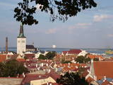 |
The capital of Estonia. The Old Town of Tallinn - excellent medieval (14.-15th century) building monument. The former city of Hanza. |
|
 |
Origins of Livani as a bigger place of population are linked to the 1533, when the then owner of the land Lieven established the manor and called it after his own name Lievenhof. The 1678, the first Catholic Church was built here. The city suffered considerably during the two world wars. Name of Livani is associated with the glass. In 1887 a glass factory was founded here, which today has ceased operation. |
|
 |
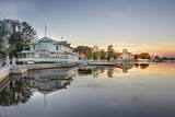
The largest town in the region dates back to the 19th century, when three local fishing villages – Neibāde, Pēterupe and Katrīnbāde – became a popular location for leisure and swimming. This led to the construction of many summer homes, and the development of the spa was facilitated by the opening of a rail line between Rīga and Saulkrasti in 1905. New spas and restaurants were opened, and the spa infrastructure was developed. During the summer there were various entertainments, including balls and concerts featuring orchestras from Rīga. Also facilitating the development of the spa was a road and railroad line between Rīga and Saulkrasti that were installed during the 1930s. During the Soviet occupation, leisure homes, sanatoriums and new summer homes were built in Saulkrasti, which was given the status of a city. Today Saulkrasti is attractive because of its white sand beach, as well as various annual events, the Saulriets trail, the White Dune, the unique bicycle museum, Sea Park, the “Centrs” swimming facility, Sun Square, etc. |
|
|
|
The town's name in historical sources was first mentioned in 1224. In 1340 Archbishop of Riga built a stone castle at the Latgalian hill fort (now - the Lutheran Church). In 1802 (owned until 1920) Vecgulbene estate was bought by Baron G. Wolf. Manors in the surroundings of Gulbene and Vecgulbene castle substantially suffered during the Revolution in 1905 and in the further historical events. Today, there is a substantial change in the landscape, especially in the area of White Castle, where a large-scale restoration works occurred in recent years. Either way, - Gulbene is the place worth visit to get new impressions and knowledge. |
|
 |
Aizputes pilsdrupas, akmens tilts pār Tebru, Jaunā pilsmuiža, ūdensdzirnavas un Sv. Jāņa luterāņu baznīca, kā arī 19. gs. beigās celtās koka ēkas starp Jāņa, Katoļu un Atmodas ielu veido neparastu pilsētbūvniecības kompleksu, kam piešķirts kultūras pieminekļa statuss. Staigājot pa vēsturisko centru, uzmanība jāpievērš ēku durvīm un to vērtnēm, logu ailēm, balkonu margām u.c. elementiem. |
|
 |
Tukums in the historical sources is mentioned in 1253 agreement of the Livonian Order and the Bishop on the division of Kursa. If the town's name is translated from the Liv language, it means "a pile, mountains of sand". at the beginning of 14th century German merchants and craftsmen settlement was formed at the Livonian Order stone castle, whose flowering was facilitated by the proximity of Riga - Prussian road. Later the city was largely influenced by the construction of Riga - Tukums railway in1877. During the Soviet period the on the eastern outskirts of Tukums, the largest Soviet military airfield and military town in the Baltic States was deployed. Today Tukums is a district centre of the same name with a wide range of services offered to tourists. |
|
 |
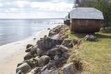
Koņuciems of Pape is one of the few seashore fishing villages in Latvia to have preserved an authentic environment to the present day. The Latvian Open-Air Ethnographic Museum has a branch here, “Vītolnieki”, and this is an authentic and ancient fisherman’s farm. +371-2926-2283. The sad fact is that some people have built modern buildings in the village, and it has now lost its earlier untouched charm. |
|
 |
Madona is probably the only town in Latvia, in whose area a lake settlement was located around the 9th century. Its residues are preserved in the northern part of Salas Lake (Baznicezers) under water. Until the end of 19th century, a small estate with the same name (Madona) was located in place, where present town is located, Latvians called the place Bizi. In 1898 construction of narrow gauge railway between Stukmani (Plavinas) and Valka was started. The development of railway helped the development of the town. Today Madona is well maintained Vidzeme town with its own charm typical for small town. Interestingly that it can also be considered as one of the most highly placed towns in relief of Latvia. |
|
 |
Jaunpils development is linked to the Livonian Order's castle, which until now has hardly changed its building volume and appearance. From 1561 until 1919 it belonged to the barons Reki family. In 1905 the castle was burned down, but later it was reconstructed under the supervision of architect V. Bockslaff. Substantial castle restoration work began during the sixties of 20th century. Now in the castle is a museum, but gourmets can taste medieval dishes at the castle tavern. |
|
 |
Ja mērķis ir savākt pilnvērtīgu etnogrāfisko ciemu fotokolekciju, ir jāapskata Strazdi (no lietuviešu valodas strazdai tulkojumā nozīmē strazds), kas ir pavisam neliela apdzīvota vieta Balošas (Baluošas) ezera ziemeļu krastā. Strazdi pirmoreiz rakstos minēti 1783. g. un ciema nosaukums cēlies no kādas mežziņu dzimtas uzvārda. |
|
