
| No | Name | Description |
|---|---|---|
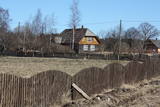 |
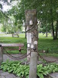
To the North-west from the Pitrags Baptist church (in the direction of the sea) is a fishing and farming homestead, Kurgati, which was established in the 1930s. This brought new building elements to the Liv Shore – a split roof end which was not typical of buildings in Liv villages. |
|
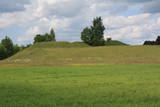 |
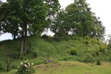
This is one of comparatively few castle hills along the banks of the Daugava River that is not overgrown with trees and bushes, which means that it has a classical castle hill form that is part of the local landscape. The Dignāja castle hill was settled during several periods, particularly between the 5th and the 9th century AD, when it was an important centre. Archaeologists have found that Lettigalian tribes lived here. After the Holy Crusade invasion, the Livonian Order built a castle on the hill that has not survived. It is said that there was once an underground passageway under the hill. The hill itself offers a lovely view of the Daugava River valley. World War I trenches have been preserved the area. There was once a settlement at the foot of the hill. |
|
 |
Salos, Vaišnoriškė, Strazdai, Šuminai sind die bewohnten Dörfe im Augštaitija- Nationalpark, in denen historische Einzelgehöfte mit Holzgebäuden erhalten sind. |
|
 |
The Narūta River which flows out of Lake Ežezers is approximately 1 km long and ends at the small Obiteļi windmill lake. On the right bank of the river is a windmill that was built around 1900. Today the site has the Obiteļa leisure centre with a sauna and banquet facilities. |
|
 |
The site of the Oak tree of love, which was
once a symbol of the growth of Ķemeri on the
left bank of the Vēršupīte.
|
|
 |
Atrodas Tērvetē, Dobeles – Elejas ceļa malā, 0,2 km dienvidrietumos no Tērvetes pilskalna. Ar mežu apaugušais paugurs ir sena apmetnes vieta, kas bijusi apdzīvota jau 1. g.t. pr. Kr. Teika stāsta, ka kalnā bijis klosteris, kura mūki pēc klusēšanas pārkāpuma saulgriežu laikā kopā ar visu celtni nogrimuši kalna dzīlēs. |
|
 |
Atrodas 0,3 km ziemeļos no Vecpiebalgas pilsdrupām. Ap 10 m augsto, bet visnotaļ izteiksmīgo Grišku kalnu sauc arī par Piebalgas, Balgas un Veļķu pilskalnu. 13. gs. šeit bijusi svarīga apmetnes vieta ar mākslīgi nostāvinātām nogāzēm un dziļu aizsarggrāvi. Vēstures notikumi ir atstājuši ap metru biezu kultūrslāni. Bezlapu laikā no kalna paveras skats uz Vecpiebalgas baznīcu un pilsdrupu vietu. Pilskalna piekājē ir aka ar Griškavotu. |
|
 |
One of the most interesting objects in Bigauņciems, the road begins at the seashore, crosses the Vecslocene River (there is no bridge, but hikers and bikers can get across it), and then continues as a forest road to Lake Melnezers. |
|
 |
The remnants of the Vardīte sulphurous
spring – not easy to find, but the location is
between the Forest House and the Ķemeri
Hotel.
|
|
 |
Around 6 km in length and an isolated route stretching between Ragaciems and Klapkalnciems where, as stories about olden days tell, robbers used to attack travelers. Around 1.5 km before Klapkalnciems (going from the side of Ragaciems), in the dune by the sea there is installed a commemorational stone dedicated to the Finnish jaeger battles. It was installed on December 09, 1997. The stone has "travelled" from the south-eastern part of Finland where in 1940 it served as an anti-tank defense. In the monument, there are engraved the words, "Here during World War I, from August 1916 to December fought the Finnish yeagers". In turn, in Klapkalnciems there is installed a commemorational stone in the place where there are buried five Finnish soldiers. |
|
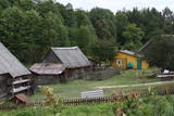 |
Grūti iedomāties, ka vēl joprojām Eiropā ir apdzīvotas vietas, kuru sasniegšanai ir labu laika sprīdi jābrauc pa neapdzīvotu mežu ieskautu smilšainu ceļu, kur tikai paretam var redzēt kādu sēņotāju vai ogotāju! Tāpat kā Zervinos ciemam, arī šim ir piešķirts kultūras mantojuma pieminekļa statuss, jo Linežeris ir viens no dažiem nacionālā parka etnogrāfiskajiem ciemiem. Linežerī ir aplūkojamas 19. – 20. gs. mijā celtās ēkas un apskatāms tā laika ciema plānojums. Šejieniešu tāpat kā citu dzūku galvenā nodarbošanās bija mežistrāde un meža velšu vākšana. Nelielā mērā – arī lauksaimniecība. Apceļojot nacionālā parka etnogrāfiskos ciemus, rodas pamatots jautājums: „Ar ko mūsdienās te nodarbojas cilvēki. Kā viņi spēj dzīvot tik nomaļā vietā”? Jāatzīst, ka lielākā daļa te ierodas tikai vasaras laikā. Neskatoties uz to, etnogrāfiskie ciemi ir ļoti sakopti un joprojām „dzīvi”! |
|
 |
Svētkalnā atradusies krustnešu nocietinātā pils. Zemgaļiem to nebija pa spēkam ieņemt, tādēļ, nodedzinādami savu pili Tērvetes pilskalnā (1286. g.), tie aizgāja uz Raktes (Žagares) novadu Lietuvā. Kad Svētkalna nocietinājumi bija zaudējusi savu militāro nozīmi, krustneši to nojauca. 1701. g. Ziemeļu kara laikā Svētkalnā atradās zviedru armijas nocietinātā apmetne, no kā arī cēlies vietvārds. Domājams, ka pirms tam šajā vietā atradusies seno zemgaļu svētvieta. No Svētkalna paveras viena no skaistākajām un biežāk fotografētajām Tērvetes ainavām. |
|
 |
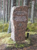
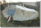
The Strūves Park is toward the northwest of Jēkabpils, on the left bank of the Daugava, and opposite the Ādamsona (Krustpils) island. The park was established in the 19th century as a place where the city’s residents could relax and hold celebrations. It can be said with absolute certainty that this is a place of global importance, because the park contains a memorial stone to Professor Friedrich Georg Wilhelm Struwe (1793-1864) from the University of Tartu. He was an astronomer and geodesist. The stone is at a place where Struwe completed his land survey of the Vidzeme Province of the Russian Empire. The meridian location which Struwe identified (and other points related to those locations are found in many other European countries) is on the UNESCO list of world heritage. |
|
 |
The memorial stone to Augusts Muižulis,a recipient of the Lāčplēsis Military Order, is placed in the Lapmežciems, at the edge of the road (P 128, Jūrmala-Talsi) at the marker for the 9th kilometre. A. Muižulis, (189 –1941) was a lieutenant colonel in the No. 4 Valmiera Infantry Brigade. The adjacent Tuteņi homestead is his native home. |
|
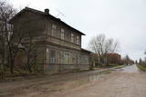 |
Taisnā Celtnieku iela ir bijušās Liepājas – Aizputes šaursliežu dzelzceļa (celta 1900. gadā, 49 km gara) līnijas „trase”, kuras malā (Celtnieku ielā 50) redzama bijusī dzelzceļa stacijas ēka. |
|
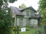 |
This is the one street in Ķemeri where the towns' wooden buildings have been preserved to the greatest degree. Turning onto Durbes Street from Karogu Street, you will find the Miervaldis Ķemers Museum, which is focused on the well known Latvian cultural activist, pastor and painter (1902-1980). The museum is at Durbes Street 21. |
|
 |
Ičas apmetnes ciems ir sena dzīvesvieta Ičas upes krastos. Apmetne atklāta 1937. gadā. Tā bijusi apdzīvota neolītā (4500 - 1500 pr.Kr.) un bronzas laikmetā (1500 - 500 pr.Kr.). Apmetnē dzīvojuši amatnieki, zvejnieki, mednieki.
|
|
 |
Die Straße führt durch die ehemaligen Fischerdörfer. Eine bessere Radfahr-Alternative auf der Strecke zwischen Häädemeeste und Ainaži. |
|
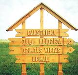 |
„Upmaļi” is the family house of writer Janis Klīdzējs who has written 8 novels, 11 storybooks, 2 essay books
and reflections about Latgalian catholic-Latvian mentality. Janis Streičs (famous Latvian film director) shot a film
based on the novel of Janis Klīdzējs called „The Child of a Man”.
|
|
 |
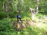
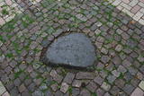
Stupeļu Hill is 3 km to the South of the Vecumnieki-Ilūkste road. There are no signs, so the castle hill might be difficult to find. The Great Stupeļu Rock, which is discussed further on in this guidebook, is also hard to find when there is vegetation. Stupeļu Hill is approximately 30 m high, and it was one of the highest castle hills in the historical district of Selonia. Archaeologists say that it was first abandoned at the beginning of our era and then populated again during the late Iron Age. It is interesting that iron was extracted and processed near the castle hill. Archaeologists believe that this is the site of one of the earliest “cities” in the region. To the West of the hill is the Great Stupeļu Rock, which is 6.7 m long, 5.6 m wide and up to 2.7 m high. Above ground, it is 35 m3 large, and it may have been a cult location. During archaeological digs in the late 1970s, antiquities from the 10th to the 13th century were found here. |
|
