
| No | Name | Description |
|---|---|---|
 |
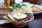
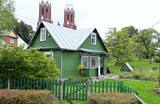
The saloon is on the corner of two historic roads – the Rīga-St Petersburg road and the Cēsis-Vecpiebalga-Madona road. It uses ingredients from local farms and vendors. Latvian cuisine: Grey peas with bacon, dumpling, beet or wild mushroom soup, bean salad, herring with boiled potatoes and cream, farmer’s ramekin, roast pork, potato pancakes, crepes, bread soup, strawberry dessert, homemade ice cream. |
|
 |
The family enterprise (formed in 2006) makes home-made ice-cream from fruit and berries. They make both classical – such as plombieres, cream, joghurt ice-creams and sorbets and nowadays cuisine’s „miracle”- sprat, blue cheese, horse-radish and potato ice-cream with tomato sauce. Till now 80 different ice-cream recipes have been tried. If you book a visit beforehand, you can have an excursion and learn everything about the process of making ice-cream from the chefs themselves. In the cafe it is possible to try different ice-cream dishes – each one with a different ice-cream sauce. The cafe also welcomes pets! Special foods: Horseradish ice cream with herring. |
|
 |
Das in 1671 gebaute Schloss wurde mehrmals umgebaut und die heutige Aussicht im Stil des Klassizismus hat das Schloss 1820 – 1923 erhalten. Der im 19. Jh angelegte Park mit einer Rotunde und einer Steinbrücke. Tematische Ausstellungen. |
|
 |
The Karaosta canal and its naval and submarine base date back to the tsarist era in advance of World War I. The former submarine base is now closed to visitors and is used for business purposes. The canal can be viewed from Pulvera Street and the restored Kalpaks bridge.
|
|
 |
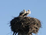
This is a large set of coastal meadows, ancient rivers and areas of reeds. It is found at a location where the Daugava River used to flow – between Vecmīlgrāvis and Vecāķi. There are inland dune meadows here, complete with the very rare silver grass. Vecdaugava is an important location for nesting birds and several uncommon plant species. On the southern end of the Vecdaugava peninsula, at a place called Skanstnieki, one can find remnants of medieval Swedish fortifications. The Vecdaugava Regional Research and Fishing Museum is here, as well.
|
|
 |
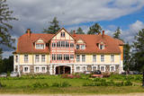
Находится ~ в 1 км на восток от центра Априки. Дворец господской усадьбы (стиль барокко) строился с 1742 по 1745 гг., а башня неоготического стиля как пристройка возводилась в конце XIX века. На фронтоне главного фасада дворца выполнен рельеф из песчаника с гербом родов баронов Остен – Сакенов и Корфов, который является самым роскошным элементом среди подобного рода имений Латвии. В здании сохранились и первоначальные элементы интерьера (осматриваются в сопровождении гида) – дверные створки, расписанная голландская печь, оконные дубовые ставни, коробки, чеканные металлические детали и паркет. В комплекс господской усадьбы входит дом управляющего, дом прислуги, хозяйственные постройки и парк. С 1920 года во дворце господской усадьбы действует школа и устроен музей края, который непременно следует посетить! Сейчас в музее выставлена коллекция этикеток производимого в Латвии хлеба. В 1901 году господскую усадьбу приобрел Карл Густав Маннергейм (1867 - 1951), который был президентом государства Финляндии и легендарным автором системы фортификации линий Маннергейма - Зимняя война (1939 - 1940). |
|
 |
We offer a private collection of ancient tools, household items and technologies which we began to assemble in 2002. Right now we have more than 5,000 objects of cultural and historical objects on display, as well as a lovely garden with countless compositions of colourful flowers, fountains, an Eastern meditation bridge, ponds, a pergola, leafy areas, etc. The garden covers more than 2 ha, and it is located 1 km from Lazdukalns. |
|
 |
The first Dnyestr-M radar station was opened here in 1969 to calculate the trajectories of ballistic missiles. The trajectories of satellites were also calculated here. The range of the radar station was 5,000 km. In 1972, construction began on a second, more modern radar, the Dnyepr-M. In 1977, it was ready for use, and the first radar was modernised at the same time. The two radars were located in buildings that were 250 m long and 17 m high. During a 24/hour period, they could identify the height, speed and flight trajectory of up to 750 space objects. In 1985, work began on a third, even more modern radar – the Daryal-YM. This was a radar that could “peek” across the horizon. The antenna building was 117 m high (19 stories), 80 m long and 80 m wide. It had a planned range of 6,000 km, but it was not completed. After the withdrawal of the Russian army in 1995, the building was blown up. That cost LVL 6,172,311 and used up 360 kg of explosives. The territory of the radar stations took up 1,072 hectares, with barracks, a hotel, 551 apartments, a medical facility, a water tower, a war hospital, a bomb shelter, etc. The aim of the facility was to monitor space above Western Europe and North America, as well as to “intercept” any ballistic missiles that were fired at the USSR. The territory is closed to visitors, but it is an important part of Latvia’s military heritage. The abandoned territory can be viewed from the outside. The nearby bus stop is called “Kombināts.” This was the only facility of its kind in the Baltic States. !!! Since March 2018 the Skrunda army base is closed for visitors. |
|
 |
Close to Otepää, in a very beautiful place, surrounded by woods and hills, Canterville loss is waiting for you. A great place to relax with your family. Large playground for children. The restaurant serves both romantic meals and lunch during workshops. |
|
 |
This lovely territory includes the hillocks of Embūte, which are in the ancient Embūte valley. The aim of establishing the park was to protect the landscape, biotopes and species of the region. An ecological tourism trail has been established in the valley, as has a forest trail through the nature park (accessibly only in the company of a guide). Visitors will learn about the hillocks and ravines left behind by the Ice Age. The ravines and the forests along their sides are protected biotopes. There are also important natural and cultural monuments, including the Embūte castle hill and the ruins of a baronial estate, castle and church. Other points of interest include the death place of the Courlandian warrior Indulis, the Joda dam, meadows, a viewing tower, etc. Three unmarked bicycle trails are in the area. |
|
 |
The “Pilsbergu krogs” guesthouse and café is 300 metres from the steep shores of Jūrkalne. It is in an historical building that has been restored. The Restaurant is open for the whole year. Foods from European cuisine as well as local dishes like local fish are served. Catering for tourist groups, banquet hall for up to 30 persons, restaurant hall for 25 persons and summer terrace for 30 persons. |
|
 |
Established in 1990, this museum features an orchard that was planed in 1935 and relates to the poetess Brone Buivydaite. |
|
 |
Vienu kilometru garā lokveida taka, kas ved pa lielāku nacionālā parka meža masīvu, uzskatāmi attēlo Žemaitijas augstienes un tuvākās apkārtnes reljefa veidošanās vēsturi. No takas augstākā punkta – Mikitai kalna, kas ir sens pagānu upurkalns, paveras (ainaviska stiga) tālākas apkārtnes skats. Kā takas interesantākie apskates objekti ir jāmin teikām apvītais akmens ar Velna pēdu un ar akmeņiem izliktas akas paliekas. |
|
 |
This territory protects a lime outcrop found on the shores of the lower reaches of the Zaņa River. There is a path for active hikers which begins at the Zaņa mill (1864, rebuilt 1890, shut down 1960). The path weaves its way along the steep shores of the little river, heading toward its mouth.
|
|
 |
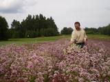
Saimniecībā tiek audzētas gaļas šķirnes (Suffolkas) aitas un piena šķirnes (Ostfrīzijas) aitas. Ganāpmulka aizsardzībai saimniecībā strādā ar sargsuņiem, Pireneju kalnu suņiem, kas ir pasaulē arī plaši pazīstama suņu šķirne mājlopu un mājputnu apsargāšanai no lielākiem un mazākiem plēsējiem. Saimnieki piedāvā iegādāties premium klases, saimniecībā audzētu, jēru gaļu un aitu piena produktus- Fetas tipa sieru, grilsieru, jogurtu bez piedevām un vairāku veidu saldējumus. |
|
|
| ||
 2 days
|
The Ķemeri National Park (est. 1997) covers wetlands, the shallow waters of the Bay of Rīga, overgrown seaside lakes, swamps, damp forests and wetland meadows. There are many important plants (including some 25% of those that are declared to be rare) and animals, including an area where the locations of nesting and migrating birds are protected. The park includes one of the largest swamps in Latvia – the Great Ķemeri Swamp. This is an important location for sulphurous waters and medicinal dunes, and back in history, that was the reason for the establishment of popular spas in Ķemeri. Visitors to the park are interested by educational nature trails, bike and hiking routes and bird watching towers. Route information from Latvijas Lauku forums |
|
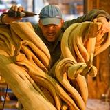 |
The master craftsman uses natural wood to produce furniture and interior design elements. He uses the tree from the tip to the root. Each artwork accents the form and texture of the wood, and the workshop offers an unusual look at wood and people. You can attend educational events and commission and purchase gifts and souvenirs. |
|
 |
The farm grows and collects more than 80 types of medicinal plants, including peppermint, marigold, chamomile, oregano, St John’s wort, wormwood, oats, creeping thyme, broadleaf plantain, field penny-cress, meadowsweet, etc. You can take a tour and learn all about medicinal plants and how they are used. During autumns, you can purchase medicinal teas. |
|
 |
Šis avots ir pazīstams kopš seniem laikiem. Kalpo kā laba dzeramā ūdens ņemšanas vieta. |
|


