
| No | Name | Description |
|---|---|---|
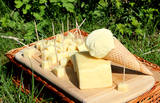 |
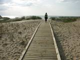
This summer terrace café is on the beach of the Preiļi park, and it offers 100% natural ice cream with berries, as well as fresh pancakes. The café is only open from Mother’s Day (May 8) until Father’s Day (September 11). Tourist groups are offered tours and tastings of cheese-based ice cream. |
|
 |
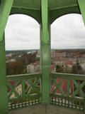
The museum is in Gunpowder Tower, which was an important component in the Medieval fortifications system of Rīga. The basic subject of the museum is Latvia’s military and political history, and exhibits are related to these subjects.
|
|
 |
This trail offers education about the forest for children of all ages, families with children, and friends of the environment. The trail is located in the Īle Parish of the Auce Administrative District, 2 km from the Pokaiņu forest. |
|
 |
The farmyard offers to see the domestic animals, birds and exotic maras as well as horse-back riding on a pony. You can get a consultation about gardening and breeding small animals. It is possible to buy quail eggs, smoked meats, chicken and birdlings. |
|
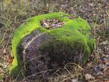 |
Zīleņu Sacrificial Boulder.You will find it on Zelenpole Golden hill beside the escarpment. The boulder
has an annular curvy. It was an ancient Latgalian cult place where people sacrificed to Gods, released themselves
from the bad things and took a positive energy.
|
|
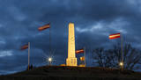 |
The monument is on a hillock along the lovely shores of Lake Alūksne and alongside Pleskavas Street (P 40). The monument was unveiled on June 20, 1923, by Latvian President Jānis Čakste and was designed by the sculptor Jūlijs Miesnieks. It features a shield with crossed words, and the text reads “For fallen soldiers from the 7th Sigulda regiment, 1919-1920), and on the other side there is a text “Better to take my head than our fatherland.” The monument was torn down during the Soviet occupation (1953) and restored in 2009. |
|
 |
The trail tells about the protected nature area which is found in Riga city and has been established to protect the seashore habitats (forests, meadows, reeds, dunes) and the birds, populating the daugavgrīva meadows. There is a bird watching tower with facilities for people with special needs.
|
|
 1 day
|
The Baltic Coastal Hiking Route leads around the Pakri Peninsula, from whose rocky shores you will discover the most beautiful coastal landscapes in northwest Estonia. It goes through the centre of Paldiski and, after having reached the fortress bastions of Peter I, it turns towards the Pakri Lighthouse going across the upper part of the impressive Pakri Cliffs. Further on up to Kersalu, there are both ups in the shape of rocks and downs where the Baltic Coastal Hiking Route meanders along a sandy and rocky seacoast and a beautiful pine forest. |
|
 |
From the tower of St Simon’s Lutheran Church, you can see the central part of Valmiera and the banks of the Gauja River. During clear weather, you can see Zilaiskalns Hill. The church contains some cultural and historical treasures, as well as one of Latvia’s most resonant pipe organs.
|
|
 |
The restaurant is alongside the Salacgrīva Tourism Information Centre, in an historical ice cellar for fish. The interior design is based on seamanship. Latvian cuisine: Cold beet soup, sea fish soup, fish and vegetable casserole, chocolate sausage, pancakes with strawberry jam, kvass. Special foods: Baked and grilled fish – perch, plaice, pike-perch. |
|
 8 days
|
The route brings you to Kaunas, multiple Lithuanian regional parks and allows to enjoy the landscapes of the river Nemunas. Kaunas is Lithuania’s second largest city. It is notable for its modernist architecture. The city is located at the confluence of the two largest Lithuanian rivers: Nemunas and Neris. Moving further from Lampėdžiai to Vilkija, the Forest Trail runs for two days along trails and small countryside gravel roads next to the right bank of the river Nemunas. This section is shaped by beautiful landscapes with views of the river, the waterfront meadows and small villages. Do not miss the ferry in Vilkija crossing over the river Nemunas, one of the few still in operation in the Baltic States. For the next two days from Vilkija, the Forest Trail runs through its most spectacular sections in the Dubysa Regional Park from Kirkšnovė to Šiluva with mounds on riverbanks and historical churches now and there. This regional park covers the impressive Dubysa river valley, which reaches a depth of 40 m and a width of up to 500 m. Be prepared for a rolling terrain. Next, the route will take you to the town of Šiluva – the Catholic pilgrimage site – and to the Kurtuvėnai Regional Park. It is among the most forested areas of Central Lithuania; thus, the regional park with its glaciated valleys is a wonderland of forests, waters and wetlands. The Forest Trail leads along small forest paths, tourist trails, beautiful tree alleys and wetlands. The walk ends in Šaukėnai village, from where the city of Šiauliai is easily reached. |
|
 2 days
|
This section of the Baltic Coastal Hiking Route is suitable to hardy hikers who like to travel across uninhabited places. In many places, reeds, floodplains with pastures and wetlands stretch across the Estonian seacoast, which is why the itinerary often leads you along forest and country roads. In the second half of summer you can pick the mushrooms and berries in the coastal forests. Pärnu is a popular resort city with many cafés, live music, SPAs, hotels and a beautiful Old Town. |
|
 |
Pajumäe is a small, nice organic farm located in the green Mulgimaa, and produces various dairy products. You will have the opportunity to look at all stages of milk production - from cows on the pastures to dairy processing. |
|
 |
Atrodas skaistā vietā – pašā Daugavas krastā. Ēdina, klāj galdus, piedāvā braucienus ar kuģīti pa Daugavu. |
|
 8 days
|
This tour has a very summery feel since it never wanders too far from the sea. Latvian sea resort Jurmala attracts with characteristic wooden cottages from the 19th century, Dzintari concert hall and a lively beach. Cape Kolka is located in Slitere National Park which also includes the traditional villages of the smallest ethnic group in the world, the Livs. Enjoy empty beaches and locally smoked fish. Ventspils is an immaculately maintained town with a medieval castle and well equipped beach. Pavilosta is Latvia's unofficial windsurfing capital, while Palanga in Lithuania has an excellent amber museum. Lithuania's pearl is the Curonian Spit and its lagoon which attracts with its vast sand dunes and Nida, a charming village with a Thomas Mann Museum. Back in Latvia, Liepaja is an exciting city with a historic quarter, beach, lively restaurants and clubs and a distinctive millitary heritage in the form of former naval forts and a military zone. Kuldiga is loved by artists due to its picturesque little cobbled streets with wooden houses and the Europe's widdest waterfall on the Venta river. |
|
 |
Baltijas valstīs lielākie brāļu kapi, kur izveidots (1974. - 1984. g.) piemiņas memoriāls (tēlniece P. Zaļkalne, arhitekti A. Zoldners, E. Salguss un dendrologs A. Lasis) 8 ha platībā. Šeit apglabāti ~ 23 000 cīņās par Kurzemes cietoksni jeb Kurzemes katlu (1945. g. pavasaris) kritušie Sarkanās armijas karavīri. Memoriāla centrā novietots12 m augsts Mātes - dzimtenes tēls, bet uz granīta plāksnēm iegravēti kritušo vārdi, starp kuriem ir atrodami arī daudzi mūsu zemes un kaimiņvalstu dēlu vārdi un uzvārdi. |
|
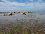 |
This is an important territory for the protection of reefs. It is opposite the Salacgrīva Administrative District and covers 3,577 hectares. The marine part of the “Rocky Shore of Vidzeme” nature reserve is a part of the territory.
|
|
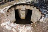 |
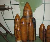
Today there’s a single-family farm and not much else, but at one time Olmaņi was the site of two important coastal batteries collectively known as “Krastnoflotskaya.” Until 1955, the one to the South of Olmaņi, there were four 152-mm Kane type cannons, which were manufactured during World War I and were widely used to protect the coastal territory of the Baltic Soviet republics of Latvia and Estonia during the rule of the Soviet regime. Small concentric ramparts of earth are all that’s left there today. After 1955, to the North of Olmaņi, another battery was installed with four MY-2 152-mm cannons. They had a range of 25 km. The battery remained in battle readiness until 1975, when it was turned into a reserve facility. It’s not easy to find, but it’s worth the search. The platforms for the cannons and the subterranean bunkers are still there. This was indeed one of the most impressive coastal batteries along the shores of the Baltic Sea.
|
|
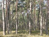 |
Ap 100 gadus veca priežu audze, ko iesēja pagājušā gadsimta sākumā. Sēklu materiāls bija nācis no kādas Vācijas (Darmštatē) sēklu tirdzniecības firmas. Mūsu klimatiskajos apstākļos priežu stumbri izauga līki un kroplīgi. Savdabīgā audze labi redzama no šosejas malas.
|
|
 |
In Estonian, Luitemaa means ‘the land of dunes’. It is the seashore territory of the Gulf of Pärnu, 13 km between Vöiste and Häädemeeste with shallow waters, vast coastal meadows, the highest dune range in Estonia and the Tolkuse Mire (Tolkuse raba). The Tolkuse mire trail (~2.2 km) and watching tower are available for dune and mire sightseeing tours. Situated in Luitemaa Nature Reserve. |
|


