
| No | Name | Description |
|---|---|---|
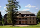 |
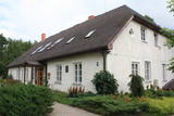
This estate is surrounded by an ancient and geometric landscape. During the latter half of the 19th century, it had a landscape style with various elements of geometry. The park covers 4.2 ha and has ancient linden, maple, elm, oak and other decorative bushes, with more than 20 types of plants that have turned into wood. |
|
 |
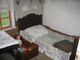
Port accommodation Kihnu delights guests with mostly local food - if something is needed on the island, Estonian products are preferred. Local foods are mostly prepared from fish and home-grown vegetables. |
|
 |
Kafejnīca "Kalnakrogs" atrodas Skrundas novada Rudbāržu pagastā pie Rīgas - Liepājas šosejas. Kafejnīcas ēdienkartē iekļauti latviskie ēdieni, iespējams pasūtīt banketu un izīrēt telpas semināriem. Piedāvā nakšņošanu. |
|
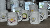 |
Since 2007, visitors have been able to tour a porcelain factory that offers an exhibition of porcelain products. You can buy souvenirs or commission special products. Children will love the porcelain painting studio that is in the mansion of the nearby Vecpiebalga Estate. |
|
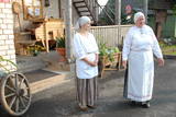 |
At this museum, you will learn all about the baking of bread from grain to loaf, and you can make your own loaves, too. You can taste bread and herbal teas. There are theatrical performances related to christenings, weddings, birthdays, etc. Local foods such as dumplings and soups made of dried mushrooms or lake fish are served. The museum sells freshly baked bread, as well as the work of local craftspeople. The hostess is a master baker and a member of the Chamber of Crafts. Latvian cuisine: Lake fish soup, cottage cheese dumplings and other traditional Lettigalian dishes. Special food: Soup of dried mushrooms. |
|
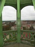 |
From the tower of St Simon’s Lutheran Church, you can see the central part of Valmiera and the banks of the Gauja River. During clear weather, you can see Zilaiskalns Hill. The church contains some cultural and historical treasures, as well as one of Latvia’s most resonant pipe organs.
|
|
 |
Pilsētas aizsargdambi upes labajā krastā (1830. - 1841., autors kara inženieris P. Meļņikovs) cēla ar mērķi aizsargāt pilsētu no applūšanas. Dambis stiepjas 5,6 km garumā. Pēc 1922. g. postošajiem plūdiem uzsākta aizsargdambja celtniecību arī Daugavas pretējā - kreisajā krastā. |
|
 |
All that remains today is the governor’s house in which the Latvian author Rūdolfs Blaumanis (1863-1908) lived from 1885 until 1887, and a stable built of fieldstones. The Central Daugava Forestry Centre of the Latvian State Forests company is located in the building. The stone gates of the
|
|
 |
Dabas taka atrodas Zaķumuižā un ved cauri vecajam muižas parkam, pa ceļam iespējams aplūkot simtgadīgus kokus, dažādus augus, kā arī dažādus kukaiņus, putnus. Taka ir veidota kā mācību taka un to veidojusi Zaķumuižas pamatskolas skolotāja. Taka ir 1,5 km gara. Tai ir vidējas grūtības pakāpe: takas reljefs ir samērā vienmērīgs, mērens, izņemot atsevišķus posmus (daži stāvumi un kritumi, dažviet nelīdzens reljefs), tāpēc īpaša fiziska sagatavotība pirms takas iziešanas nav nepieciešama. Vietās, kur reljefs ir stāvāks, izvietoti roku balsti, bet pāri muižas dīķu sistēmas ūdeņiem uzcelti divi tiltiņi.
|
|
 |
Saimniecībā, kura atrodas pašā Sēlijas novada centrā, aug un zied vairāk nekā 400 dažādu rožu šķirnes, kā arī siltumnīcās tiek audzēti dažādi dārzeņu un puķu stādi. Iegādei tiek piedāvāti dažādi viengadīgie augi, vairāki simti rožu stādi un ēdamaugu stādi siltumnīcai un dārzam. |
|
 |
Ap 9,5 km garais un līdz kilometru platais ezers atrodas subglaciālā – t.i. ledāja veidotā vagā, tādēļ tas ir ne tikai Lietuvas, bet arī otrs Baltijas dziļākais ezers (pēc dažādiem avotiem 60,5 m vai 62,5 m). Tauragna dienvidu krastā paceļas Taurapils pilskalns (Taurapilio piliakalnis). Saglabājušies nostāsti gan par pagānu priesteri, kas te dzīvojis, gan nogrimušu baznīcu, gan laikiem, kad pilskalnu no visām pusēm apņēmis ūdens. No pilskalna plakuma paveras visaptverošs skats uz Tauragnu. |
|
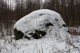 |
The historic stone, on which there is carved over 200 years old boundary-mark, sets the border between the Duchy of Courland and the Russian province. Nowadays, it sets the Babīte and Jelgava district boundary. The stone lies to the East of Kalnciems–Peat road (the south of the swamp Labais purvs) at the edge of a forest firebreak and it can be hard to find. To this end, the description of the road map may help: around 400 m south of the car parking lot at Lily Lake from Kalnciems-Peat road to the right (in the east) turns a forest road which leads down from hills Krāču kalni. It should be around 170 m to go until it abruptly turns to the right (to the southeast). Then you must go in this direction until after ~ 0.5 km to turn to the northeast where after further ~ 0.4 km of the current forest road intersection turn to the north. After ~ 0.4 km turn right (to the east) on a big firebreak, on the left (the north) side of which behind the drainage ditch during the non-leaf period there can be seen a rounded stone. Due to the poor condition of roads, the stone can be reached only on foot. |
|
 |
The main building of the museum features an early 19th C. threshing barn with a dirt floor, the living quarters were added in the late 19th C. The museum also exhibits a smoke sauna, summer kitchen, granary, cellar, coach house and a dining house (formerly a cattle shed). All buildings have a display of tools and everyday commodities, traditional farm food can be booked in advance and handicraft workshops are available. |
|
 |
Eine der größten befestigten Siedlungen im Bezirk Harju, befindert sich auf einer Erhebung des natürlichen Kliffs Nordestlands. |
|
 |
Piedāvā ļoti gardus Lietuviešu tradicionālos ēdienus. Var pieņemt līdz 300 personām. Ir āra terase un dzīvā mūzika. Pieņem bankas kartes, pieejama autostāvvieta. |
|
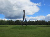 |
Not far from the Rīga ring road on the Right Bank of the Daugava is a monument designed by the sculptor Ģirts Burvis in 1994, which is dedicated to the Livs of the Daugava region and their Mārtiņsala leader, Ako, who led a battle against the Holy Crusades in 2016. Around the monument is a large area for leisure and perambulations. This is one of the loveliest locations in the lower reaches of the river. A bit further along are information stands about the history of the banks of the river before the construction of the Rīga hydroelectric power plant. |
|
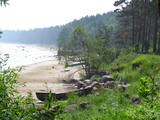 |
There are both sandy beaches with a good infrastructure and a rock beach in Roja. The rocky beach leads to a huge rock that is 2 m high and 12.5 m in diameter. The coastline is lovely with its scattered stones and its unhurried rhythm of time. At the place where the Silupīte River flows into the sea there are remnants of ancient wooden boats and iron nails. In 1939, Roja became the starting point for a closed zone, because the Soviet army and navy were sited there until 1993. The dunes at Krasta Street feature Soviet heritage, including a large cement wall from which border guards used to monitor the sea and catch those who violated the border. Behind the dunes was a base for border guards with everything they needed. Roja housed a Border Guard post and an air defence radio locator. (Source: Roja TIC) |
|
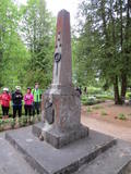 |
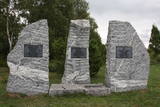
The monument is in the Bērtuļi cemetery and has a brass plaque that reads “With deep thanks to fallen heroes of the Latvian people. The 10th Rūjiena Vanagi district.” On the other side of the monument, the words “God, Fatherland, Nation” are engraved. The monument was restored in 1989. |
|
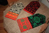 |
The basic exhibition at the museum, “Traditions Related to the Sewing and Wearing of Bārta Folk Costumes From the 19th to the 21st Century”, features folk costumes for unmarried and married women, as well as for men, emphasising the diversity of elements therein. Visitors can help to embroider or weave blouses. The Bārta Ethnographic Ensemble offers two educational programmes – “The Bārta Folk Costume” and “Singing Women From Bārta”. |
|
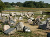 |
The craftsman produces gravestones, commemorative plaques and stone sculptures on the basis of orders from clients. He is prepared to tell you about a stonemason’s work and demonstrate his skills. |
|


