
| No | Name | Description |
|---|---|---|
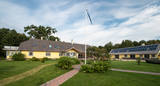 |
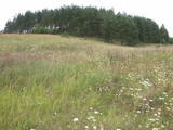
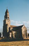
Nurka Farm is located in Luitemaa Nature Protection Area in Pärnu County. The farm complex that is over 100 years old has been renovated into a contemporary holiday farm with all modern conveniences. |
|
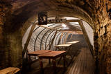 |
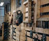
The most fascinating part of the Park is its underground museum. Guided underground tours take visitors to where miners used to work and rest and stored their explosives, and include a real train ride and learning about various pieces of equipment and technology. A delicious miner’s lunch can be booked in advance and enjoyed in a genuine miners´ underground canteen. |
|
 |
Informatīvi bagāta un interesanta dabas izziņas taka, kas ved pa Gaujas tuvumā esošajiem krasta biotopiem – boreāliem mežiem, nogāžu mežiem, gar vecupi, jauktiem lapu koku un platlapju mežiem, kā arī parkveida ozolu pļavām. Ziemeļgaujas aizsargājamo ainavu apvidū esošie meži ir vieni no sugām daudzveidīgākajiem Latvijā. Taka ir marķēta, izveidotas skatu platformas, izvietoti informatīvie stendi. Kopējais takas garums: 2,2 km |
|
 |
This guest house is in an old baronial estate on the banks of the Neris River. You will love the landscape, the opportunity to swim in the Neris River, or ride a bike. The owners are architects who teach classes about ethnic architecture. |
|
 |
This partly forested hillock stands 40 metres above the surrounding area and offers impressive views. The fact that this was once a castle hill is attested by the presence of a moat and remnants of defensive fortifications. It is thought that Lettigalian tribes settled here in the 10th century AD. You can climb the hillock to take a look at the surrounding landscapes. |
|
 |
Торговый канал, протяженностью неполных 3 км, в советское время являлся закрытой зоной со статусом режима приграничного района. Лиепайский порт был известен еще в XIV столетии. В конце XVII века здесь выкопали канал, который соединил море с Лиепайским озером - теперешний Торговый канал. Заканчивается он Зимним портом и двумя молами, из которых Южный мол служит излюбленным местом для прогулок и рыбалки. В южной части Торгового канала тянется Променад, на котором установлены Янтарные часы. |
|
 |
The first Dnyestr-M radar station was opened here in 1969 to calculate the trajectories of ballistic missiles. The trajectories of satellites were also calculated here. The range of the radar station was 5,000 km. In 1972, construction began on a second, more modern radar, the Dnyepr-M. In 1977, it was ready for use, and the first radar was modernised at the same time. The two radars were located in buildings that were 250 m long and 17 m high. During a 24/hour period, they could identify the height, speed and flight trajectory of up to 750 space objects. In 1985, work began on a third, even more modern radar – the Daryal-YM. This was a radar that could “peek” across the horizon. The antenna building was 117 m high (19 stories), 80 m long and 80 m wide. It had a planned range of 6,000 km, but it was not completed. After the withdrawal of the Russian army in 1995, the building was blown up. That cost LVL 6,172,311 and used up 360 kg of explosives. The territory of the radar stations took up 1,072 hectares, with barracks, a hotel, 551 apartments, a medical facility, a water tower, a war hospital, a bomb shelter, etc. The aim of the facility was to monitor space above Western Europe and North America, as well as to “intercept” any ballistic missiles that were fired at the USSR. The territory is closed to visitors, but it is an important part of Latvia’s military heritage. The abandoned territory can be viewed from the outside. The nearby bus stop is called “Kombināts.” This was the only facility of its kind in the Baltic States. !!! Since March 2018 the Skrunda army base is closed for visitors. |
|
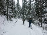 |
The nature park near the town of Ogre is a popular place for leisure, hiking and, in the winter, cross-country skiing. Most of the park is covered with coniferous trees that are on a long and comparatively narrow line of hillocks with steep sides – another element of nature left behind in Latvia by the Ice Age. Many different plants can be found here. The Jaunogres castle hill is one of the most distinct hillocks in the area. |
|
 |
This is Latvia’s largest lake island and is found in the middle of Lake Usma. The island is restricted to protect old stands of pine, as well as various plants and birds. |
|
 |
The restaurant is in the centre of Jelgava among residential buildings. It is known for its interesting interior and for the musical and other events that it organises. Latvian cuisine: Farmer’s omelette, roast pork with chanterelles and wild mushrooms, grit risotto, strawberry soup with ice cream, crepes. Special foods: “Kiss from Šarlote” – layered egg-cottage cheese crème and jellied juices. |
|
 |
Zilais (Blue) Hill is the highest point in the Idumeja highlands – it is a very distinct hillock covered by forest, and from it there is a “narrow” landscape featuring the northern part of the highlands, as well as the Burtnieks flatlands. The restricted area is there to protect habitats such as gullies, hillsides and the boreal (northern) forest of the area. Zilais Hill is a popular tourist destination.
|
|
 |
The church was built of fieldstones between 1908 and 1925 in the Tudor Neo-Gothic style (designed by the Liepāja-based architect Stadmann). It replaced a wooden church that dated back to 1621, and its steeple offers a lovely view of lakes that surround the village of Višķi. |
|
 |
Vidzemē, Valmiermuižā, 19.gs. celtā ēku kompleksā, ko iekļauj mūra žogs, atrodas Valmiermuižas stallis un Valmiermuižas jātnieku skola. Tajā saimnieko Jurašu ģimene - zirgkopju, zirgu selekcionāru un vetārstu ģimene daudzās paaudzēs. Ir iespēja doties izjādēs, ekskursijās, kā arī tiek rīkotas radošās nometnes bērniem. |
|
 11 days
|
The tour begins in Riga with its Art Nouveau district and Old Town. Make your way to Sigulda by train. A hilly road passes Gutmana Cave, Turaida Castle and Krimulda Castle which stand on the hillsides of the Gauja river valley. The road continues to Limbaži, which is a typical Latvian provincial town. Further on you reach the Baltic Sea coast and Salacgriva, which is famous for its fishing traditions and lamprey. Outside Salacgrīva town there are rare coastal meadows and lagoons. After crossing the Latvian-Estonian border point, the road winds through old coastal villages - Ikla, Treimani, Kabli and Häädemeeste before rejoining the Via Baltica. At Pärnu explore Ruutli pedestrian street and the old fortifications. It is time to cross to the islands - the route passes through the small island of Muhu. Visit the local fish cafe at Livi and ethnographic fishermens’ village of Koguva. Then the route leads to Saaremaa island over a causeway. The main sites on the route are 'Valjala maalinn' – one of the most attractive hill forts in Estonia, the Valjala church, and meteorite craters of Kaali. By bus you head to the Estonian capital, Tallinn, charming with its medieval Old Town. From there take a tour of a former Soviet submarine base at Paldiski, a memorable reminder of recent history. |
|
 |
Pļaviņās, pie Daugavas ielas, Daugavas krastā uz laukakmeņiem novietots plosta modelis ar stendu (2011. gads, biedrība „Kopsolis”), kur izlasāms stāsts ar plostnieka atmiņām un aplūkojamas vēsturiskās plostnieku fotogrāfijas. Daugavas posms starp Pļaviņām un Koknesi bija visgrūtāk pārvaramais plostnieku šķērslis ar krācēm un līdz 20 m augstiem, klinšainiem upes krastiem. |
|
 |
Kassinurme hills were formed during the last Ice Age, and an ancient stronghold and a sacred grove can be found in the hills. At the foot of the stronghold a stage has been built; a swing, tepees, a campfire place and a model of the stronghold are located in the forecourt. Nature, health and antiquities trails are located nearby. |
|
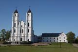 |
This is the centre for Catholicism in Latvia and a destination for pilgrims from all around the world. Its origins date back to 1699, when the Dominican Order established a cloister. One year later, it built the first wooden church. The brick Church of St Dominic and the buildings of the cloister were erected between 1768 and 1800. The Baroque church is distinguished by two towers that are 60 metres high. The pulpit, organ prospectus, organ, prayer bench and pews come from the 18th century, while the side altars date back to the early 19th century. The central altar includes the painting “The Miraculous Mother of God of Aglona,” which is thought to have healing properties. For that reason, it is unveiled only during important events. In advance of a visit to Latvia by Pope John Paul II in 1993, the complex underwent major rebuilding and restoration. On August 15 each year, hundreds and thousands of pilgrims arrive in Aglona to celebrate the assumption of the Virgin Mary. The holy stream of Aglona is 100 metres to the East of the basilica. |
|
 |
Kloostrimetsa is a cider brand with centuries-old traditions. They specialize in crafting high-quality cider using traditional methods, where the cider is made from their own carefully grown apples, allowing the juice to naturally ferment to preserve its authentic flavor. In addition to cider, they also produce jams, juices, and syrups in their home kitchen. Their gardens and fields are home to various fruits and berries, including chokeberries, sea buckthorn, and blackcurrants. In spring, birch and maple sap is harvested for seasonal products. The farm practices sustainable methods, utilizing solar energy and gentle land management. |
|
 |
One of the highest dunes in Latvia, located between Bernāti and Jūrmalciems villages. It is 37m high and offers a magnificent view of the sea and natural pine forests. The highest dunes in Latvia stand to the South of Jūrmalciems village: the Pūsēnu hill, the Ķupu hill, the Mietragkalns or Tiesas hill, the Pāļu hill, the Garais hill, the Ātrais hill, the Lāvas hill. The Pūsēnu dune is the highest of these dunes which are all called hills by the local people. The Pūsēnu hill developed between 1785 to 1835 when shifting sand became extremely dangerous. Several homesteads were buried in sand, among them „Pūsēni”, where a forester’s family lived. The family is said to have moved to Bārta. The dune was named after the buried homestead. Jēkabs Janševskis, a Latvian writer, wrote in his book „Nīca”: “In olden times, large pine trees were growing in the dunes on the coast of Nīca and they stood steady and firm. But i Swedish times (around 1650), the Swedes built a large kiln for charcoal and tar. Pine wood and stumps provided an excellent material for this. Once a big fire rose, and the charcoal kiln burned down as well as the whole pine forest. The remaining stumps and bare trunks in the vast burnout could not hold the storm-driven sand; it flew further and further burying not only the burned-out forest, but also the nearest fields. In wintertime, when the vast, low marshy grasslands were covered with ice, jets of sand drifted further over its surface, and soon most of the grasslands and large meadows turned into sandy heath-land and dunes.” To reconstruct Liepāja, severely damaged during WWII, a silicate brick factory was built in the town. The main raw material was white sand and it was taken from the Bernātu forest. In the 1960-ies they started to dig off the Green Dune and the White Dune, later also the Pūsēnu hill. The excavators used to work day and night, in three shifts. The work stopped at around 1980, as there was no more sand suitable for production of brick. A trail is set up to facilitate walking in the Pūsēnu Dune in the Bernātu Nature Park. |
|
 |
Mājas restorāns mājīgā, autentiskā lauku vidē, kur tiek pasniegti lauku ēdieni, uz galda celtas svaigas jūras veltes, kuras atceļojušas no Francijas, Spānijas vai Norvēģijas, kā arī vietējās, pašu saimnieku kūpinātas zivis. Ēdienkarte tiek radīta katru dienu no jauna, kas ikdienā ļauj piedāvāt svaigus produktus.
|
|


