
| No | Name | Description |
|---|---|---|
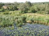 |
This is a territory which regularly floods when the Lielupe River crosses its banks. These are flood-land meadows of importance to birds. The area can be surveyed from the Rīga-Liepāja highway and the Kalnciems road which runs along it. |
|
 |
This former training route runs through the shoreline forests from the northern part of Ventspils (there was once a tank division in Ziemeļu Street there) all the way to Ovīši. Today it is a wide, sandy and overgrown track.
|
|
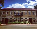 |
Small style hotel (6 rooms) - a cafe located in the historical center of Aluksne, 10 minutes walk from the Livonian castle ruins. Many of the hotel’s rooms have wonderful views, including to Alūksne Evangelical Lutheran Church, Cultural Center, art school, lake. Alūksne Castle Island or Marija Island is nearby; from there you can get to Tempļakalns park via a pedestrian bridge. Prepare your own fresh (frozen) berry ice cream, cakes and custom dishes. Seasonally offers different varieties of fruits and berries: strawberries, apples, pears. Orchard 3 km from the town with 1000 fruit trees. |
|
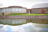 |
This is a modern and contemporary centre, including an old and restored granary. It offers an exhibition hall, an historical exhibition, a shop where you can purchase crafts, and a conference hall. Craftspeople from the region work here, and you watch them at work or try your own hand at what they are doing. |
|
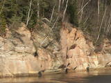 |
Boaters along the Gauja will see the Velnala cliffs, which are the last mighty wall along the banks of the Gauja River valley – approximately 15 m high. From the opposite shore of the river, where there are leisure facilities, once can spot the Krimulda Devil’s cave, which is in the centre of the cliff, is some 19 m deep, and is 4.7 m high. There were once wooden structures which allowed people to visit the cave, but that stopped in 1980 for safety reasons. If you head toward Turaida along the lower part of the basic Gauja River shoreline from the Velnala cliffs, then, particularly when the trees are bare, you will see the mighty sandstone Piķene cliff. At its foot is the Piķene beaver trail, which is approximately 1 km long. On quiet evenings, you may well spot a beaver at work. Along the path you will see the Small Devil’s cave (5 m deep) with the Wisdom Stream that flows out of it. The Aunapiere cave is almost as deep. Between the cliff and the Gauja are several small rivulets which are of enormous importance in preserving the diversity of the surrounding environment. |
|
|
|
This is a small river in a very deep and broad valley that is crossed by the Vecumnieki-Ilūkste road. Vilkupe was named in relation to the ambitious plan of Duke Jacob of Courland to link the river basins of the Daugava and the Lielupe rivers. Vilkupe was meant to be one of the components in this canal. This is a good place to think about the scope and innovation of Medieval people and their ideas. A fragment of the canal is marked and can be seen a bit less than 4 km from the populated location that is also called Vilkupe.
|
|
 1 day
|
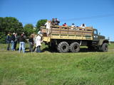
Dodieties ekskursijā, lai gūtu ieskatu lauku profesijā un dzīvesveidā, kā arī iegūtu jaunus iespaidus un labu atpūtu visai klasei. Ekskursijas laikā apmeklējiet maizes ceptuvi, kurā pielieto no seniem laikiem izkoptās meistaru zināšanas un prasmes. Te var doties ekskursijā, veidot un cept maizes kukulīti. Pēc tam apmeklējiet atpūtas kompleksu, kur iespējams gan ieturēt maltīti, gan izstaigāt baskāju taku. Ekskursijas noslēgumā dodieties uz kazu saimniecību, lai noklausītos saimnieka atraktīvo stāstījumu par kazu audzēšanu un piena produktu (piens, siers, kefīrs) ražošanu. |
|
 |
At the estuary of the Inčupe River, there is the White Dune, which is around 18 metres high and is the most lovely element of the Vidzeme shoreline among those that have been created by the wind, sand and sea. There is a wooden footpath (the Saulriets trail) which is meant to view, but also protect the dune. It has a viewing area, too. The territory to the south of the river is in the Piejūra Nature Park.
|
|
 |
The History Museum of Malta. Exposition „History of Malta parish: from
Rozentova and Borovaja to Malta”. We offer household items, tools of trade,
works of art, collection of paper money and coins. Excursion outside the museum
„At the cross-roads of Malta”.
Working hours: Mon– Fri : 9.00 – 17.00, Sat., Sunday : closed |
|
|
|
Māras birzs atrodas apmēram 4 km no Īles, Zebrenes virzienā. 2012.gada pavasarī iestādītā piemiņas birzs ir biedrības „Zebrus draugi” veltījums šīs apkaimes ļaudīm un viņu dzimtajām mājām, kas pēdējā gadsimtā ir zudušas no Latvijas kartes. Valsts meža izcirtumā iestādīto jauno kļavu, liepu un ozolu birzs centrā izveidots Māras altāris – simbolisks akmeņu krāvums, kurā katrs, kas jūt piederību šim apvidum, var pievienot savu akmeni. Birzs projekta un altāra autors - V.Lukjanovs. |
|
 10 days
|
From Riga the tour goes to Sigulda where you can see the Olympic Bobsled truck, visit Sigulda medieval castle and take a cable car across to Turaida medieval Castle with beautiful views across the Gaujas Valley. Kids would love activities at the adventure centre Tarzans. At Ligatne walk Nature trails to see the local wild animals at their enclosed territories and wonder around the historic village originally formed around the Paper Mill. Further on visit impressive medieval castle ruins at Cesis town and the picturesque Devonian Zvarte outcrop at Karli. Then the route goes along the coast with sandy beaches great for walking, playing and swimming. There visit museum of the biggest liar in the world - Munhauzen and listen to his fantastic adventure stories. Then the route goes to the Western part of Latvia and focuses on the sea and coastal life. From Riga visit the sea resort Jurmala, stop at Pure Chocolate Museum and then continues to Cape Kolka where open sea meets Riga Bay. There explore trails at Sliteres National Park, visit villages of Livs which is one of the smallest ethnic nations in the world, enjoy freshly smoked fish. At Ventspils enjoy endless facilities for children - kids town, narrow gauge train, aqua parks, well equipped beach and adventure park. On the way to Riga visit charming Kuldiga with well preserved wooden architecture and stop at the farm where kids could enjoy different farm animals |
|
 |
Atrodas Rucavas – Bārtas ceļa malā (pagrieziens uz Bārtas Romas katoļu baznīcu). Veltīts melioratoram Arvīdam Manfeldam – bijušā Liepājas rajona meliorācijas uzņēmuma priekšniekam kā pateicība no vietējiem iedzīvotājiem par ceļiem un tiltiem. |
|
 |
4 km garā un marķētā taka iepazīstina ar dziļo Imulas ieleju – Abavas kreisā krasta pieteku. Īpaši iespaidīga ieleja izskatās bezlapu periodā, kad ir apjaušami tās izmēri un formas. Vēstures cienītāji var upes gultnē uzmeklēt Langsēdes Velna pēdas akmeni. Atrodas dabas parkā „Abavas senleja”. |
|
 |
The tree farm focuses on decorative plants, including summer and perennial flowers, fern and collections of peonies. Flower containers and pyramids are made on order. The farm delivers and installs vertical “green walls”. The farm also offers Christmas products and materials for floral design. |
|
 |
Ap 6 km garā pussala ir vieta, kur jānokļūst tiem, kas grasās doties vienā no neparastākajiem pārgājieniem pāri jūras šaurumam. Cauri Kūsnemmes pussalai līdz tās ziemeļu daļai iet šaurs un ļoti līkumains grants ceļš (ar garāku tūristu autobusu jābrauc lēni un uzmanīgi), kura galā izveidots autostāvlaukums, neliels namiņš, kur patverties lietus un vēja laikā, kā arī informācijas stends. Turpat redzamas divas Padomju armijas „KRAZ” tipa automašīnas. Lai sasniegtu robežkontroles posteni, Padomju robežsargi brauca pa jūru un mazajām saliņām, kas kā pērļu virtene savieno Kūsnemmes pussalas galu ar Vilsandi salas dienviddaļu. Turpat divas desmitgades pēc Igaunijas neatkarības atjaunošanas „KRAZ” automašīnu kravas kastēs vasaras laikā uz Vilsandi vizināja tūristus, taču spēkrati savu mūžu ir nokalpojuši un unikālais piedāvājums vairs nav spēkā! Ko darīt? Pa mazajām saliņām uz Vilsandi var doties ar kājām. To var īstenot tikai siltā laikā, kad nav gaidāms stiprs vējš un ir zināma laika prognoze vismaz divām tuvākajām dienām. Kā sava veida orientieris var kalpot augstsprieguma elektrolīnija. Kopumā ir jārēķinās arī ar 1 h 40 – 2 h ilgu un ~ 4 km garu gājienu. Dziļākā vieta (ja ietur pareizo „kursu”) atrodas pārgājiena sākumdaļā, kur starp saliņām izveidots laivu ceļš - ~ 1 m dziļa vieta atkarībā no vēja virziena un ūdens līmeņa. Zināmu priekšstatu par maršrutu sniegs redzamā ainava, kas paveras no skatu torņa. Kaut arī šis maršruts tiek reklamēts dažādos informatīvajos materiālos, atbildību par tā veikšanu uzņemas katrs pats! |
|
 |
The hatchery of decorative saplings and their sale (thujas, junipers, meadowsweets, weigelas, barberries, roses, etc.); creating and nurturing a commercial black currant garden, consultations. |
|
 |
Possibly the highest bee apiary in the Baltics, about 300 m above sea level. Organic beekeeping products are harvested in Gaiziņkalns and its surrounding area. We offer excursions in the farm, bee apiary workshops, tasting of beekeeping products. |
|
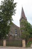 |
Atrodas Raiņa ielā 18. Baznīca celta 1911. - 1912. g. pēc Stukmaņu muižas nomnieka barona R. Noldes iniciatīvas. 1. pasaules karā cietušo baznīcu atjaunoja un no jauna iesvētīja 1921. g. Baznīcā apskatāma altārglezna “Kristus augšāmcelšanās”. Dievnams tāpat kā daudzas citas pilsētas ēkas ir būvētas no apkaimē sastopamā izejmateriāla – dolomīta. Interesanti, ka tornis būvēts ēkas vienā malā – asimetriski. |
|
 |
Atrodas Amatas ielejas augstajā krastā, autoceļa (A 2) Rīga – Veclaicene malā. Plašs ēdienu klāsts, lielas porcijas, iecienīta tālbraucēju šoferu maltītes ieturēšanas vieta. |
|
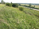 |
This territory protects the shore of the onetime Baltic lake of ice, which most significant part stretches for 10 kilometres on the eastern side of the Grobiņa-Ventspils highway from Kapsēde till Vērgale bus stop. From the top of this ancient shoreline there is a lovely view of the Piejūra lowlands, but no specific viewing areas or information stands have been installed. There are protected species and habitats in the territory. |
|


