
| No | Name | Description |
|---|---|---|
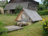 |
Information about this stream dates back to the mid-18th century, but people used it much earlier than that. People donated money to the stream after washing or drinking the water. During the first half of the 19th century, the baron of Tirza and the local church waged a battle against pagan traditions, though not very successfully. There is now a canopy over the stream, and people still drink its water. |
|
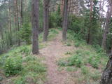 |
This is another so-called hill left behind by the Ice Age – five kilometres long with a height of between 15 and 30 metres and with high hillocks and steep hillsides. Te most distinct part of the hill can be found between Lake Pinti and Lake Šeški. The pine forests on the hillocks are a habitat with many rare and protected species. A trail has been established to tour Grebļa Hill, as well as Āža Hill and Kausu Hill, but it is recommended that visitors travel the trail in the company of a guide. The biological diversity of the area is made clear if one knows, for instance, that more than 500 kinds of butterflies have been found in the restricted territory.
|
|
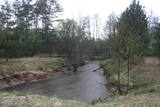 |
Nature restricted area is located to the South from former railroad Ventspils-Liepaja and includes approximately 6 km of Uzava River (and the old drainage system). The territory was used for agriculture during Soviet time, now it starts overgrow by scrubs. The protected nature values – rare bird species, including corncrakes, variety of grassland habitats and plant species. Territory is not useable for tourism activities. There is a possibility to get good insight into the North part of restricted area from the road Alsunga – Berzkalns where information stand is located.
|
|
 |
In the Alatskivi historical ice cellar wine, herbal teas, various snacks, spicy vinegars and jams are made from fruits of local meadows and forests. In the cosy boutique you can taste and buy wines, teas and other local food souvenirs. If the group is bigger or you want to visit us outside of working hours, it is desirable to notify us about your arrival in advance. |
|
 4 days
|
This route passes along one of the most diverse and beautiful parts of the coastline of the Bay of Rīga. You will see the Randu meadows, which are known as Latvia’s open-air “herbarium” because of the diversity of plants that can be found there. The coast features various sizes of rocks and stones, as well as no shortage of lovely and sandy beaches. This is the only place in Latvia where Devonian sandstone cliffs can be seen. Past each horn there is a different landscape, and the last 20 kilometres of the route are paradise for bird watchers during migration season. The route is in the Northern Vidzeme Biosphere Reserve. Route information from Latvijas Lauku forums |
|
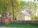 |
St. Michael the Archangel Parish Church of Zosna. The church
was built in 1800 by the donations of local people; it is devoted to Saint Michael. The church is built on the
stone foundation and panelled with boards. It has a small square tower that was restored in 1994.
|
|
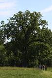 |
The tree is on the side of a hillock, and its visible roots are unusually huge.
|
|
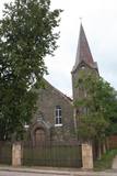 |
Atrodas Raiņa ielā 18. Baznīca celta 1911. - 1912. g. pēc Stukmaņu muižas nomnieka barona R. Noldes iniciatīvas. 1. pasaules karā cietušo baznīcu atjaunoja un no jauna iesvētīja 1921. g. Baznīcā apskatāma altārglezna “Kristus augšāmcelšanās”. Dievnams tāpat kā daudzas citas pilsētas ēkas ir būvētas no apkaimē sastopamā izejmateriāla – dolomīta. Interesanti, ka tornis būvēts ēkas vienā malā – asimetriski. |
|
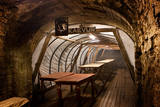 |
The most fascinating part of the Park is its underground museum. Guided underground tours take visitors to where miners used to work and rest and stored their explosives, and include a real train ride and learning about various pieces of equipment and technology. A delicious miner’s lunch can be booked in advance and enjoyed in a genuine miners´ underground canteen. |
|
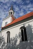 |
Atrodas Iecavas upes ielokā starp Rīgas un Sporta ielu. Baznīcas celtniecību uzsāka 1641. g. un pabeidza ap 1657. g. Ēka ievērojami cieta 2. Pasaules kara laikā. Pie baznīcas atrodas kapi, kuros apglabāti grāfu Pālenu dzimtas pārstāvji. To ziemeļaustrumu stūrī redzama Pālenu dzimtas kapliča. Baznīca ir it kā „sadalīta” divās daļās – vienā daļā notiek restaurācijas darbi, otrā izvietota bibliotēka. To ir vērts redzēt arī no iekšpuses. |
|
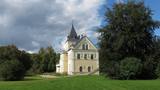 |
The museum is in the mansion of the Dole Estate, which was built in 1898 for the Loeuwis von Menar dynasty. The collection presents Daugava as an important water route, with the apparel of Baltic and Liv tribes, everyday objects, etc. Outside the movement is equipment to catch lampreys and a reconstructed weir to catch salmon. Alongside is a 17th century cannon from the Duchy of Courland that was found in the Misa River and was cast in Baldone. Nearby are four cannons from the Russian tsar’s army. Those were found on a building lot in Salaspils in 2007. |
|
 |
Teirumnīku purvs ir latvijas lielākā iekšzemes mitrāja - dabas lieguma "Lubāna mitrājs" sastāvdaļa, kas meklējams dienvidaustrumos no Lubāna ezera. |
|
 19 days
|
The tour starts at former Hanseatic port town Gdansk with its pretty Old Town, then continues to Malbork, an impressive fortified medieval castle and on to laid-back Formbrok with a magnificient Gothic cathederal. The route crosses the Mazurianlake district where hundreds of lakes are connected to rivers and canals, best expereinced from the deck of a boat. Continue to Wigry National Park with walking trails and interesting archaeological and cultural remains. Further into Lithuania, Dzukija National Park has several well preserved traditional farmsteads and villages which are well worth a visit. It's a good place to experience Lithuanian crafts and traditions, for instance bee keeping. Then the route goes via Kaunas to the Curonian Spit formed by shifting sand dunes between its lagoon and the sea. Pretty little villages are located along its length. Next the route goes to the sea resort Palanga with a great Amber Museum and on to Latvia. Stop at Pape Nature Park, a diverse mosaic of nature’s ecosystems, where wild horses and oxen breed. Slītere National Park shows the historical development of the Baltic Sea. Cape Kolka is a prime spot for bird migrations, Slītere lighthouse provides a great view of the surrounding forests and traditonal Liv villages, one of the smallest ethnic groups in the world. The Ķemeri National Park includes different types of wetlands and vast bogs. It is famous for its sulphur springs. Walk a Great Heath trail there and try the curative spring water. Further on Gauja National Park is formed around the ancient valley of the Gauja river with picturesque sandstone cliffs from the Devonian period. Here are many historic monuments – medieval castles, churches and ancient settlements which you can see crossing the valley on a cable car. Ligatne Nature trails offer a chance to observe local wild animals. Saaremaa's landscape is characterised by large juniper growths, dolomite cliffs, windmills, medieval churches and the famous Kaali meteorite lake. It also retains a very Estonian soul. Sooma National Park has contrasting swamps. Walk a beaver trail there and try 'bog-shoeing'. Lahemaa National Park has a rugged coastal andscape with big boulders, traditional fishing villages, forest trails and romantic manor houses. From Tallin take a ferry to Helsinki, from where it is an easy trip to Nuuksio National Park, home to an endangered flying squirrel. The landscape here is dominated by valleys and gorges, rocky hills covered by lichen and sparse pine forest that is very different to the previous parks. Well-equipped walking trails have several scenic views. |
|
 |
Viens no jaunākajiem Latvijā celtajiem mūra tiltiem. Tā akmens margas ir barona Karla fon Manteifeļa dāvinājums (celts 1907. gadā) Aizputei. Tilta ziemeļu puses margās ir iemūrēta granīta plāksne ar Manteifeļu dzimtas ģerboni, kas ir vāji izšķirams. |
|
 |
"Dobele Agra S.I.A." ir moderns, nākotnes perspektīvā domājošs lauksaimniecības uzņēmums Latvijā. "Dobele Agra S.I.A.", kas atrodas netālu no Dobeles - Krimūnās, kā viens no lielākajiem aramzemes apstrādātājiem Latvijā pašlaik apstrādā apmēram 5 800 ha lauksaimniecības zemes Dobeles un Jelgavas rajonos. Uzņēmums specializējas graudaugu audzēšanā pārdošanai vietējos un starptautiskajos tirgos, tādējādi gadā tiek saražotas apmēram 20 00 - 25 000 tonnas graudaugu, no kuriem lielākā daļa ir kvieši mieži, rapsis un pākšaugi. Pārsvarā tiek audzētas ziemas šķirnes. |
|
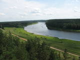 |
This nature park is one of the richest and most unusual nature parks in Latvia in terms of its natural resources, the surrounding environment, the landscapes, the biological diversity of the area, and the cultural monuments which are found there. The main treasure there is the little-changed Daugava River valley, where there are eight major curves in the river at a length of four to eight kilometres. There are also the gullies of river tributaries. Outstanding views can be found on the steep shores of the Daugava River valley, particularly the Slutiški and Ververi cliffs and the Elerne gravel hill. There are some 20 archaeological monuments on the shores of the valley -- ancient castle hills at Najene, Markova, Vecračina, etc., countless churches -- the Juzefova, Sprukti, Borovka, Elerne, Sīķele, Kaplava and other churches, the Rozališki, Lielborne and other baronia estates, and the unique village of Slutiški, which is home to the Old Believers. There are interesting nature trails and bicycling trails in the area. Horseback riding is available, and there is a viewing tower along with other elements for tourists. Boating down the Daugava River is an interesting way to spend time. |
|
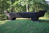 |
3 km to the south of the centre of Jūrkalne, near the old (gravelled) road between Liepāja and Jūrkalne, is the place where the three-year Feliksberga Maritime School existed between 1871 and 1902. The building is long gone, and the memorial has involves an oaken boat with two wooden poles on which old ownership signs have been engraved. |
|
 |
Santa Lasmane owns a farm near Lake Jumurda and manufactured goat’s cheese from 40 dairy goats (60 goats in all). You can buy the cheese there and at local markets. Products are delivered on demand. You can tour the farm, meeting Bonija the goat and her friends, and taste the cheese. |
|
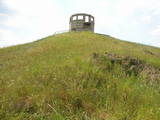 |
This unique territory covers more than 24,400 hectares, and the Soviet military used it as an aviation training centre. The history of the base dates back to 1951, when four kolkhozes were shut down, roads were closed, and several hundred farms and homes were simply moved elsewhere. A civilian presence at the base was restored only in 1993, when several new roads were installed. If you want to get a bird’s eye view of the base and its forests, you have to climb a high, manmade hillock from which commanders watched manoeuvres. We do not recommend that you wander off from the roads!
|
|
 1 day
|
From Kaberneeme the route runs through a forest where you can see piles of stones carried here during the last ice-age. The trail soon climbs about 20 m up to the hiking trail, which runs on the old shore line of Lake Ancylus. The trail continues to the Linnamäe HES and a suspension bridge. Follow the trail over the ancient fortress hill of Linnamäe and continue on the right bank of the River Jägala, until reaching the Jägala waterfall. This is the highest natural waterfall in Estonia, more than 8 m high. The Suka bridge is about 500 metres up from the waterfall. After crossing the river, the trail passes through the Jägala waterfall park. Finally, the trail runs through the village of Koogi and arrives at Jõelähtme. |
|


