
| No | Name | Description |
|---|---|---|
 |
The café is in the historical centre of Tukums in Brīvības Square. Latvian cuisine: Porridge. |
|
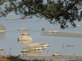 |
This is an area where migrating birds seek shelter and food all around the year. Seen most often here are the red-throated and black-throated loon, the common shelduck, the long-tailed duck, the velvet scoter and the little gull. The territory is also important for the protection of reefs. It lies opposite the Dundaga, Roja and Engure administrative districts, as well as the city of Jūrmala, and it covers 132,173 hectares of territory. The marine parts of the Engure Nature Park and the Ķemeri National Park are covered.
|
|
 |
Located near the train station, the café has a bakery in the basement and a shop and café on the first floor. It offers single and multi-layer torts, various types of cakes (including cream cakes, apple cakes Vecrīga cakes, honey cakes, éclairs and roulettes), pastries (cinnamon, poppy seed, cottage cheese), pierogi (cheese, bacon, etc.), sweet pretzels, plates of meats and savoury snacks. |
|
 |
The craftsman offers useful household products such as terrines, pots to make pickles, dishes of sugar and salt, bowls, etc. You can learn about pottery traditions and watch as the kiln is opened. |
|
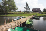 |
This centre offers recreation in a lovely venue on the banks of Lake Zvirgzdi without overnight accommodations. There is a lovely sandy beach for swimmers, as well as boating and fishing. Children can ride a water bike. Active leisure with a country sauna. There is a guesthouse with two rooms for eight people, as well as six camping trailers, 18 sites for tents, and an opportunity to rent a boat. |
|
 |
These are the ruins of World War II fortifications near what is now the Ķegums hydroelectric power plant. One blockhouse was found on the left bank of the Daugava River, approximately one kilometre to the South-Southeast from the plant’s dam. A second is also on the left bank of the river, opposite the Rēzijas campground. It has slid down the abraded shore of the reservoir and is partly underwater. It is mostly accessible by boat.
|
|
 7 days
|
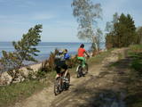
If you enjoy an active lifestyle, this tour is the perfect way to enjoy the culinary heritage hidden in Gauja National Park. The cycling route starts from Strenči and first passes two local breweries at Brenguļi and Valmiermuiža with nice cafés and good beer. On the way to Valmiera you will also stop at Trikāta Village to taste locally made chocolate. From Valmiera, the route goes through a beautiful forest to Cēsis with its charming medieval Old Town. In Cēsis you will visit the local bakery and distillery to taste their production. Also, you will see what a herb and species garden looked like in medieval times. You’ll experience a canoeing trip from Cēsis to Līgatne, one of the nicest parts on the River Gauja with its sandstone banks, remote farmsteads and old-fashioned water-powered ferry. The historic centre of Līgatne Town is linked with the development of its paper mill. Here you can also visit local wine and handicraft producers in one of the artificial caves typical of the area. Cycling the hilly, winding roads of Sigulda, you’ll see Turaida and Sigulda medieval castles, Gūtmaņala Cave and other picturesque views. In Sigulda you will enjoy Latvian traditional meals in the restaurants ”Bucefāls”, ”Aparjods”, and will taste 80 kinds of jam in the Mauriņi guest house. |
|
 |
Guest house Pinska is a family-owned company located on the former Lõpinska country manor land. The food is prepared from local ingredients and according to local traditions. |
|
 |
The largest NATURA 2000 territory in Latvia covers 6% of the country’s area. It is located in parts of the Limbaži, Valmiera and Valka districts, and it is a place of an enormously diverse range of landscapes, biotopes and species. The Salaca River is one of the most important rivers in the entire Baltic Sea region in terms of spawning grounds for salmon. The river valley and its sandstone cliffs attract many visitors. It is no accident that this is the second most popular river in Vidzeme for water tourism. The shore of the Bay of Rīga, which is not very long, also features a great diversity in landscapes and biotopes. At the northern end, we find the Randu meadows. In the central part there are sandy beaches, but at the southern end – 22 kilometres of rocky shoreline. The so-called Northern swamps are found on the border with Estonia, while the Seda heath is one of the most important places in the region for birds to rest and feed during migration. The reserve also features a diverse forest in which one can find all of the types of forest which are common in Latvia. Nature trails and viewing towers or platforms are found in the Randu meadows, on the banks of Lake Burtnieks, along the Planči and Niedrāji-Pilka swamps, on the banks of Lake Dziļezers and Lake Lielezers, and elsewhere. The Skaņākalns park in Mazsalaca is one of the most popular tourist destinations in Northern Vidzeme. The territory boasts many important cultural monuments, including one of the earliest known settlements in Latvia – a fishing settlement and burial ground which date back to the 5th to the 2nd millennium BC.
|
|
 |
This is a comparatively large lake (3 km long and 1.3 km wide). It is shallow (no more than 1.1 m deep) and is classified as a seashore lake. The Vecslocene River flows through it. At the southern end, there is a narrow stream which connects Lake Sloka with Aklo Lake – a shallow and small lake with a dolomite bed at some locations. The best view of Lake Sloka can be seen from the bird watching tower on its north-western shore. This is the only floating bird watching tower in Latvia. Alongside it is the beginning of the 3 km Lake Sloka hiking trail, which passes through the flooded wetlands of the lower reaches of the Vēršupīte. An information stand can be found on the shore of Lake Sloka by the car park. Beyond it is a sulphurous spring. |
|
 2 days
|
On the first day visit a farm specialised in goat breeding and making exclusive cheese, a farm which grows and processes hemp in several generations, berry and fruit grower as well as traditional lamprey fishermen. Next day have a master-class with famous chefs in the restaurant in Riga where these ingredients will be used to prepare first class meals. |
|
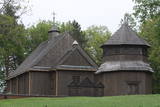 |
Die Kirche hat einen 1800 gebauten einzigartigen achteckigen Glockenturm. Blick auf den Lūšiai-See. |
|
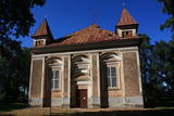 |
The St George Lutheran Church of Subate is on the north-eastern shore of Lesser Lake Subate. The church was built in the Byzantium style in 1685 and 1868 and was commissioned by the owner of the Prode Estate, H.F. Osten-Sacken. This is the only church in Latvia which is reminiscent of the typical appearance of Protestant churches in the late 17th century. The small towers at the corners of the building are of interest. Inside you will find a richly ornamented ensemble of sculptures and wood carvings, including a 17th-century altar, pulpit and pews, as well as artworks from the 17th and 18th century and a bell that was cast in 1682. Some of the interior design was the work of students at the Stelmuže wood carving school. |
|
 |
The restaurant is on the seashore with two terraces and a lovely view of Jūrmala. Latvian cuisine: Marinated herring with cottage cheese, potato pancakes, fried Baltic plaice, lamb, Latvian cheeses. |
|
 |
Small style hotel (6 rooms) - a cafe located in the historical center of Aluksne, 10 minutes walk from the Livonian castle ruins. Many of the hotel’s rooms have wonderful views, including to Alūksne Evangelical Lutheran Church, Cultural Center, art school, lake. Alūksne Castle Island or Marija Island is nearby; from there you can get to Tempļakalns park via a pedestrian bridge. Prepare your own fresh (frozen) berry ice cream, cakes and custom dishes. Seasonally offers different varieties of fruits and berries: strawberries, apples, pears. Orchard 3 km from the town with 1000 fruit trees. |
|
 |
The theme park of wise men of Gotham (Kilpla) is located in Müüsleri village; the park’s attractions arise from legends told in Germany some 400 years ago. Gothamites are funny characters famous for their irrational, impractical and foolish actions. Fun-packed tours and activities are on offer along with craft workshops, themed souvenirs, catering (groups should book in advance), and grounds for pitching tents. |
|
 |
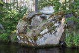
The Boulder of Purmaļi is the biggest boulder in Rēzekne district and one of the 20 biggest boulders in
Latvia. It is located on the escarpment surrounded by the trees and the bushes. Perimeter 18,5 m, height 3,2 m,
lenght 5,6 m, width 4,7, surface volume 30 m3.
|
|
 |
Cēsis is in the centre of the Gauja National Park, but it is not part of the park as such. There are many interesting places in Cēsis to visit and examine. The oldest part of the town is of key interest. The origins of Cēsis can be found at Riekstu hill, which is 18 metres high. Between the 11th and 13th century, there was a wooden castle here built by the Vendians. The hill is in the central part of the castle park, and it offers a good view of the park, pond and the ruins of the Cēsis castle, which can be accessed via a long cascade of stairs. The Cēsis castle (see below) was built in the early 13th century as a residence for masters of the Livonian Order, and it was one of the strongest fortresses in the Baltic territories. Alongside it is the New Cēsis castle, which was built in 1777 where the gate fortifications once stood. The Cēsis Museum of History and Art is in the building, alongside which is a visitors centre and the Cēsis Tourism Information Centre. From the tower of the castle, there is a fine view of the castle ruins, St John's Lutheran church and the northern part of the town. Opposite the New Cēsis castle are stables and a wheelhouse (both from the first half of the 19th century). The Cēsis Exhibition Hall is there today. You can look at the exteriors of the granary, the hut for coachmen, and the old brewery. On the other side of the street is the romantic Maija park, which was installed in the 1830s. The park is popular among parents with children, because there is a playground there. From this area, you can walk down some of the old streets of the town – Lielās Katrīnas, Mazās Katrīnas, Mazā Kalēju, Kalēju and Lielā Līvu streets, plus Līvu Square. The wooden buildings along the streets date back to the late 18th and early 19th century. Torņa Street, which weaves its way along the defensive walls of the Medieval castle, offers a look outside the church of a sculpture by Matiass Jansons, "As the Centuries Pass". Legend says that if you rub the lantern carred by the Old Man of Time, you can see the future. One of the most impressive buildings in Cēsis is St John's Lutheran Church, which was built in the late 13th century for the Livonian Order. It is a basilica built in the Roman style and with Gothic elements. The tower, which is 65 m high, was built in 1853. The building was reconstructed several times during the 20th century. Inside the building are grave epitaphs for masters of the Livonian Order and for bishops. The pulpit was installed in 1748, the oak altar followed in 1858, and the altar painting "The Crucified One" dates back to 1862. The stained glass windows around the altar are of great artistic value. The organ was built in 1907 by the E.F. Walker Company, and the instrument is one of the best concert organs in Latvia. A sun clock featuring the year 1744 is at the south-western corner of the church. It is worth climbing the church's tower. At the foot of the building is Rose Square, which began as a market square in the mid-19th century, remained in place until 1927, and was restored in 2008. This is the central square in the town today. During the Medieval Era, there were stockades here, along with the city's well. Rīgas Street has been the main street of the old town from the very beginning, and it is here that you will find the most architecturally outstanding buildings in town from the 18th and 19th centuries. They include the former Cēsis City Hall, the Fābers building, and the Princess building. At one end of the street is Līvu Square, where, during the 13th century, there was a church, a cemetery and a gate in the town walls. Today the square features a lighted fountain which is on the site of a 13th century well known as Lejas Šķimbēgs. At the other end of the street is a reconstruction of the foundations and surface elements of the Rauna gate that was a part of the town walls in the 14th and 15th centuries. The site offers a good idea about Medieval fortifications and the size and mightiness of gates therein. |
|
 |
This is a cemetery that was originated in the Middle Ages and used until the beginning of the 20th century. A mossy stone fence surrounds the cemetery. Interesting elements in the cemetery include the grave of Heinrihs Jakobsons (1832-1911), who was the first schoolteacher in Mazirbe (the old metal cross is to the left of the main gate), a pine tree of national importance and has a circumference of 3.17 metres (during the Soviet Union someone drilled a hole in the trunk of the tree to access honey), the grave of Niks Freimanis (1845-1908), who is said to have been the prototype for a character in a story and play by Marģers Zariņš, and the Werewolf Grave, which relates to countless ghost stories, including the claim that it is the only known gravesite of a werewolf in Latvia. |
|
 |
Inviting and cosy café in the very heart of Alūksne, with a wide menu for different tastes. Special dishes of the Alūksne area are also served here – salad “Temple Hill”, main course “101 Steps until the Moment of Pleasure” and the dessert “Marienburg Lake Islands”. We offer business lunches and monthly specials, as well as a children's menu. |
|


