
| No | Name | Description |
|---|---|---|
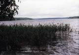 |
Ap 9,5 km garais un līdz kilometru platais ezers atrodas subglaciālā – t.i. ledāja veidotā vagā, tādēļ tas ir ne tikai Lietuvas, bet arī otrs Baltijas dziļākais ezers (pēc dažādiem avotiem 60,5 m vai 62,5 m). Tauragna dienvidu krastā paceļas Taurapils pilskalns (Taurapilio piliakalnis). Saglabājušies nostāsti gan par pagānu priesteri, kas te dzīvojis, gan nogrimušu baznīcu, gan laikiem, kad pilskalnu no visām pusēm apņēmis ūdens. No pilskalna plakuma paveras visaptverošs skats uz Tauragnu. |
|
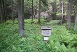 |
Ja apskatīta kodolraķešu bāze, tad var iziet 3,2 km garo Ploštines izziņas taku, kas sākas turpat netālu. Taka ved cauri dažādiem mežu tipiem, iepazīstinot ar sikspārņu būrīšiem (cilvēka radītas sikspārņu dzīves vietas), apkaimes augiem un putniem, kā arī aizsargājamu dabas pieminekli – Pileļu avotu (Pilelio šaltinis). |
|
 |
Stupeļu Hill is 3 km to the South of the Vecumnieki-Ilūkste road. There are no signs, so the castle hill might be difficult to find. The Great Stupeļu Rock, which is discussed further on in this guidebook, is also hard to find when there is vegetation. Stupeļu Hill is approximately 30 m high, and it was one of the highest castle hills in the historical district of Selonia. Archaeologists say that it was first abandoned at the beginning of our era and then populated again during the late Iron Age. It is interesting that iron was extracted and processed near the castle hill. Archaeologists believe that this is the site of one of the earliest “cities” in the region. To the West of the hill is the Great Stupeļu Rock, which is 6.7 m long, 5.6 m wide and up to 2.7 m high. Above ground, it is 35 m3 large, and it may have been a cult location. During archaeological digs in the late 1970s, antiquities from the 10th to the 13th century were found here. |
|
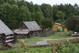 |
Grūti iedomāties, ka vēl joprojām Eiropā ir apdzīvotas vietas, kuru sasniegšanai ir labu laika sprīdi jābrauc pa neapdzīvotu mežu ieskautu smilšainu ceļu, kur tikai paretam var redzēt kādu sēņotāju vai ogotāju! Tāpat kā Zervinos ciemam, arī šim ir piešķirts kultūras mantojuma pieminekļa statuss, jo Linežeris ir viens no dažiem nacionālā parka etnogrāfiskajiem ciemiem. Linežerī ir aplūkojamas 19. – 20. gs. mijā celtās ēkas un apskatāms tā laika ciema plānojums. Šejieniešu tāpat kā citu dzūku galvenā nodarbošanās bija mežistrāde un meža velšu vākšana. Nelielā mērā – arī lauksaimniecība. Apceļojot nacionālā parka etnogrāfiskos ciemus, rodas pamatots jautājums: „Ar ko mūsdienās te nodarbojas cilvēki. Kā viņi spēj dzīvot tik nomaļā vietā”? Jāatzīst, ka lielākā daļa te ierodas tikai vasaras laikā. Neskatoties uz to, etnogrāfiskie ciemi ir ļoti sakopti un joprojām „dzīvi”! |
|
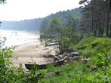 |
There are both sandy beaches with a good infrastructure and a rock beach in Roja. The rocky beach leads to a huge rock that is 2 m high and 12.5 m in diameter. The coastline is lovely with its scattered stones and its unhurried rhythm of time. At the place where the Silupīte River flows into the sea there are remnants of ancient wooden boats and iron nails. In 1939, Roja became the starting point for a closed zone, because the Soviet army and navy were sited there until 1993. The dunes at Krasta Street feature Soviet heritage, including a large cement wall from which border guards used to monitor the sea and catch those who violated the border. Behind the dunes was a base for border guards with everything they needed. Roja housed a Border Guard post and an air defence radio locator. (Source: Roja TIC) |
|


